 Old Cumbria Gazetteer
 |
 |
|
| Rowten Pot Caves, North Yorkshire | ||
| Rowten Pot Caves | ||
| Rowten Caves | ||
| Rowten Pot | ||
| county:- | North Yorkshire | |
| locality type:- | pothole | |
| locality type:- | cave | |
| coordinates:- | SD69747801 (etc) | |
| 1Km square:- | SD6978 | |
| 10Km square:- | SD67 | |
| SummaryText:- | Different parts Grades II and IV; permission from Fore Dales, INgleton. | |
| references:- | Balderston c1890 Brook, D & Davies, G & Long, M H &Sutcliffe, J R: 1975: Northern Caves, vol.4 Whernside and Gragareth: Dalesman Books:: ISBN 0 85206 259 1 |
|
|
|
||
| evidence:- | descriptive text:- Balderston c1890 placename:- Rowantree Holes placename:- Rowton Holes placename:- Rowantree Gulf |
|
| source data:- | Book, Ingleton, Bygone and Present, by Robert R and Margaret
Balderston, published by Simpkin, Marshall and Co, London, and
by Edmndson and Co, 24 High Street, Skipton, Yorkshire, about
1890. goto source goto sourcepage 60:- "..." "Rowantree, or Rowton Holes and Caves." "Above the top of Yordas Scar, to the western side of Kingsdale, four small streams, containing even trout, run" goto sourcepage 61:- "down from Greygareth spur for a short distance, and then precipitate themselves into chasms and caves in the limestone rocks. ... ... Rowantree Holes and Caves; ..." "The grandest of the holes is Rowantree Gulf, which does not appear to have been adequately described, or even explored, by previous cave-hunters. Yes (sic), this is, indeed, a terrific gulf, with beetling rocks ninety feet high to the east - incorrectly measured heretofore, as having a full depth of sixty-nine feet; a huge mass of earth, rocks, ferns, and trees, let down to a great depth on the west; a series of cascades, having an aggregate vertical height of fifty-five feet, just beyond the final reboundings of which the first gulf reaches its greatest depth, as viewed in the chamber, that has only the sky for its canopy. For some distance beyond this point a mass of rocks and earth, foetid with ransoms, half fills the gulf, and completely roofs the fissure beneath, but, on making a descent to the southern end of the internal or rather infernal bridge, one can once more gaze downwards into the depths below, and upwards at the dreadful barriers towering above, with cheeks coldly contiguous in the souther recess, where another awful nook, with the rocks closing in as a roof, but gaping more widely at the basement, discloses a tremendous opening into the mountain, and what appears to be a yawning chasm, reminding one of Gaping Gill Hole, suddenly by a wizard's hand buried in the bowels of the earth. We cast stones from our remote standpoint, and some of these were seven seconds in falling and rebounding, after entering the mouth" goto sourcepage 62:- "down which the water takes an unhesitating leap. A rope, thirty feet long, is required to reach the foot of the cascades previously named. Returning to the top, an examination was made on our way of the cave whence the water issues, but the roof soon became so low that the labour of exploration was unremunerative. On once more scaling the rocks and quitting the gulf, a very small fissure was found some distance to the south, and, concluding from what had been seen below, that this was almost vertically above the ultimate chasm, we judged that by delivering the line under the beetling niche it would go straight down the unmeasured abyss - down went the plummet, down, down, there seemed no stopping, not, at least, until one hundred and seventy-two feet of line dangled down." "'There were three ravens sat on a tree, / Down a down, hey down, hey down. / They were as black as they might be, / With a down. / And one of them said to his mate, / Where shall we our breakfast take! / With a down derry, derry, derry down, down.' / - Old Song, Sixteenth Century." "On a second visit we descended to the bottom of the first chasm by means of ropes, reaching a depth of one hundred feet. In a pool, ninety feet below the verge of the cliff, was a trout, we doubtless being the first to behold this abysmal fish." "Rowting Hole measures at the top, thirty yards in length, eleven in breadth at the northern end, and four at the other, the contour being that of a butcher's cleaver." "The upper mouth of Rowantree Cave is about one hundred and fifty yards from the abyss and lies towards the west. Here the stream enters a breach in a low rock. The first portion is about twenty-seven yards long, and there is a" goto sourcepage 63:- "ledge on each side for some distance, along which one can progress in a peculiar straddling manner without walking in the water. A small lateral entrance then occurs. Once more the cave proceeds thirteen yards further without a break, then another stream joins the first at a third opening to the outer world. After this the subterranean passage is easily accessible for a distance of sixty yards more; but we had to wade ankle deep towards the last, when further progress was debarred by the lowering of the roof. Retracing our steps, it was found that the point of stoppage was not many yards distant from another rent-like opening in the cavern lower down the hill, where the cave was again accessible for a short distance either way; but a few yards further brought us to the point where the waters once more debouch and take their final plunge into the gulf, which words cannot adequately describe." |
|
|
|
||
| evidence:- | old map:- Balderston c1890 map placename:- Rowton Hole and Cave |
|
| source data:- | Map, the hills in the Ingleton area, probably by Robert R
Balderston, engraved by Goodall and Suddick, Leeds, West
Yorkshire, about 1890.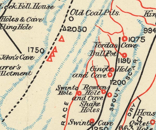 BS1SD67Z.jpg "Rowton Hole and Cave / Shake Holes" item:- private collection : 27.1 Image © see bottom of page |
|
|
|
||
Lakes Guides menu.