 Old Cumbria Gazetteer
 |
 |
|
| Seathwaite Bridge, Dunnerdale-with-Seathwaite | ||
| Seathwaite Bridge | ||
| site name:- | Tarn Beck (2) | |
| locality:- | Seathwaite | |
| civil parish:- | Dunnerdale-with-Seathwaite (formerly Lancashire) | |
| civil parish:- | Ulpha (formerly Cumberland) | |
| county:- | Cumbria | |
| locality type:- | bridge | |
| coordinates:- | SD23199683 | |
| 1Km square:- | SD2396 | |
| 10Km square:- | SD29 | |
| old boundary | ||
| locality:- | Cumberland boundary | |
| locality:- | Lancashire boundary | |
|
|
||
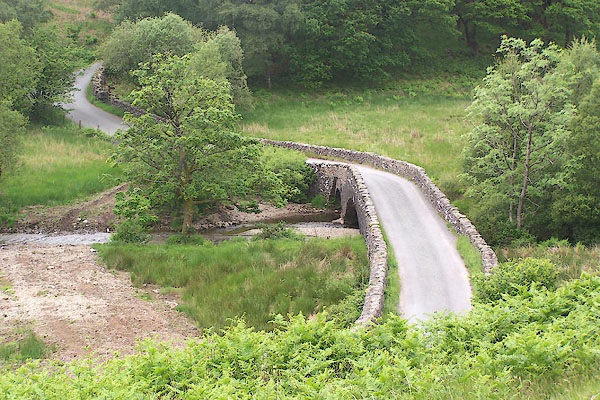 BMG42.jpg (taken 12.6.2006) 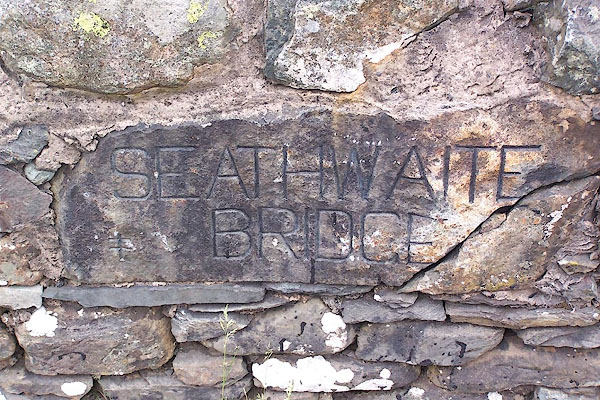 BMG41.jpg Inscribed stone:- "SEATHWAITE BRIDGE" (taken 12.6.2006) |
||
|
|
||
| evidence:- | old map:- OS County Series (Lan 4) placename:- Nettle Slack Bridge |
|
| source data:- | Maps, County Series maps of Great Britain, scales 6 and 25
inches to 1 mile, published by the Ordnance Survey, Southampton,
Hampshire, from about 1863 to 1948. "Nettle Slack Bridge" |
|
|
|
||
| evidence:- | old map:- Donald 1774 (Cmd) |
|
| source data:- | Map, hand coloured engraving, 3x2 sheets, The County of Cumberland, scale about 1
inch to 1 mile, by Thomas Donald, engraved and published by Joseph Hodskinson, 29
Arundel Street, Strand, London, 1774.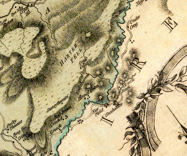 D4SD29NW.jpg double line across a river; a bridge nr Nettleslack item:- Carlisle Library : Map 2 Image © Carlisle Library |
|
|
|
||
| evidence:- | database:- Listed Buildings 2010 placename:- Seathwaite Bridge |
|
| source data:- | courtesy of English Heritage "SEATHWAITE BRIDGE / / / DUNNERDALE WITH SEATHWAITE / SOUTH LAKELAND / CUMBRIA / II / 75852 / SD2319896835" |
|
| source data:- | courtesy of English Heritage "Bridge over Tarn Beck. Probably C18, widened. Stone rubble. 2 segmental arches, smaller to west. Later parapets. Stone inscribed. "SEATHWAITE/BRIDGE"." |
|
|
|
||
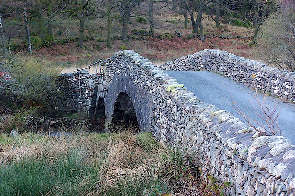 BLK42.jpg (taken 17.11.2005) |
||
|
|
||
 Lakes Guides menu.