 Old Cumbria Gazetteer
 |
 |
|
| Spout House, Crosthwaite | ||
| out of sight | ||
| Spout House | ||
| Spout Farm | ||
| locality:- | Crosthwaite | |
| civil parish:- | Crosthwaite and Lyth (formerly Westmorland) | |
| county:- | Cumbria | |
| locality type:- | buildings | |
| coordinates:- | SD44429175 | |
| 1Km square:- | SD4491 | |
| 10Km square:- | SD49 | |
|
|
||
| evidence:- | old map:- Jefferys 1770 (Wmd) placename:- Spout |
|
| source data:- | Map, 4 sheets, The County of Westmoreland, scale 1 inch to 1
mile, surveyed 1768, and engraved and published by Thomas
Jefferys, London, 1770.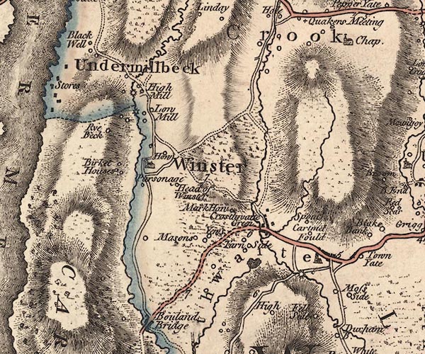 J5SD49SW.jpg "Spout" circle, labelled in italic lowercase text; settlement, farm, house, or hamlet? item:- National Library of Scotland : EME.s.47 Image © National Library of Scotland |
|
|
|
||
| evidence:- | database:- Listed Buildings 2010 placename:- Spout House |
|
| source data:- | courtesy of English Heritage "SPOUT HOUSE / / / CROSTHWAITE AND LYTH / SOUTH LAKELAND / CUMBRIA / II / 77102 / SD4442691752" |
|
|
|
||
| hearsay:- |
There is an ornamented round stone on the front gable, which an owner called a pigeon stone - it was a favourite perch for pigeons! But is also suggested that it is a survival of an old custom of having your defeated enemy's head on a stake at your door. |
|
| Palmer 1945 |
||
|
|
||
 Lakes Guides menu.