 Old Cumbria Gazetteer
 |
 |
|
| St Herbert's Island, Derwent Water | ||
| St Herbert's Island | ||
| site name:- | Derwent Water | |
| civil parish:- | Above Derwent (formerly Cumberland) | |
| county:- | Cumbria | |
| locality type:- | island | |
| coordinates:- | NY25932125 (about) | |
| 1Km square:- | NY2521 | |
| 10Km square:- | NY22 | |
|
|
||
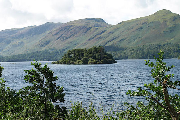 BPQ04.jpg Maiden Moor behind. (taken 24.8.2008) 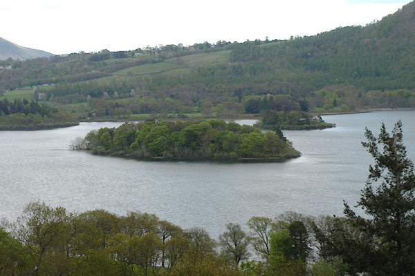 BYI33.jpg (taken 17.5.2013) |
||
|
|
||
| evidence:- | old map:- OS County Series (Cmd 64 10) placename:- St Herbert's Island |
|
| source data:- | Maps, County Series maps of Great Britain, scales 6 and 25
inches to 1 mile, published by the Ordnance Survey, Southampton,
Hampshire, from about 1863 to 1948. |
|
|
|
||
| evidence:- | descriptive text:- Simpson 1746 |
|
| source data:- | Atlas, three volumes of maps and descriptive text published as
'The Agreeable Historian, or the Compleat English Traveller
...', by Samuel Simpson, 1746. goto source goto source"..." "... in which [Derwent Water] there are three Islands, ... another is suppos'd by Bede to be the Place where St. Herbert lead an Hermit's Life; ..." |
|
|
|
||
| evidence:- | old map:- Gents Mag 1751 |
|
| source data:- | Map, uncoloured engraving, Map of the Black Lead Mines in
Cumberland, and area, scale about 2 miles to 1 inch, by George
Smith, published in the Gentleman's Magazine, 1751.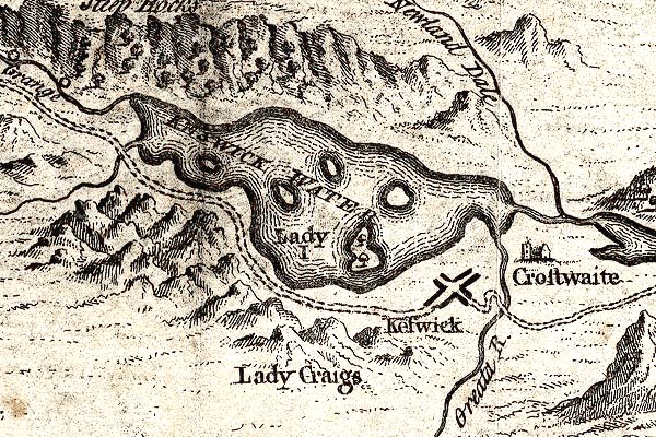 GM1311.jpg island item:- JandMN : 114 Image © see bottom of page |
|
|
|
||
| evidence:- | perhaps old map:- Bowen and Kitchin 1760 |
|
| source data:- | Map, hand coloured engraving, A New Map of the Counties of
Cumberland and Westmoreland Divided into their Respective Wards,
scale about 4 miles to 1 inch, by Emanuel Bowen and Thomas
Kitchin et al, published by T Bowles, Robert Sayer, and John
Bowles, London, 1760. BO18NY21.jpg in Derwent Water item:- Armitt Library : 2008.14.10 Image © see bottom of page |
|
|
|
||
| evidence:- | old map:- Donald 1774 (Cmd) |
|
| source data:- | Map, hand coloured engraving, 3x2 sheets, The County of Cumberland, scale about 1
inch to 1 mile, by Thomas Donald, engraved and published by Joseph Hodskinson, 29
Arundel Street, Strand, London, 1774.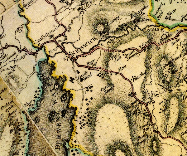 D4NY22SE.jpg island in Derwent Water item:- Carlisle Library : Map 2 Image © Carlisle Library |
|
|
|
||
| evidence:- | descriptive text:- West 1778 (11th edn 1821) |
|
| source data:- | Guide book, A Guide to the Lakes, by Thomas West, published by
William Pennington, Kendal, Cumbria once Westmorland, and in
London, 1778 to 1821. goto source Page 90:- "[Derwent Water] ... St. Herbert's-island, which traverses the lake in an oblique direction, and has a fine effect. ..." "..." goto sourcePage 115:- "[Mr Pennant's description] '... The isles that decorate this water are finely disposed, and very distinct, rise with gentle and regular curvatures above the surface, consist of verdant turf, or are planted with various trees. ..." "'St. Herbert's-isle was noted for the residence of that saint, the bosom friend of St. Cuthbert, who wished, and obtained his desire of departing this life on the same day, hour, and minute, with that holy man [1]. ...'" "[1] In the register of Bishop Appleby, in the year 1374, there is an indulgence of forty days to every of the inhabitants of the parish of Crosthwaite, that should attend the vicar of St. Herbert's-island on the 13th of April, yearly, and there to celebrate mass in memory of St. Herbert." "Nicholson's Cumberland, page 86." |
|
|
|
||
| evidence:- | old map:- Crosthwaite 1783-94 (Der) placename:- St Herbert's Island |
|
| source data:- | Map, uncoloured engraving, An Accurate Map of the Matchless Lake
of Derwent, ie Derwent Water, scale about 3 inches to 1 mile, by
Peter Crosthwaite, Keswick, Cumberland, 1783, version published
1800. CT2NY21P.jpg "St. Herbert's I." In the map title:- "St. Herbert's Island, Sir Wilfrid Lawsons. Bart." item:- Armitt Library : 1959.191.3 Image © see bottom of page |
|
|
|
||
| evidence:- | probably old map:- West 1784 map |
|
| source data:- | Map, hand coloured engraving, A Map of the Lakes in Cumberland,
Westmorland and Lancashire, scale about 3.5 miles to 1 inch,
engraved by Paas, 53 Holborn, London, about 1784.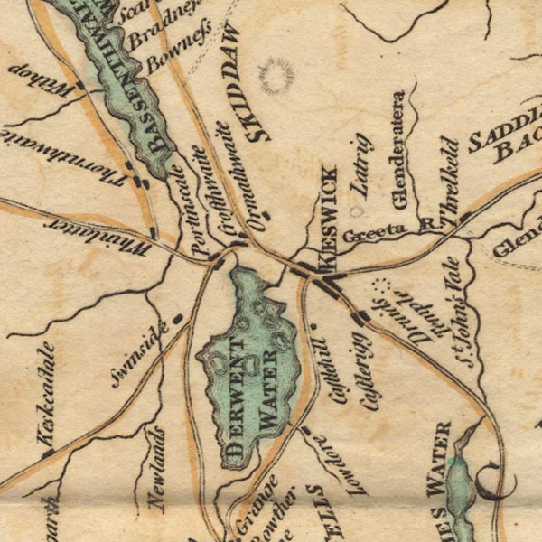 Ws02NY22.jpg item:- Armitt Library : A1221.1 Image © see bottom of page |
|
|
|
||
| evidence:- | old sketch map:- Gilpin 1786 placename:- St Herbert's Island |
|
| source data:- | Sketch map, Keswick Lake ie Derwent Water, Cumberland, by William Gilpin, 1772-74. goto source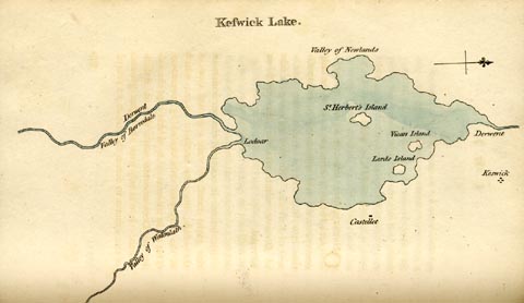 click to enlarge click to enlargeGLP312.jpg Plate vol 1 opposite p.179 in Observations on Picturesque Beauty published by T Cadell and W Davies, Strand, London, 1808. caption from the list of plates:- "This plan of Keswick-lake means only to express the general shape of it; and the relative situation of it's several parts." item:- Armitt Library : A918.12 Image © see bottom of page |
|
|
|
||
| evidence:- | old text:- Gilpin 1786 placename:- St Herbert's Island |
|
| source data:- | Book, Observations, Relative Chiefly to Picturesque Beauty, Made
in the Year 1772, on Several Parts of England, Particularly the
Mountains, and Lakes of Cumberland Westmoreland, by Rev William
Gilpin, 1772-74; published 1786-1808. goto source vol.1 p.180 "The lake of Derwent, or Keswick-lake, as it is generally called, is contained within a circumference of about ten miles; presenting itself in a circular form, tho in fact it is rather oblong. It's area is interspersed with four or five islands; three of which only are of consequence, Lord's island, Vicar's island, and St. Herbert's island: but none of them is comparable to the island on Windermere, in point either of size, or beauty." "If a painter were desirous of studying the circumference of the lake from one station, St. Herbert's island is the spot he should choose; from whence, as from a centre, he might see it in rotation. I have seen a set of drawings taken from this stand; which were hung round a circular room, and intended to give a general idea of the boundaries of the lake. But as no representation could be given of the lake itself; the idea was lost, and the drawings made but an awkward appearance." goto sourcevol.1 p.184 "..." "To the formality of it's shores may be added the formality of it's islands. They are round, regular, and similar spots, as they appear from most points of view; formal in their situation, as well as in their shape; and of little advantage to the scene. ..." |
|
|
|
||
| evidence:- | old text:- Clarke 1787 placename:- St Herbert's Island |
|
| source data:- | Guide book, A Survey of the Lakes of Cumberland, Westmorland,
and Lancashire, written and published by James Clarke, Penrith,
Cumberland, and in London etc, 1787; published 1787-93. goto source Page 84:- "... St Herbert's; so called from that Romish Saint who had an hermitage there: This island, (upon which some remains of his cell are yet to be seen) was given to him by St Cuthbert, (see Burn and Nicholson,) but is now the property of Sir Gilfred Lawson, Baronet." |
|
|
|
||
| evidence:- | old map:- Clarke 1787 map (Der) placename:- St Herbert's Island |
|
| source data:- | Map, uncoloured engraving, Map of Derwentwater and its Environs,
scale about 13 ins to 1 mile, by James Clarke, engraved by S J
Neele, published by James Clarke, Penrith, Cumberland and in
London etc, 1787.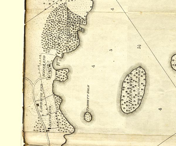 CL152521.jpg "ST HERBERT'S / SIR GILD. LAWSON BART." wooded island item:- private collection : 169 Image © see bottom of page |
|
|
|
||
| evidence:- | old text:- Camden 1789 (Gough Additions) placename:- St Herbert's Isle placename:- St Hereberts Isle |
|
| source data:- | Book, Britannia, or A Chorographical Description of the Flourishing Kingdoms of England,
Scotland, and Ireland, by William Camden, 1586, translated from the 1607 Latin edition
by Richard Gough, published London, 1789. goto source Page 182:- "..." "The friendship between St. Cuthbert and St. Herbert, who died on the same day and minute at Carlisle and Lindisfarne, are largely recited by Bede, all which is repeated in an instrument whereby Thomas de Apulby, bishop of Carlisle 1374, requires the vicar of Crosthwait to say a yearly mass in St. Herbert's isle April 13th, in commemoration of that saint, and grants 40 days indulgence to such of his parishioners as shall devouly attend the service." ""... St. Hereberts isle, where is a chapel, ..."" |
|
|
|
||
| evidence:- | old print:- Green 1810 (plate 31) |
|
| source data:- | Print, soft ground etching, Islands on Derwent Water from Castlerigg, Keswick, Cumberland,
by William Green, Ambleside, Westmorland, 1810.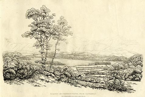 click to enlarge click to enlargeGN1231.jpg From near right to far - Derwent Isle, Lord's Island, St Herbert's Island? Plate 31 in Sixty Studies from Nature, 1810. printed at top right:- "31" printed at bottom:- "ISLANDS ON DERWENT WATER FROM CASTLERIGG. / Drawn and Engraved by William Green, and Published at Ambleside, June 24, 1810." watermark:- "J WHATMAN / 1813" item:- Armitt Library : A6641.31 Image © see bottom of page |
|
|
|
||
| evidence:- | old text:- Wordsworth 1810 item:- oak trees |
|
| source data:- | Guide book, A Description of the Scenery of the Lakes, later A
Guide through the District of The Lakes, by William Wordsworth,
1810-35. goto source page 62 "The venerable wood that had grown for centuries round the small house called St. Herbert's Hermitage, had indeed some years before been felled by its native proprietor, and the whole island planted anew with Scotch firs, left to spindle up by each other's side - a melancholy phalanx, defying the power of the winds, and disregarding the regret of the spectator, who might otherwise have cheated himself into a belief, that some of the decayed remains of those oaks, the place of which was in this manner usurped, had been planted by the Hermit's own hand. ..." |
|
|
|
||
| evidence:- | old text:- Farington 1816 placename:- St Herbert's Island |
|
| source data:- | Descriptive text:- "... Much of the beauty of this Lake [Derwent Water] is derived from the islands, four
or five in number, which are interspersed in it: the principal of these are, Lord's
Island and that of St. Herbert. ... St. Herbert's Island lies nearly in the middle
of the Lake, and is indebted for its appellation to a Saint of the same name, who
lived in the seventh century, and erected a hermitage here: it comprises about four
acres of land, which are planted with firs and other trees." item:- Armitt Library : A6666.15 Image © see bottom of page |
|
|
|
||
| evidence:- | outline view:- Otley 1823 (8th edn 1849) placename:- St Herbert's Isle |
|
| source data:- | Engraving, outline view of mountains, Derwent Water from Crow Park, drawn by T Binns,
engraved by O Jewitt, opposite p.10 of A Descriptive Guide of the English Lakes, by
Jonathan Otley, 8th edition, 1849.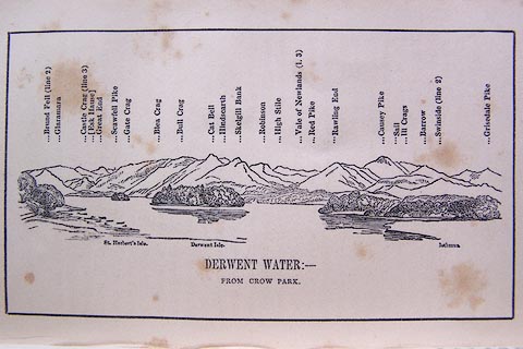 click to enlarge click to enlargeO80E06.jpg item:- Armitt Library : A1180.7 Image © see bottom of page |
|
|
|
||
| evidence:- | descriptive text:- Otley 1823 (5th edn 1834) placename:- St Herbert's Isle item:- hermit's cell; fishing |
|
| source data:- | Guide book, A Concise Description of the English Lakes, the
mountains in their vicinity, and the roads by which they may be
visited, with remarks on the mineralogy and geology of the
district, by Jonathan Otley, published by the author, Keswick,
Cumberland now Cumbria, by J Richardson, London, and by Arthur
Foster, Kirkby Lonsdale, Cumbria, 1823; published 1823-49,
latterly as the Descriptive Guide to the English Lakes. goto source Page 18:- "..." "One [island], nearer the middle of the lake, is called St. Herbert's Isle, from being the residence of that holy man; who, according to the Venerable Bede, was contemporary with St. Cuthbert, and died about A.D. 687. It appears that several centuries afterwards, the anniversary of his death was, by the Bishop of the diocese, enjoined to be celebrated upon this spot in religious offices. Some remains of what is said to have been his cell are still to be seen among the trees with which the island is covered. Near thirty years ago, a small grotto or fishing cot was built by the late Sir Wilfred Lawson, of Brayton House, to whose successor the island now belongs." |
|
|
|
||
| evidence:- | descriptive text:- Ford 1839 (3rd edn 1843) placename:- St Herbert's Island |
|
| source data:- | Guide book, A Description of Scenery in the Lake District, by
Rev William Ford, published by Charles Thurnam, Carlisle, by W
Edwards, 12 Ave Maria Lane, Charles Tilt, Fleet Street, William
Smith, 113 Fleet Street, London, by Currie and Bowman,
Newcastle, by Bancks and Co, Manchester, by Oliver and Boyd,
Edinburgh, and by Sinclair, Dumfries, 1839. goto source Page 54:- "... St. Herbert's Island, nearly in the middle of the lake, was the residence of the saint whose name it bears. In his life-time, he was an intimate with St. Cuthbert of Durham, and died, according to Bede, in 687. There is a small grotto near the remains of what are thought to be the hermit's cell. The island belongs to Sir Wilfrid Lawson, of Brayton Hall, Bart. ..." |
|
|
|
||
| evidence:- | old map:- Garnett 1850s-60s H placename:- St Herberts Island |
|
| source data:- | Map of the English Lakes, in Cumberland, Westmorland and
Lancashire, scale about 3.5 miles to 1 inch, published by John
Garnett, Windermere, Westmorland, 1850s-60s.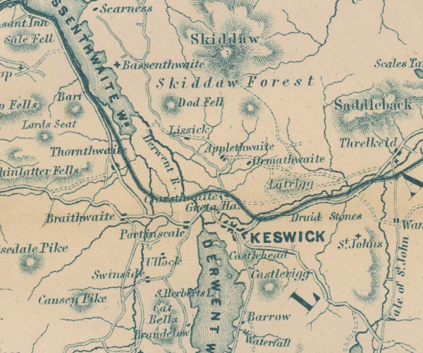 GAR2NY22.jpg "St. Herberts I." island item:- JandMN : 82.1 Image © see bottom of page |
|
|
|
||
| evidence:- | old text:- Martineau 1855 placename:- St Herbert's Isle |
|
| source data:- | Guide book, A Complete Guide to the English Lakes, by Harriet
Martineau, published by John Garnett, Windermere, Westmorland,
and by Whittaker and Co, London, 1855; published 1855-76. goto source Page 74:- "... the hermit, the dear friend of St. Cuthbert, who lived in St. Herbert's Isle in the seventh century, is somehow mixed up in legends, in local imaginations which are careless of dates, with the same family [Derwentwater Family]. All that is known of St. Herbert is, that he really had a hermitage in that island, and that St. Cuthbert and he used to meet, either at Lindisfarn or Derwentwater, once a-year. The legend about their deaths is well known; that, according to their prayer, they died on the same day. There is beauty in the tradition that the man of action and the man of meditation, the propagandist and the recluse, were so dear to each other, and so congenial. ..." |
|
|
|
||
| evidence:- | descriptive text:- Bede c731 |
|
| source data:- | ||
| source data:- | Courtesy of Penguin Books (licence PM6935) "There was a priest of praiseworthy life named Heribert, who had for a long time enjoyed a spiritual friendship with the man of God [St Cuthbert]. He lived the life of a hermit on an island in a great lake which is the source of the river Derwent, and used to visit Cuthbert each year to seek his advice on matters of eternal salvation. Hearing that Cuthbert was at the city of Lugubalia [Carlisle], he went to visit him as usual, wishing to be ever more fervently inspired to heavenly desires by his salutary guidance. As each in turn discoursed on the joys of the heavenly life, Cuthbert said among other things: 'Brother Heribert, remember that whatever you wish to ask or tell me, you must do before we part, because we shall not see one another again in this world. For I know that the day of my death is approaching, and I shall soon leave this earthly dwelling.' At these words, the other fell at his feet with sighs and tears, saying: 'In the name of our Lord, I beg you not to leave me! Remember that I am your most devoted friend, and ask God of His mercy to grant that as we have served Him together on earth, we may pass away to the heavenly vision together. ...'" "... when they parted, they never saw one another again in this life, and before long, on the twentieth of March, their souls left their bodies on the same day, and were born by angels to see the beatific vision in the kingdom of heaven. ..." |
|
|
|
||
| evidence:- | old print:- |
|
| source data:- | Print, coloured lithograph? St Herbert's Island, Derwentwater, published late 19th
century?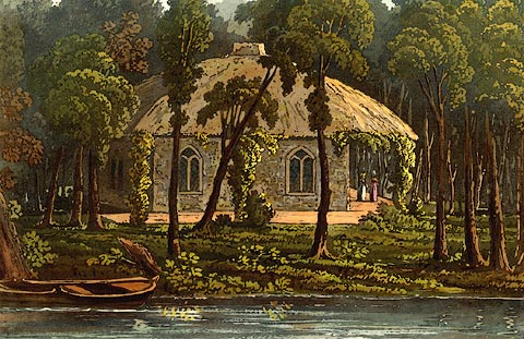 click to enlarge click to enlargePR0410.jpg Otley, 1823, notes that 'Near thirty years ago, a small grotto or fishing cot was built by the late Sir Wilfred Lawson, of Brayton House, to whose successor the island now belongs.' item:- Dove Cottage : 2008.107.403 Image © see bottom of page |
|
|
|
||
| evidence:- | outline view:- Black 1856 (23rd edn 1900) placename:- St Herbert's Isle |
|
| source data:- | Print, lithograph, Outline Views, Skiddaw and Derwent Water - Mountains as seen at
Lodore Hotel, and Mountains as seen at the Third Gate on Ascending Latrigg on the
Way to Skiddaw, by J Flintoft, Keswick, Cumberland, engraved by R Mason, Edinburgh,
Lothian, about 1900.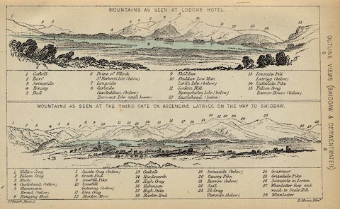 click to enlarge click to enlargeBC08E4.jpg "... St. Herbert's Isle ..." item:- JandMN : 37.14 Image © see bottom of page |
|
|
|
||
| evidence:- | outline view:- Black 1841 (3rd edn 1846) placename:- St Herbert's Isle |
|
| source data:- | Print, engraving, outline view, Mountains as seen at Lowdore Inn, and Mountains as
seen at the Third Gate on Ascending Latrigg on the Way to Skiddaw, by J Flintoft,
Keswick, Cumberland, engraved by R Mason, Edinburgh, Lothian, about 1846.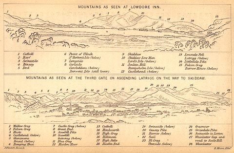 click to enlarge click to enlargeBC02E4.jpg "... St. Herbert's Isle ..." item:- JandMN : 32.7 Image © see bottom of page |
|
|
|
||
| evidence:- | outline view:- Tattersall 1836 (version 1869) placename:- St Herbert's Isle |
|
| source data:- | Print, hand coloured, Derwentwater and Bassenthwaite Lakes, from the road to Watendlath,
Cumberland, drawn by George Tattersall, 1836, engraved by W F Topham, published by
T J Allman, 463 Oxford Street, London, 1869.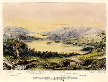 click to enlarge click to enlargeTAT212.jpg Included in The Lakes of England, by W F Topham. printed at bottom:- "DERWENTWATER and BASSENTHWAITE LAKES, / from the road to Watendlath." printed at bottom:- "Swinside. / Lord's Seat. / Barff. / St. Herbert's I. / Bassenthwaite L. / Ramps I. / Vicar's I. / Lord's I. / Skiddaw Dodd. / Castle Hill. / Keswick. / Skiddaw. / Latrigg. / Falcon Crag." item:- Armitt Library : A1067.12 Image © see bottom of page |
|
|
|
||
| evidence:- | outline view:- Tattersall 1836 placename:- St Herbert's Isle |
|
| source data:- | Print, engraving, Derwentwater and Bassenthwaite Lakes, from the road to Watenflath,
Cumberland, drawn by George Tattersall, engraved by W F Topham, published by Sherwood
and Co, Paternoster Row, London, about 1836. click to enlarge click to enlargeTAT130.jpg The print is captioned with mountain names and acts as an outline view. Tipped in opposite p.77 of The Lakes of England, by George Tattersall. printed at bottom:- "DERWENTWATER and BASSENTHWAITE LAKES, / from the road to Watendlath." printed at bottom left to right:- "Swinside. / Lord's Seat. / Barff. / St. Herbert's I. / Bassenthwaite L. / Ramp's I. / Vicar's I. / Lord's I. / Skiddaw Dodd. / Castle Hill. / Keswick. / Skiddaw. / Latrigg. / Falcon Crag." item:- Armitt Library : A1204.31 Image © see bottom of page |
|
|
|
||
| evidence:- | outline view:- placename:- St Herbert's Island |
|
| source data:- | Print, uncoloured engraving, Derwentwater and Bassenthwaite Lakes from the Road to
Watendlath, Cumberland, published by Sherwood and Co, London, 1836?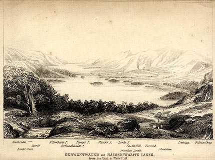 click to enlarge click to enlargePR0370.jpg The view is from just above Ashness Bridge. Objects in the view are identified by a caption at the bottom (unfortunately the print is pale, so some objects are unclear, and the caption seems to be a little misaligned) - Swinside, Lord's Seat, Barff, St. Herbert's I., Bassenthwaite L., Ramp's I., Vicar's I., Lord's I., Skiddaw Dodd, Castle Hill, Keswick, Skiddaw, Latrigg, Falcon Crag. printed at bottom:- "DERWENTWATER and BASSENTHWAITE LAKES. / from the Road to Watendlath." item:- Dove Cottage : 2008.107.370 Image © see bottom of page |
|
|
|
||
| evidence:- | old print:- Fielding 1822 (plate 21) |
|
| source data:- | Print, uncoloured engraving, St Herbert's Island, Derwent Water, Cumberland, by Theodore
H A Fielding, published by Thomas McLean, 26 Haymarket, London, et al, 1822.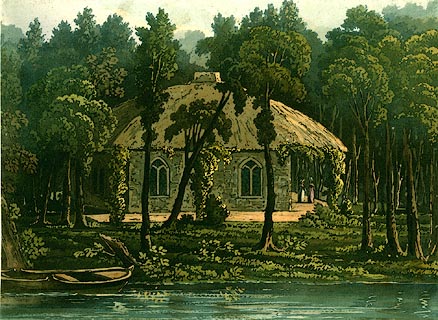 click to enlarge click to enlargePR0124.jpg Plate 21 in the set of prints, Cumberland, Westmoreland, and Lancashire Illustrated. item:- Dove Cottage : 2008.107.124 Image © see bottom of page |
|
|
|
||
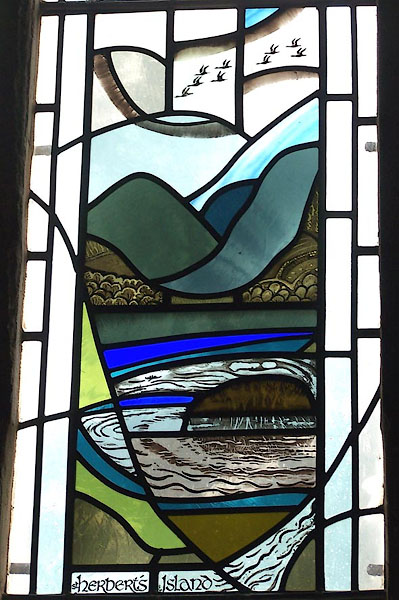 BMR15.jpg Stained glass in St John's Church, St Herbert's Island, memorial to Canon Richard Watson, d.1990. (taken 17.9.2006) |
||
|
|
||
Lakes Guides menu.