Old Cumbria Gazetteer
 |
 |
|
||
| St John's Beck | ||||
| runs into:- |  Greta, River Greta, River |
|||
|
|
||||
| civil parish:- | St John's Castlerigg and Wythburn (formerly Cumberland) | |||
| county:- | Cumbria | |||
| locality type:- | river | |||
| 1Km square:- | NY3123 (etc) | |||
| 10Km square:- | NY32 | |||
|
|
||||
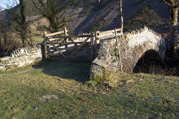
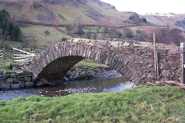
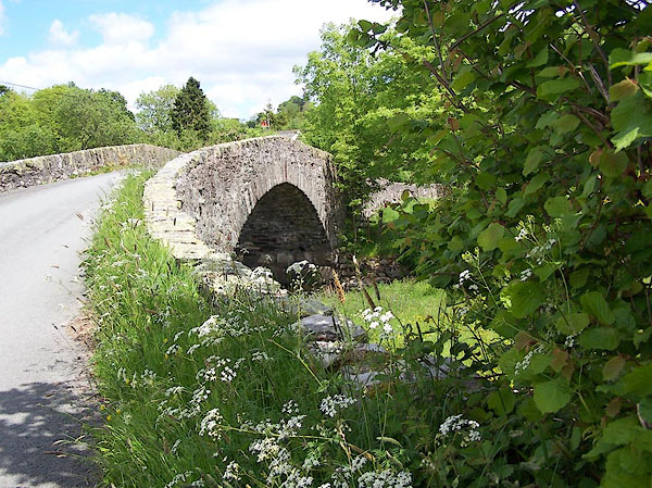
 BND93.jpg At Sosgill Bridge. (taken 5.2.2007)  BXT39.jpg (taken 13.12.2012) |
||||
|
|
||||
| evidence:- | old map:- OS County Series (Cmd 64 12) placename:- St John's Beck |
|||
| source data:- | Maps, County Series maps of Great Britain, scales 6 and 25
inches to 1 mile, published by the Ordnance Survey, Southampton,
Hampshire, from about 1863 to 1948. |
|||
|
|
||||
| evidence:- | old map:- Saxton 1579 |
|||
| source data:- | Map, hand coloured engraving, Westmorlandiae et Cumberlandiae Comitatus ie Westmorland
and Cumberland, scale about 5 miles to 1 inch, by Christopher Saxton, London, engraved
by Augustinus Ryther, 1576, published 1579-1645.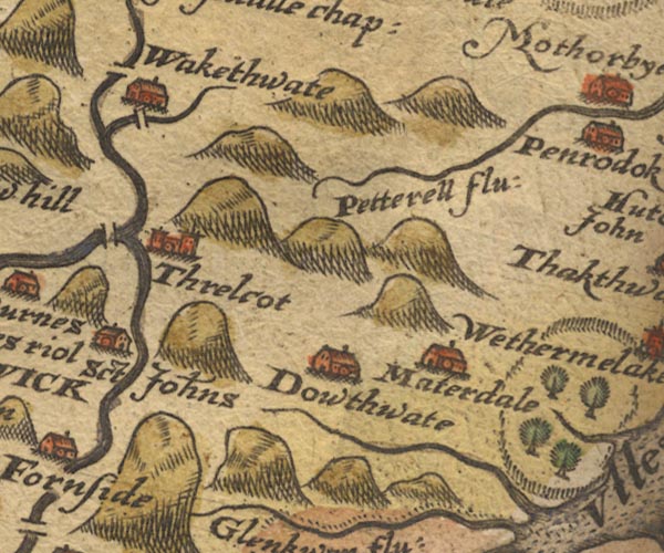 Sax9NY32.jpg item:- private collection : 2 Image © see bottom of page |
|||
|
|
||||
| evidence:- | old map:- Mercator 1595 (edn?) |
|||
| source data:- | Map, hand coloured engraving, Northumbria, Cumberlandia, et
Dunelmensis Episcopatus, ie Northumberland, Cumberland and
Durham etc, scale about 6.5 miles to 1 inch, by Gerard Mercator,
Duisberg, Germany, about 1595.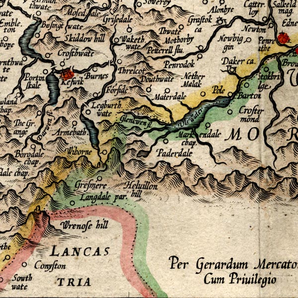 MER8CumF.jpg "" double line with stream lines; river, running into the Greta item:- JandMN : 169 Image © see bottom of page |
|||
|
|
||||
| evidence:- | old map:- Speed 1611 (Cmd) |
|||
| source data:- | Map, hand coloured engraving, Cumberland and the Ancient Citie
Carlile Described, scale about 4 miles to 1 inch, by John Speed,
1610, published by J Sudbury and George Humble, Popes Head
Alley, London, 1611-12.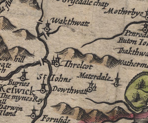 SP11NY32.jpg double line, runs into the Great item:- private collection : 16 Image © see bottom of page |
|||
|
|
||||
| evidence:- | old map:- Jansson 1646 |
|||
| source data:- | Map, hand coloured engraving, Cumbria and Westmoria, ie
Cumberland and Westmorland, scale about 3.5 miles to 1 inch, by
John Jansson, Amsterdam, Netherlands, 1646.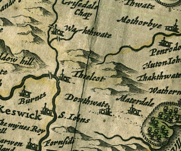 JAN3NY32.jpg Double wiggly line, tapering to single. item:- JandMN : 88 Image © see bottom of page |
|||
|
|
||||
| evidence:- | old map:- Ogilby 1675 (plate 96) placename:- Thurlemire Fluvius |
|||
| source data:- | Road strip map, hand coloured engraving, the Road from Kendal to
Cockermouth, and the Road from Egremond to Carlisle, scale about
1 inch to 1 mile, by John Ogilby, London, 1675.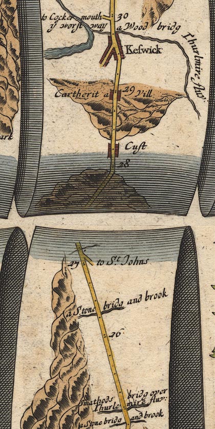 OG96m025.jpg In mile 25, Cumberland. "Smathods bridg over Thurlemire fluv:" river crossed by the road, no bridge drawn. item:- JandMN : 22 Image © see bottom of page |
|||
|
|
||||
| evidence:- | old map:- Sanson 1679 |
|||
| source data:- | Map, hand coloured engraving, Ancien Royaume de Northumberland
aujourdhuy Provinces de Nort, ie the Ancient Kingdom of
Northumberland or the Northern Provinces, scale about 9.5 miles
to 1 inch, by Nicholas Sanson, Paris, France, 1679. click to enlarge click to enlargeSAN2Cm.jpg item:- Dove Cottage : 2007.38.15 Image © see bottom of page |
|||
|
|
||||
| evidence:- | old map:- Morden 1695 (Cmd) |
|||
| source data:- | Map, uncoloured engraving, Cumberland, scale about 4 miles to 1
inch, by Robert Morden, 1695, published by Abel Swale, the
Unicorn, St Paul's Churchyard, Awnsham, and John Churchill, the
Black Swan, Paternoster Row, London, 1695-1715. MD12NY32.jpg item:- JandMN : 90 Image © see bottom of page |
|||
|
|
||||
| evidence:- | perhaps old map:- Bowen 1720 (plate 260) placename:- Thurlmire Fluvius |
|||
| source data:- | Road strip map, uncoloured engraving, pl.260, The Road from
Kendal to Cockermouth, scale about 2 miles to 1 inch, with
sections in Westmorland and Cumberland, published by Emanuel
Bowen, St Katherines, London, 1720.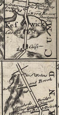 B260m25.jpg "Smathode Bridge over Thurlmire Fluvius" At mile 25. item:- private collection : 1.260 Image © see bottom of page |
|||
|
|
||||
| evidence:- | old map:- Simpson 1746 map (Wmd) |
|||
| source data:- | Map, uncoloured engraving, Westmorland, scale about 8 miles to 1
inch, printed by R Walker, Fleet Lane, London, 1746. SMP2NYG.jpg Wiggly line, flowing north into the Derwent. item:- Dove Cottage : 2007.38.59 Image © see bottom of page |
|||
|
|
||||
| evidence:- | old map:- Bowen and Kitchin 1760 |
|||
| source data:- | Map, hand coloured engraving, A New Map of the Counties of
Cumberland and Westmoreland Divided into their Respective Wards,
scale about 4 miles to 1 inch, by Emanuel Bowen and Thomas
Kitchin et al, published by T Bowles, Robert Sayer, and John
Bowles, London, 1760.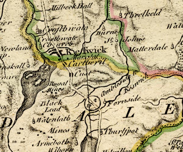 BO18NY21.jpg wiggly line, into the Greta item:- Armitt Library : 2008.14.10 Image © see bottom of page |
|||
|
|
||||
| evidence:- | old map:- Donald 1774 (Cmd) |
|||
| source data:- | Map, hand coloured engraving, 3x2 sheets, The County of Cumberland, scale about 1
inch to 1 mile, by Thomas Donald, engraved and published by Joseph Hodskinson, 29
Arundel Street, Strand, London, 1774.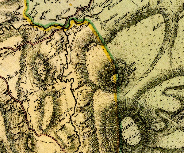 D4NY32SW.jpg 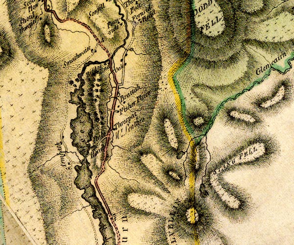 D4NY31NW.jpg single or double wiggly line; a river into the Greta item:- Carlisle Library : Map 2 Images © Carlisle Library |
|||
|
|
||||
| evidence:- | old map:- West 1784 map |
|||
| source data:- | Map, hand coloured engraving, A Map of the Lakes in Cumberland,
Westmorland and Lancashire, scale about 3.5 miles to 1 inch,
engraved by Paas, 53 Holborn, London, about 1784.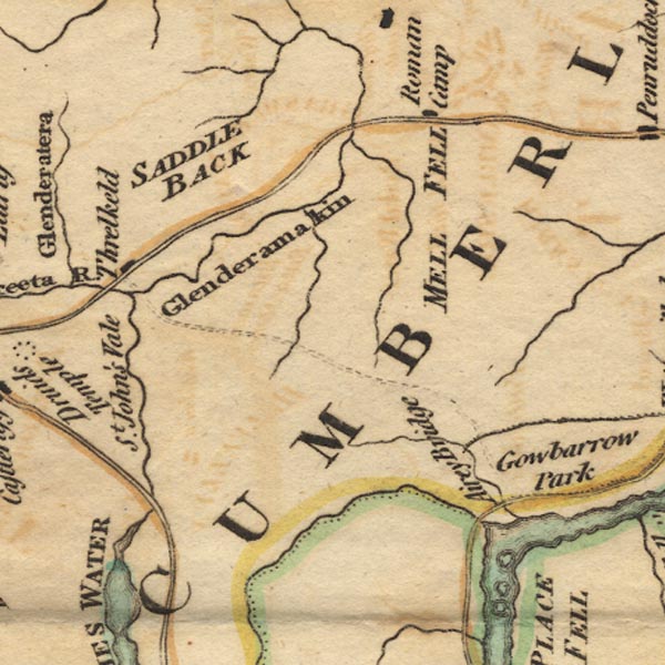 Ws02NY32.jpg item:- Armitt Library : A1221.1 Image © see bottom of page |
|||
|
|
||||
| evidence:- | old text:- Clarke 1787 placename:- Wanthwaite Beck |
|||
| source data:- | Guide book, A Survey of the Lakes of Cumberland, Westmorland,
and Lancashire, written and published by James Clarke, Penrith,
Cumberland, and in London etc, 1787; published 1787-93. goto source Page 62:- "... the river Greeta, which contains the waters of ... Wanthwaite-Beck, ..." |
|||
|
|
||||
| evidence:- | old map:- Clarke 1787 map (Ambleside to Keswick) |
|||
| source data:- | Map, A Map of the Roads Lakes etc between Keswick and Ambleside,
scale about 2.5 ins to 1 mile, by James Clarke, engraved by S J
Neele, 352 Strand, published by James Clarke, Penrith,
Cumberland and in London etc, 1787.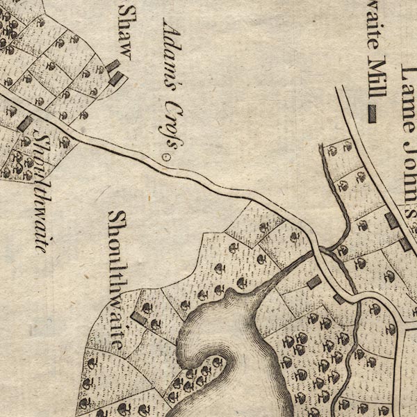 CL9NY31E.jpg item:- private collection : 10.9 Image © see bottom of page |
|||
|
|
||||
| evidence:- | old text:- Camden 1789 (Gough Additions) placename:- Bure, River |
|||
| source data:- | Book, Britannia, or A Chorographical Description of the Flourishing Kingdoms of England,
Scotland, and Ireland, by William Camden, 1586, translated from the 1607 Latin edition
by Richard Gough, published London, 1789. goto source Page 182:- "..." "On the north side of Castlerigg, on the river Bure, were lead and copper works, ruined in the civil war." |
|||
|
|
||||
| evidence:- | old map:- Cooper 1808 |
|||
| source data:- | Map, uncoloured engraving, Cumberland, scale about 10.5 miles to
1 inch, drawn and engraved by Cooper, published by R Phillips,
Bridge Street, Blackfriars, London, 1808. click to enlarge click to enlargeCOP3.jpg tapering wiggly line; river item:- JandMN : 86 Image © see bottom of page |
|||
|
|
||||
| evidence:- | old print:- Green 1814 (plate 27) |
|||
| source data:- | Print, tinted soft ground etching, Soskeld Bridge, St John's in the Vale, St John's
Castlerigg and Wythburn, Cumberland, by William Green, Ambleside, Westmorland, 1814.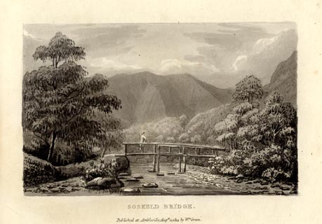 click to enlarge click to enlargeGN1027.jpg Sosgill Bridge on the St John's Beck. Plate 27 in Sixty Small Prints. printed at top right:- "27" printed at bottom:- "SOSKELD BRIDGE. / Published at Ambleside Augst. 1, 1814, by Wm. Green." item:- Armitt Library : A6653.27 Image © see bottom of page |
|||
|
|
||||
| evidence:- | old print:- Green 1814 (plate 27) |
|||
| source data:- | Print, uncoloured soft ground etching, Soskeld Bridge, St John's in the Vale, St John's
Castlerigg and Wythburn, Cumberland, by William Green, Ambleside, Westmorland, 1814.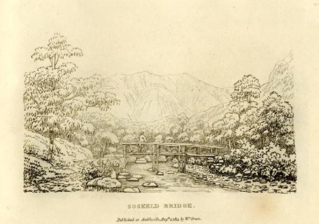 click to enlarge click to enlargeGN0927.jpg Sosgill Bridge on the St John's Beck. Plate 27 in Sixty Small Prints. printed at top right:- "27" printed at bottom:- "SOSKELD BRIDGE. / Published at Ambleside Augst. 1, 1814, by Wm. Green." item:- Armitt Library : A6656.27 Image © see bottom of page |
|||
|
|
||||
| evidence:- | old text:- Green 1814 placename:- Greta, River |
|||
| source data:- | Set of prints, soft ground etchings, Sixty Small Prints, with
text, A Description of a Series of Sixty Small Prints, by
William Green, Ambleside, Westmorland, 1814. goto source page 15:- "..." "Soskeld Bridge is upon the Greta, about a mile below the Keswick road. ..." |
|||
|
|
||||
| evidence:- | old map:- Otley 1818 |
|||
| source data:- | Map, uncoloured engraving, The District of the Lakes,
Cumberland, Westmorland, and Lancashire, scale about 4 miles to
1 inch, by Jonathan Otley, 1818, engraved by J and G Menzies,
Edinburgh, Scotland, published by Jonathan Otley, Keswick,
Cumberland, et al, 1833.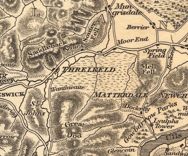 OT02NY32.jpg item:- JandMN : 48.1 Image © see bottom of page |
|||
|
|
||||
| evidence:- | descriptive text:- Otley 1823 (5th edn 1834) placename:- Bure, River |
|||
| source data:- | Guide book, A Concise Description of the English Lakes, the
mountains in their vicinity, and the roads by which they may be
visited, with remarks on the mineralogy and geology of the
district, by Jonathan Otley, published by the author, Keswick,
Cumberland now Cumbria, by J Richardson, London, and by Arthur
Foster, Kirkby Lonsdale, Cumbria, 1823; published 1823-49,
latterly as the Descriptive Guide to the English Lakes. goto source Page 40:- "..." "The river issuing from Thirlmere, commonly called St. John's beck, has formerly been called the Bure ..." |
|||
|
|
||||
| evidence:- | old map:- Garnett 1850s-60s H |
|||
| source data:- | Map of the English Lakes, in Cumberland, Westmorland and
Lancashire, scale about 3.5 miles to 1 inch, published by John
Garnett, Windermere, Westmorland, 1850s-60s.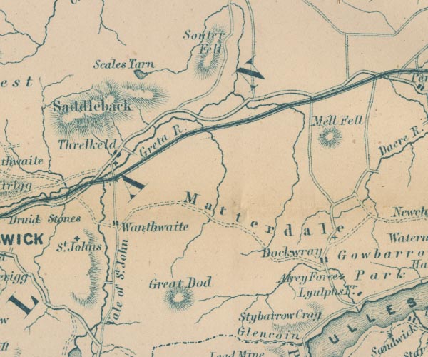 GAR2NY32.jpg wiggly line, river item:- JandMN : 82.1 Image © see bottom of page |
|||
|
|
||||
| evidence:- | old photograph:- Bell 1880s-1940s |
|||
| source data:- | Photograph, black and white, St John's Beck, looking towards Saddleback, St John's
Castlerigg and Wythburn, Cumberland, by Herbert Bell, photographer, Ambleside, Westmorland,
1890s.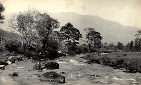 click to enlarge click to enlargeHB0745.jpg internegative at lower left:- "H. Bell" item:- Armitt Library : ALPS408 Image © see bottom of page |
|||
|
|
||||
| evidence:- | old photograph:- Bell 1880s-1940s |
|||
| source data:- | Photograph, sepia, St John's Beck, St John's Castlerigg and Wythburn, Cumberland,
by Herbert Bell, photographer, Ambleside, Westmorland, 1890s.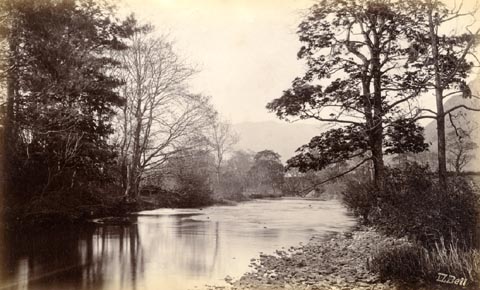 click to enlarge click to enlargeHB0744.jpg internegative at lower right:- "H. Bell" item:- Armitt Library : ALPS407 Image © see bottom of page |
|||
|
|
||||
| evidence:- | old photograph:- Bell 1880s-1940s |
|||
| source data:- | Photograph, black and white, Smaithwaite Bridge, Castle Rock, etc, St John's Castlerigg
and Wythburn, Cumberland, by Herbert Bell, photographer, Ambleside, Westmorland, 1890s.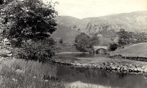 click to enlarge click to enlargeHB0717.jpg internegative at lower left:- "H. Bell" item:- Armitt Library : ALPS381 Image © see bottom of page |
|||
|
|
||||
| evidence:- | text:- Mason 1907 (edn 1930) placename:- Greta, River |
|||
| source data:- | Text book, The Ambleside Geography Books bk.III, The Counties of
England, by Charlotte M Mason, published by Kegan Paul, Trench,
Trubner and Co, Broadway House, 68-74 Carter Lane, and the
Parents' Educational Union Office, 26 Victoria Street, London,
edn 1930. MSN1P021.txt Page 21:- "..." "At the head of Thirlmere the road turns, and we get a peep down the sweet Vale of St. John's, watered by the Greta river. ..." |
|||
|
|
||||
| places:- |
|
|||
|
||||
|
||||
|
||||
|
||||
|
||||
|
||||
|
||||
|
||||
Lakes Guides menu.