 Old Cumbria Gazetteer
 |
 |
|
| Stockhow Hall, Lamplugh | ||
| Stockhow Hall | ||
| civil parish:- | Lamplugh (formerly Cumberland) | |
| county:- | Cumbria | |
| locality type:- | buildings | |
| coordinates:- | NY06541675 | |
| 1Km square:- | NY0616 | |
| 10Km square:- | NY01 | |
|
|
||
| evidence:- | old map:- OS County Series (Cmd 68 6) placename:- Stockhow Hall |
|
| source data:- | Maps, County Series maps of Great Britain, scales 6 and 25
inches to 1 mile, published by the Ordnance Survey, Southampton,
Hampshire, from about 1863 to 1948. |
|
|
|
||
| evidence:- | old map:- Donald 1774 (Cmd) placename:- Stocka Hall |
|
| source data:- | Map, hand coloured engraving, 3x2 sheets, The County of Cumberland, scale about 1
inch to 1 mile, by Thomas Donald, engraved and published by Joseph Hodskinson, 29
Arundel Street, Strand, London, 1774.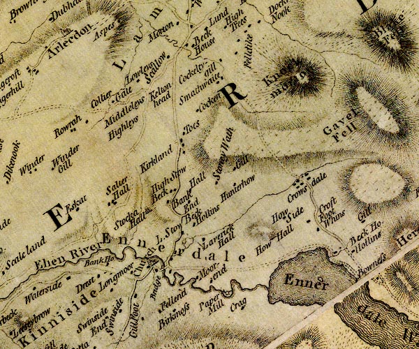 D4NY01NE.jpg "Stocka Hall" house item:- Carlisle Library : Map 2 Image © Carlisle Library |
|
|
|
||
| evidence:- | descriptive text:- Ford 1839 (3rd edn 1843) placename:- Stockhow Hall |
|
| source data:- | Guide book, A Description of Scenery in the Lake District, by
Rev William Ford, published by Charles Thurnam, Carlisle, by W
Edwards, 12 Ave Maria Lane, Charles Tilt, Fleet Street, William
Smith, 113 Fleet Street, London, by Currie and Bowman,
Newcastle, by Bancks and Co, Manchester, by Oliver and Boyd,
Edinburgh, and by Sinclair, Dumfries, 1839. goto source goto sourcePage 170:- "..." "Ennerdale Bridge.- Descending the hill to this place, is Stockhow Hall, whence there is a pretty view of the fertile vale of Ennerdale, and of the" goto sourcePage 171:- "lake stretching up to the high mountains." |
|
|
|
||
Lakes Guides menu.