 |
 |
|
|
|
|
|
|
|
Strickland Roger |
| county:- |
Cumbria |
| old county:- |
Westmorland |
| locality type:- |
parish |
| 1Km square:- |
SD5098 |
| 10Km square:- |
NY40 |
| 10Km square:- |
NY50 |
| 10Km square:- |
SD49 |
| 10Km square:- |
SD59 |
| references:- |
OS 1974 Admin Areas
|
|
|
| evidence:- |
hearth tax returns:- Hearth Tax 1675
placename:- Strickland Roger and Kettle
|
| source data:- |
Records, hearth tax survey returns, Westmorland, 1674/75.
"Strickland Roger and Kettle"
|
|
|
| evidence:- |
hearth tax returns:- Hearth Tax 1670
placename:- Stricklandfield
|
| source data:- |
Records, hearth tax returns, exchequer duplicates, Westmorland,
1670.
"Stricklandfield"
|
|
|
| evidence:- |
old map:- Jefferys 1770 (Wmd)
placename:- Strickland Roger
|
| source data:- |
Map, 4 sheets, The County of Westmoreland, scale 1 inch to 1
mile, surveyed 1768, and engraved and published by Thomas
Jefferys, London, 1770.
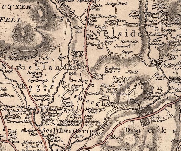
J5SD59NW.jpg
"Strickland Roger"
area
item:- National Library of Scotland : EME.s.47
Image © National Library of Scotland |
|
|
| evidence:- |
old map:- Cary 1789 (edn 1805)
placename:- Strickland Roger
|
| source data:- |
Map, uncoloured engraving, Westmoreland, scale about 2.5 miles
to 1 inch, by John Cary, London, 1789; edition 1805.
CY24SD59.jpg
"Strickland Roger"
area
item:- JandMN : 129
Image © see bottom of page
|
|
|
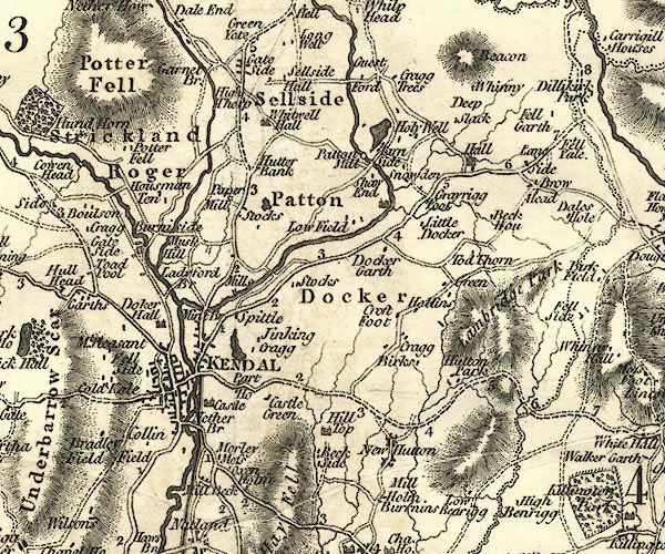
| evidence:- |
old map:- Cooper 1808
placename:- Strickland Roger
|
| source data:- |
Map, hand coloured engraving, Westmoreland ie Westmorland, scale
about 9 miles to 1 inch, by H Cooper, 1808, published by R
Phillips, Bridge Street, Blackfriars, London, 1808.
 click to enlarge click to enlarge
COP4.jpg
"Strickland Roger"
circle; village or hamlet
item:- Dove Cottage : 2007.38.53
Image © see bottom of page
|
|
|
| evidence:- |
census:- Census 1971
|
|
Population: 384 (1971) |
|
|
|
includes |
| place:- |
Stricklandfield Constablewick (N part of) |
|
| places:- |
 |
SD50039702 barn, Strickland Roger (2) |
|
|
|
SD51069692 Barnsdale, Strickland Roger |
|
|
|
SD51999772 Baxton Holme, Strickland Roger |
|
|
|
SD48789805 Beckmickle Ing, Strickland Roger |
|
|
|
SD51259718 Beetham Bank, Strickland Roger |
|
|
|
SD51329870 Birk Rigg, Strickland Roger |
|
|
|
SD50239687 Birkett Wood, Strickland Roger |
|
|
|
SD50869894 Birkriggs Wood, Strickland Roger |
|
|
|
SD50159911 boat house, Strickland Roger |
|
|
|
SD49879661 Bowston Bridge, Bowston L |
|
|
|
SD50339728 Braban House, Strickland Roger |
|
|
|
SD50529580 bridge, Burneside |
|
|
|
SD51679883 bridge, Strickland Roger |
|
|
|
NY4800 Brunt Knott Gill |
|
|
|
SD51039596 Burneside Hall, Burneside L |
|
|
|
SD51149576 Burneside Heads, Burneside |
|
|
|
SD51919913 Carl Crag, Strickland Roger |
|
|
|
SD50159732 Carlbank Lane, Strickland Roger |
|
|
|
SD50739521 Carling Steps, Burneside |
|
|
|
SD49759726 Chapeltree Wood, Strickland Roger |
|
|
|
SD503988 cock pit, Potter Fell |
|
|
|
SD52089966 Cocks Close, Garnett Bridge |
|
|
|
SD51869962 Cocks Close, Garnett Bridge (2) gone |
|
|
|
SD48879792 Cockshot Wood, Strickland Roger |
|
|
|
SD51339764 Cooper House, Strickland Roger |
|
|
|
SD50129725 Corn Hag, Strickland Roger |
|
|
|
SD52069960 dam, Garnett Bridge |
|
|
|
SD52069885 East View, Strickland Roger |
|
|
|
SD4998 Emanuel's Ghyll |
|
|
|
SD52079957 fence, Garnett Bridge |
|
|
|
SD49859761 fingerpost, Strickland Roger |
|
|
|
SD493979 Four Brothers Oak, Strickland Roger |
|
|
|
SD51429694 Garnett Bridge Road, Strickland Roger |
|
|
|
SD52089936 Garnett Bridge Wood, Garnett Bridge |
|
|
|
SD52369926 Garnett Bridge, Garnett Bridge L |
|
|
|
SD51849969 gate, Strickland Roger |
|
|
|
SD49709785 Ghyll Farm, Strickland Roger L |
|
|
|
SD49679847 Ghyll Pool, Strickland Roger |
|
|
|
SD50689774 Gilpin Bank, Strickland Roger |
|
|
|
SD49959785 Godmond Hall, Strickland Roger L |
|
|
|
SD52099752 Gurnal Bridge, Skelsmergh |
|
|
|
SD50319916 Gurnal Dubs, Strickland Roger |
|
|
|
SD49289782 Hagg Foot, Strickland Roger |
|
|
|
SD50249788 High House, Strickland Roger |
|
|
|
SD49279797 High Hundhowe, Strickland Roger L |
|
|
|
SD52149970 High Mill, Garnett Bridge |
|
|
|
SD50539939 High Taggleshaw, Strickland Roger |
|
|
|
SD51399776 High Underbrow, Strickland Roger |
|
|
|
SD51809757 Hill Farm, Strickland Roger |
|
|
|
SD51729768 Hill Fold, Strickland Roger |
|
|
|
SD51419912 Hole Slack, Strickland Roger |
|
|
|
SD51709836 Hollin Crag, Strickland Roger |
|
|
|
SD51249488 Ladyford Bridge, Skelsmergh |
|
|
|
SD50099700 Laithwaite Farm, Strickland Roger L |
|
|
|
SD51409787 Larchbank, Strickland Roger |
|
|
|
SD49489784 Low Hundhowe, Strickland Roger L |
|
|
|
SD50529888 Low Taggleshaw, Strickland Roger |
|
|
|
SD51879757 Low Underbrow, Strickland Roger |
|
|
|
SD50669927 Middle Taggleshaw, Strickland Roger |
|
|
|
SD52379920 Mill Cottage, Garnett Bridge L |
|
|
|
SD49849766 Mirefoot, Strickland Roger |
|
|
|
SD50409720 New House, Strickland Roger |
|
|
|
SD50729754 North Mint Well, Strickland Roger |
|
|
|
SD48959759 Oaks Wood, Strickland Roger |
|
|
|
SD4997 park, Cowan Head |
|
|
|
SD50999783 Potter Fell Road, Strickland Roger |
|
|
|
SD50849920 Potter Fell, Strickland Roger |
|
|
|
SD494989 Potter Tarn, Strickland Roger |
|
|
|
SD52359921 privy, Garnett Bridge |
|
|
|
SD51029902 Red Mires, Strickland Roger |
|
|
|
SD50539698 Robscott, Strickland Roger |
|
|
|
SD5198 Routen Beck |
|
|
|
SD52129856 Routen Wood, Strickland Roger |
|
|
|
SD51889794 Saul Hill, Strickland Roger |
|
|
|
SD51059618 sheep feeder, Strickland Roger |
|
|
|
SD51609873 sheepfold, Strickland Roger |
|
|
|
SD51109760 Shepherd Green, Strickland Roger |
|
|
|
SD48909854 Side House, Strickland Roger |
|
|
|
SD51589615 Sprint Mill, Strickland Roger |
|
|
|
SD51029610 Stephen's Oak, Burneside |
|
|
|
SD50009787 summer house, Strickland Roger |
|
|
|
SD532987 tarn, Selside |
|
|
|
SD51389643 Tenement Farm, Strickland Roger |
|
|
|
SD49929663 Thorncop, Bowston |
|
|
|
SD51119962 Ulgraves, Strickland Roger |
|
|
|
SD52069742 Underbrow Wood, Strickland Roger |
|
|
|
SD51139924 Upper Routenbeck Tarn, Strickland Roger |
|
|
|
SD51299754 Water House, Strickland Roger |
|
|
|
SD50569560 Burneside, Strickland Ketel |
|
|
|
SD5297 Baxenholme Mill, Strickland Roger gone |
|
|
|
SD52369924 bobbin mill, Garnett Bridge |
|
|
|
SD49599801 Ghyll Mill, Strickland Roger gone |
|
|
|
SD49869663 mill, Bowston gone |
|
|
|
SD49079782 mill, Strickland Roger |
|
|
|
SD52369922 Garnett Bridge, Strickland Roger |
|
|
|
NY4806 Sprint, River |
|
|
|
SD489986 Frost Hole Trials, Strickland Roger |
|
|
|
SD50559581 drinking fountain, Burneside |
|
|
|
NY4506 Kent, River |
|
|
|
SD49549873 barn, Strickland Roger |
|
|
|
SD51339603 Sprint Bridge, Strickland Roger |
|
