 Old Cumbria Gazetteer
 |
 |
|
| Swarth Fell, Martindale | ||
| Swarth Fell | ||
| civil parish:- | Martindale (formerly Westmorland) | |
| civil parish:- | Barton (formerly Westmorland) | |
| county:- | Cumbria | |
| locality type:- | hill | |
| locality type:- | fell | |
| coordinates:- | NY45091961 (etc) | |
| 1Km square:- | NY4519 | |
| 10Km square:- | NY41 | |
|
|
||
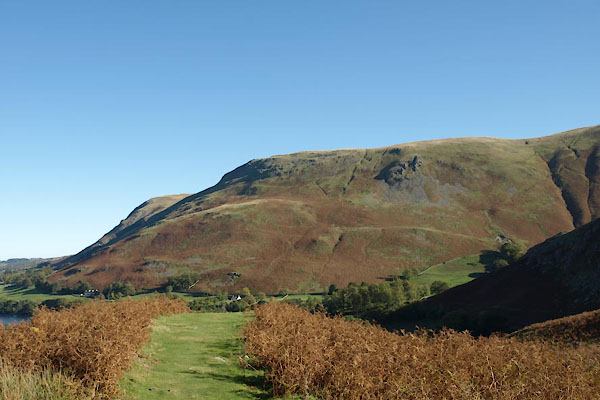 BTR65.jpg (taken 20.10.2010) |
||
|
|
||
| evidence:- | old map:- OS County Series (Wmd 13 2) placename:- Swarth Fell |
|
| source data:- | Maps, County Series maps of Great Britain, scales 6 and 25
inches to 1 mile, published by the Ordnance Survey, Southampton,
Hampshire, from about 1863 to 1948. |
|
|
|
||
| evidence:- | old map:- Jefferys 1770 (Wmd) placename:- Swarth Fell |
|
| source data:- | Map, 4 sheets, The County of Westmoreland, scale 1 inch to 1
mile, surveyed 1768, and engraved and published by Thomas
Jefferys, London, 1770.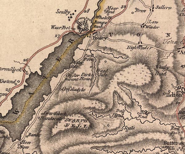 J5NY42SE.jpg "SWARTH FELL" hill hachuring; hill or mountain item:- National Library of Scotland : EME.s.47 Image © National Library of Scotland |
|
|
|
||
| evidence:- | old map:- Crosthwaite 1783-94 (Ull) placename:- Swarth Fell |
|
| source data:- | Map, uncoloured engraving, Accurate Map of the Beautiful Lake of
Ullswater, scale about 3 inches to 1 mile, by Peter Crosthwaite,
Keswick, Cumberland, 1783, version published 1800.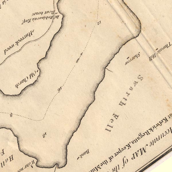 CT5NY42K.jpg "Swarth Fell" item:- Armitt Library : 1959.191.7 Image © see bottom of page |
|
|
|
||
| evidence:- | old map:- West 1784 map placename:- Swarth Fell |
|
| source data:- | Map, hand coloured engraving, A Map of the Lakes in Cumberland,
Westmorland and Lancashire, scale about 3.5 miles to 1 inch,
engraved by Paas, 53 Holborn, London, about 1784.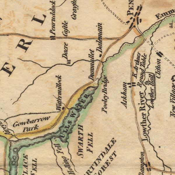 Ws02NY42.jpg "SWARTH FELL" item:- Armitt Library : A1221.1 Image © see bottom of page |
|
|
|
||
| evidence:- | old text:- Clarke 1787 placename:- Swarth Fell item:- fox hunt; hunting |
|
| source data:- | Guide book, A Survey of the Lakes of Cumberland, Westmorland,
and Lancashire, written and published by James Clarke, Penrith,
Cumberland, and in London etc, 1787; published 1787-93. goto source goto sourcePage 37:- "..." "Also look at the black, barren, and almost perpendicular mountain called Swarth-Fell: here your boatman will shew you the rock down which the late Edward Hassel, Esq; led his horse, that he might be in at the death of a fox; so steep and dangerous is the descent, that no one since that time durst ever attempt it, nor would any one give credit to it, were there not at this day many living witnesses of the desperate enterprize." |
|
|
|
||
| evidence:- | old print:- Clarke 1787 placename:- Swath Fell |
|
| source data:- | Topograph, the view from Penrith Beacon, Cumberland, by James
Clarke, published by James Clarke, London, 1787.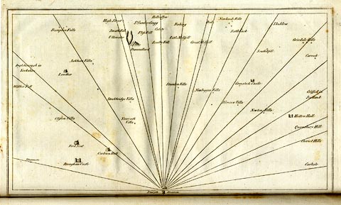 click to enlarge click to enlargeCL18.jpg "Swath Fell" item:- Armitt Library : A6615.12 Image © see bottom of page |
|
|
|
||
| evidence:- | old map:- Clarke 1787 map (Ullswater) placename:- Swath Fell |
|
| source data:- | Map, A Map of the Lake Ullswater and its Environs, scale about
6.5 ins to 1 mile, by James Clarke, engraved by S J Neele, 352
Strand, published by James Clarke, Penrith, Cumberland and in
London etc, 1787. CL4NY42K.jpg "a MOUNTAIN here called SWATH FELL" item:- private collection : 10.4 Image © see bottom of page |
|
|
|
||
| evidence:- | old map:- Cary 1789 (edn 1805) placename:- Swarth Fell |
|
| source data:- | Map, uncoloured engraving, Westmoreland, scale about 2.5 miles
to 1 inch, by John Cary, London, 1789; edition 1805. CY24NY42.jpg "Swarth Fell" hill hachuring item:- JandMN : 129 Image © see bottom of page |
|
|
|
||
| evidence:- | old map:- Otley 1818 placename:- Swarth Fell |
|
| source data:- | Map, uncoloured engraving, The District of the Lakes,
Cumberland, Westmorland, and Lancashire, scale about 4 miles to
1 inch, by Jonathan Otley, 1818, engraved by J and G Menzies,
Edinburgh, Scotland, published by Jonathan Otley, Keswick,
Cumberland, et al, 1833. OT02NY42.jpg item:- JandMN : 48.1 Image © see bottom of page |
|
|
|
||
| evidence:- | outline view:- Otley 1823 (4th edn 1830) placename:- Swarth Fell |
|
| source data:- | Print, engraving, outline view, The Mountains of Ullswater as seen from Pooley Bridge,
published by Jonathan Otley, Keswick, Cumberland et al, 1830.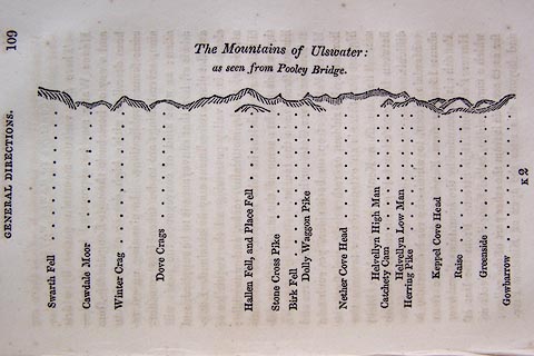 click to enlarge click to enlargeO75E05.jpg p.109 in A Concise Description of the English Lakes, by Jonathan Otley, 4th edition, 1830. "The Mountains of Ulswater: / as seen from Pooley Bridge." "Swarth Fell / Cawdale Moor / Winter Crag / Dove Crags / Hallen Fell, and Place Fell / Stone Cross Pike / Birk Fell / Dolly Waggon Pike / Nether Cove Head / Helvellyn High Man / Catchety Cam / Helvellyn Low Man / Herring Pike / Keppel Cove Head / Raise / Greenside / Gowbarrow" item:- Armitt Library : A1175.5 Image © see bottom of page |
|
|
|
||
| evidence:- | outline view:- Otley 1823 (8th edn 1849) placename:- Swarth End |
|
| source data:- | Engraving, outline view of mountains, Ullswater from Pooley Bridge, drawn by T Binns,
engraved by O Jewitt, opposite p.12 of A Descriptive Guide of the English Lakes, by
Jonathan Otley, 8th edition, 1849.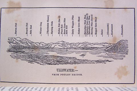 click to enlarge click to enlargeO80E07.jpg item:- Armitt Library : A1180.8 Image © see bottom of page |
|
|
|
||
| evidence:- | outline view:- Otley 1823 (5th edn 1834) |
|
| source data:- | Print, woodcut outline view, Mountains of Ullswater, by
Jonathan Otley, Keswick, Cumberland, 1830.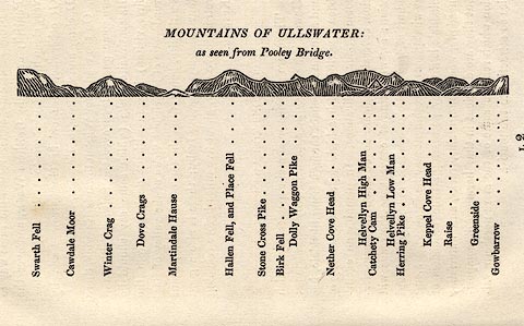 click to enlarge click to enlargeOT2E12.jpg Printed on p.113 of A Concise Description of the English Lakes, by Jonathan Otley, 5th edition, 1834. "MOUNTAINS OF ULLSWATER: as seen from Pooley Bridge." Mountains are listed:- "Swarth Fell / Cawdale Moor / Winter Crag / Dove Crags / Martindale Hause / Hallen Fell, and Place Fell / Stone Cross Pike / Birk Fell / Dolly Waggon Pike / Nether Cove Head / Helvellyn High Man / Catchety Cam / Helvellyn Low Man / Herring Pike / Keppel Cove Head / Raise / Greenside / Gowbarrow" item:- JandMN : 48.13 Image © see bottom of page |
|
|
|
||
| evidence:- | old map:- Garnett 1850s-60s H placename:- Swarth Fell |
|
| source data:- | Map of the English Lakes, in Cumberland, Westmorland and
Lancashire, scale about 3.5 miles to 1 inch, published by John
Garnett, Windermere, Westmorland, 1850s-60s. GAR2NY42.jpg "Swarth Fell" hill hachuring item:- JandMN : 82.1 Image © see bottom of page |
|
|
|
||
| evidence:- | old photograph:- Bogg 1898 placename:- Swarth Fell item:- reaping; harvest |
|
| source data:- | Photograph, halftone print, The Reapers, Swarth Fell, Martindale, Westmorland, by
Edmund Bogg, published by Edmund Bogg, 3 Woodhouse Lane, and James Miles, Guildford
Street, Leeds, Yorkshire, 1898.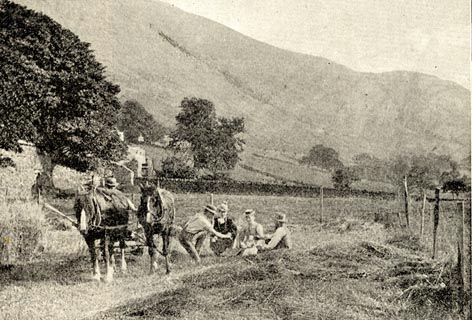 click to enlarge click to enlargeBGG141.jpg Included on p.141 of Lakeland and Ribblesdale, by Edmund Bogg. item:- JandMN : 231.41 Image © see bottom of page |
|
|
|
||
| evidence:- | outline view:- placename:- Swarth Fell |
|
| source data:- | Print, hand coloured engraving, Lower Reach, Ullswater from Pooley Bridge, Westmorland
and Cumberland, published by Sherwood and Co, London, 1836?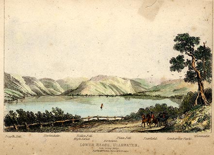 click to enlarge click to enlargePR0371.jpg Objects in the view are identified by a caption at the bottom - Swarth Fell, Martindale, High Street, Hallen Fell, Kirkstone, Place Fell, Fairfield, Gowbarrow Parks, Dumallet. printed at bottom:- "LOWER REACH, ULLSWATER. / from Pooley Bridge. / Pubd. April 15th 1836 by Sherwood &Co London." item:- Dove Cottage : 2008.107.371 Image © see bottom of page |
|
|
|
||
Lakes Guides menu.