 Old Cumbria Gazetteer
 |
 |
|
| Swinsto Hole, North Yorkshire | ||
| Swinsto Cave | ||
| site name:- | Gragareth | |
| county:- | North Yorkshire | |
| locality type:- | cave | |
| locality type:- | pothole | |
| coordinates:- | SD69387753 | |
| 1Km square:- | SD6977 | |
| 10Km square:- | SD67 | |
| altitude:- | 1260 feet | |
| altitude:- | 384m | |
| SummaryText:- | Explored by Yorkshire Ramblers Club; further by Gritstone Club, 1930; and University of Leeds Speleological Association, 1962. | |
| SummaryText:- | Grade IV; permission from Thornton Hall, Westhouse. | |
| references:- | Brook, D & Davies, G & Long, M H &Sutcliffe, J R: 1975: Northern Caves, vol.4 Whernside
and Gragareth: Dalesman Books:: ISBN 0 85206 259 1 |
|
|
|
||
| evidence:- | descriptive text:- Balderston c1890 placename:- Swinsto Hole item:- stalactite |
|
| source data:- | Book, Ingleton, Bygone and Present, by Robert R and Margaret
Balderston, published by Simpkin, Marshall and Co, London, and
by Edmndson and Co, 24 High Street, Skipton, Yorkshire, about
1890. goto source goto sourcepage 64:- "..." "Swinsto Hole, Shake Holes, and Thorney Pot." "Returning along the scar to the south of Rowantree Cave, the pedestrian may observe a long line of 'shake-holes' to his right hand, evidently indicating a prolonged fracture in the rocks. Beyond these is Swinsto Hole Sike, which loses itself amongst stones; but close to the left hand of the brook's extremity the stream may be seen running at some distance below, on peering through various fissures in the rock, at the last of which, it is observed to enter a cave very similar to the head of Rowantree Cavern, but with lower roof, and a small 'man-hole' in the ground, through which the adventurous cave-hunter must worm his way, feet foremost; having passed the aperture, as a thread through the eye of a needle, the reward for the labour is not, perhaps, so paltry as appearances would suggest. About seven yards from the mouth is a peculiar stalactitic partition, making the passage double, and twenty-six yards further is a deep wide hole, with high vaulted roof, fine cone-like stalactites, and waterfall thirty feet high. ..." |
|
|
|
||
| evidence:- | old map:- Balderston c1890 map placename:- Swinto Cave |
|
| source data:- | Map, the hills in the Ingleton area, probably by Robert R
Balderston, engraved by Goodall and Suddick, Leeds, West
Yorkshire, about 1890.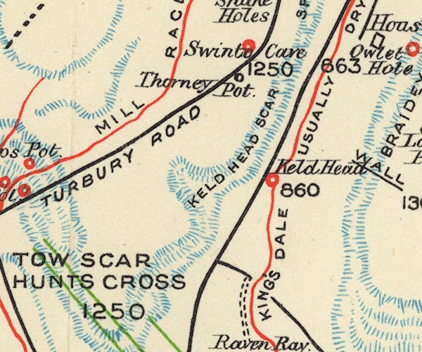 BS1SD67Y.jpg "Swinto Cave" item:- private collection : 27.1 Image © see bottom of page |
|
|
|
||
Lakes Guides menu.