 Old Cumbria Gazetteer
 |
 |
|
|
| Ulverstone and Lancaster Railway | |||
| Cumbrian Coast Line | |||
| civil parish:- | Ulverston (formerly Lancashire) | ||
| civil parish:- | Egton with Newland (formerly Lancashire) | ||
| civil parish:- | Lower Allithwaite (formerly Lancashire) | ||
| civil parish:- | Lower Holker (formerly Lancashire) | ||
| civil parish:- | Grange-over-Sands (formerly Lancashire) | ||
| civil parish:- | Meathop and Ulpha (formerly Westmorland) | ||
| civil parish:- | Arnside (formerly Westmorland) | ||
| county:- | Cumbria | ||
| locality type:- | railway | ||
| county:- | Lancashire | ||
| locality type:- | railway | ||
| SummaryText:- | from Ulverston on the Furness Railway, through Plumpton, Cark in Cartmel, Kent's Bank, Grange over Sands, Arnside, Silverdale, to Carnforth on the Lancaster and Carlisle Railway, Lancashire. | ||
| references:- | 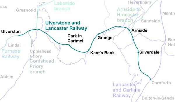 RWY011.jpg |
||
|
|
|||
 BLW36.jpg (taken 18.4.2006) |
|||
|
|
|||
| evidence:- | old map:- Garnett 1850s-60s H placename:- Midland Railway |
||
| source data:- | Map of the English Lakes, in Cumberland, Westmorland and
Lancashire, scale about 3.5 miles to 1 inch, published by John
Garnett, Windermere, Westmorland, 1850s-60s.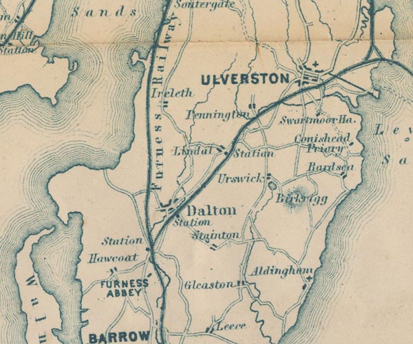 GAR2SD27.jpg triple line, light bold light, railway 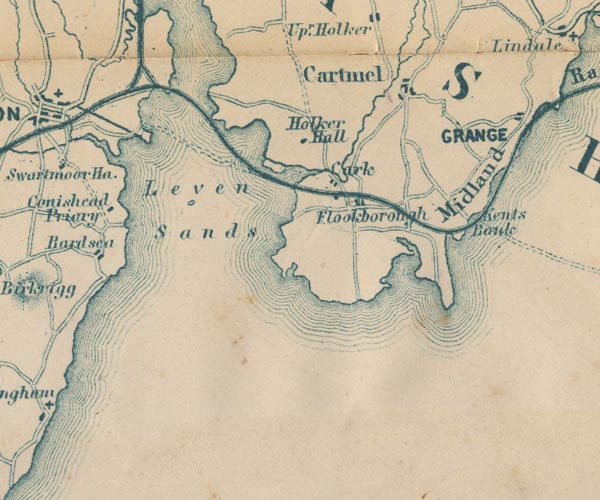 GAR2SD37.jpg "Midland Railway" note the triangular juntion with the Lakside branch; the route across Cartmel Sands is interesting 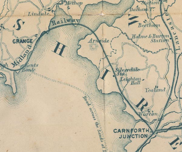 GAR2SD47.jpg item:- JandMN : 82.1 Image © see bottom of page |
||
|
|
|||
| evidence:- | old print:- Barber 1873 |
||
| source data:- | Print, ?colour lithograph, Grange, published by The Graphotyping
Co, 7 Garrick Street and Simpkin, Marshall and Co, Stationers'
Hall Court, London, and by J Atkinson, King Street, Ulverston,
Cumberland, about 1873.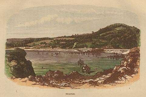 click to enlarge click to enlargeBB1E02.jpg Grange-over-Sands seen from Holme Island; there is a train on the Ulverstone and Lancaster Railway approaching the station. "GRANGE" item:- JandMN : 69.3 Image © see bottom of page |
||
|
|
|||
| evidence:- | old map:- LMS 1939 B |
||
| source data:- |  click to enlarge click to enlargeLMS6Cm.jpg "MAP OF LMS RAILWAY" item:- JandMN : 1016.5 Image © see bottom of page |
||
|
|
|||
| hearsay:- |
The railway was promoted by the Brogden Family. A route was surveyed by McLean and
Stileman, 1850. |
||
| 19½miles. |
|||
| The railway caused enormous changes to the northern shore of Morecambe Bay and the
Kent Estuary. From the openeing in 1859 up to the 1870s over 1100 acres of land were
reclaimed. Above the viaduct 700 acres of new marsh appeared as a result of silting,
some of which was reclaimed later. |
|||
| Gilpin, Leslie R: 2008: Ulverstone and Lancaster Railway: Cumbrian Railways Association::
ISBN 0 954232 7 0 |
|||
|
|
|||
| person:- | railway company : Ulverstone and Lancaster Railway |
||
| date:- | 1851 to 1862 |
||
|
|
|||
| person:- | railway company : Furness Railway; FR |
||
| date:- | 1862 to 1923 |
||
|
|
|||
| person:- | railway company : London, Midland and Scottish Railway; LMS |
||
| date:- | 1923 to 1948 |
||
|
|
|||
| person:- | railway company : British Railways; BR |
||
| date:- | 1948 |
||
|
|
|||
| goes through:- |  Ulverston Station, Ulverston railway bridge, Ulverston (3) railway bridge, Ulverston (4) railway bridge, Ulverston (5) railway bridge, Ulverston (6) railway bridge, Ulverston (8) railway viaduct, Ulverston Ulverston Station, Ulverston railway bridge, Ulverston (3) railway bridge, Ulverston (4) railway bridge, Ulverston (5) railway bridge, Ulverston (6) railway bridge, Ulverston (8) railway viaduct, Ulverston[railway bridge, Ulverston (2)] Next Ness Embankment, Egton with Newland Plumpton West Junction, Egton with Newland Plumpton East Junction, Egton with Newland railway bridge, Egton with Newland (3) Plumpton Gate, Egton with Newland Leven Junction, Egton with Newland railway bridge, Egton with Newland (4) wind pressure gauge, Leven Viaduct Leven Viaduct, Egton with Newland[railway bridge, Lower Holker] level crossing, Lower Holker[railway bridge, Cark (4)] [railway bridge, Cark (3)] [railway bridge, Cark (2)] railway bridge, Cark Cark and Cartmel Station, Cark railway bridge, Flookburgh Wraysholme Halt, Lower Allithwaite Wraysholme Crossing, Lower Allithwaite[railway bridge, Lower Allithwaite] level crossing, Kents Bank Kents Bank Station, Kents Bank railway bridge, Grange-over-Sands[railway crossing, Grange-over-Sands] level crossing, Grange-over-Sands (2) railway footbridge, Grange-over-Sands (2) Bayley Lane Crossing, Grange-over-Sands Grange-over-Sands Station, Grange-over-Sands signal box, Grange-over-Sands railway footbridge, Grange-over-Sands railway embankment, Grange-over-Sands level crossing, Grange-over-Sands[railway bridge, Meathop] Meathop Embankment, Meathop and Ulpha Kent Viaduct, Arnside signal box, Arnside Arnside Junction, Arnside Arnside Station, Arnside railway bridge, Arnside level crossing, Arnside Black Dyke Crossing, Arnside[railway bridge, Arnside (2)] Silverdale Station, Lancashire Carnforth Station, Lancashire (2) Carnforth Station, Lancashire Carnforth Junction, Lancashire24.7.1851: authorized - 1857: opened - |
||
|
|
|||
Lakes Guides menu.