 Old Cumbria Gazetteer
 |
 |
|
||
| Walney Channel | ||||
| civil parish:- | Barrow-in-Furness (formerly Lancashire) | |||
| county:- | Cumbria | |||
| locality type:- | river | |||
| locality type:- | channel | |||
| 1Km square:- | SD1967 (etc) | |||
| 10Km square:- | SD16 | |||
|
|
||||
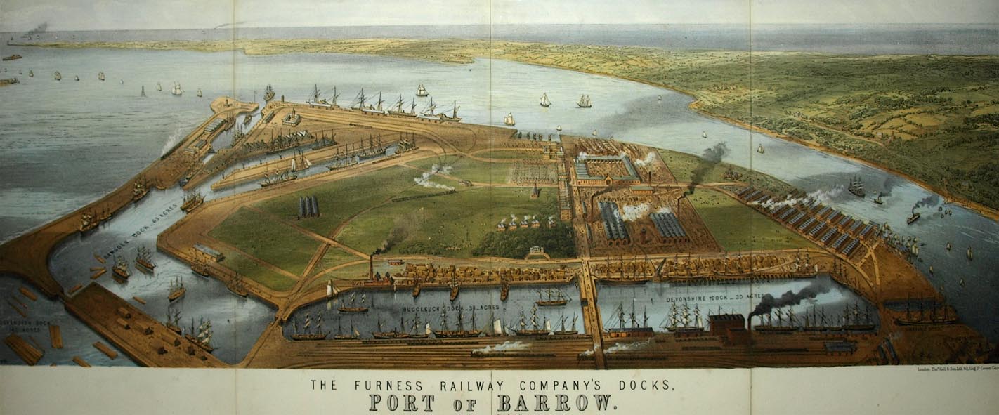 click to enlarge click to enlargeBPS81.jpg Aerial view. "THE FURNESS RAILWAY COMPANY'S DOCKS. / PORT OF BARROW." courtesy the Dock Museum |
||||
|
|
||||
| evidence:- | old map:- OS County Series (Lan 15 15) placename:- Walney Channel |
|||
| source data:- | Maps, County Series maps of Great Britain, scales 6 and 25
inches to 1 mile, published by the Ordnance Survey, Southampton,
Hampshire, from about 1863 to 1948. OS County Series (Lan 21 11) OS County Series (Lan 21 15) OS County Series (Lan 27 4) |
|||
|
|
||||
| evidence:- | old map:- Garnett 1850s-60s H |
|||
| source data:- | Map of the English Lakes, in Cumberland, Westmorland and
Lancashire, scale about 3.5 miles to 1 inch, published by John
Garnett, Windermere, Westmorland, 1850s-60s.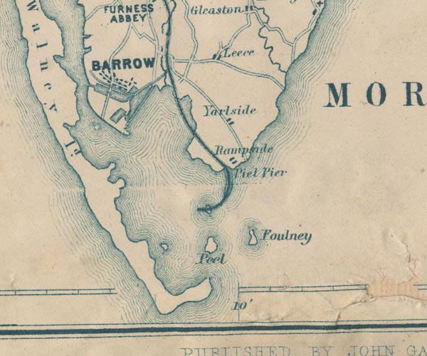 GAR2SD26.jpg area item:- JandMN : 82.1 Image © see bottom of page |
|||
|
|
||||
| evidence:- | old text:- Admiralty 1933 item:- dredger; navigation lights; buoy, Barrow Docks; fog signal |
|||
| source data:- |  goto source goto sourcePage 376:- "Entrance channel. - Depths. - Sandflats, with depths of less than 3 fathoms (5m5) over them, extend about 2 1/2 miles south-south-westward from Hilpsford point, the south-western point of Walney island and northern point of the entrance to Morecambe bay." goto sourcePage 377:- "A least depth of 3 3/4 feet (1m1) is maintained by dredging in a channel, 400 feet (121m9) wide, between Piel harbour and the docks." "Winds. - Caution. - South-westerly and westerly winds, which cause considerable sea in the entrance channel, are the most dangerous winds." "Strong south-westerly and westerly gales increase the depths in Walney channel; easterly winds have the opposite effect." "Dredging. - Signals. - Dredging is generally in progress in the channel between Piel harbour and the docks." "A black ball is displayed, by day, on the side of the dredger which is clear for vessels to pass; at night, three white lights are exhibited in the form of a triangle, and a fourth white light 6 feet (1m8) below one angle of the triangle, on the side which is clear for vessels to pass." "The ordinary fog signal for a vessel not under way is sounded when required." "Vessels should pass the dredger at a moderate speed." "Lights. - Beacons. - A light is exhibited, at an elevation of 70 feet (21m3), from a stone tower, 60 feet (18m3) in height, situated about 1 3/4 cables north-westward of South East point, Walney island." "..." Page 378:- "..." "Buoyage. - The approaches to Barrow docks are buoyed in accordance with the uniform system of buoyage for the United Kingdom, described on page 21, the colour of the starboard hand buoys being red, and of port buoys black." goto sourcePage 379:- "..." "..." "In the channel abreast Devonshire dock, the stream runs northward for about 1 3/4 hours after high water at Liverpool. About three-quarters of an hour before high water at Liverpool, the tidal stream is comparatively slack for half an hour, and then runs again northward with great force, and, unlike that in front of Ramsden dock, reaches its maximum velocity about half an hour after high water at Liverpool, gradually decreasing in force until it turns southward." "Strong south-westerly and westerly gales increase the strength of the streams in Walney channel; easterly winds have the opposite effect." "..." goto sourcePage 380:- "..." "If proceeding to the docks, and having ascertained that the dock gates are open (see "Signals" at page 382), steer up the channel with Nos.5 and 6 light-beacons in line, bearing 298~, until nearly abreast of East pile, whence the buoyed channel must be followed." "Regulations. - Bye-laws are in force and masters of vessels should make themselves acquainted with them immediately on arrival; copies may be procured from the Harbour Master." "The Master of every Petroleum vessel shall, on nearing the harbour (which includes Piel harbour and Barrow docks), and during the time the vessel remains in harbour, display by day a red flag not less than 3 feet (0m9) square, and by night a red light on the masthead (or, if the vessel has no mast, on a staff). The master shall moor the ship in any place that the Harbour Master may direct, and shall not shift berth without permission, except to proceed to sea." "Vessels arriving before tide time are prohibited from anchoring opposite the entrance to Ramsden basin, or from going alongside the pierhead before the gates are open." "Wharves. - Pier. - Light. - Ramsden Dock Station wharf extends 830 feet (253m0) along the north-eastern side of Walney channel, from a position a short distance northward of the entrance to Ramsden Dock basin; there are berths alongside this wharf with depths of 12 feet (3m7) alongside." "Deep Water berth lies on the north-eastern side of the channel, northward of Ramsden Dock wharf; it is 850 feet (259m1) long and 100 feet (30m5) wide, with depths of 33 feet (10m1)." "Harbour Yard pier extends about a cable south-westward from a position about 4 1/4 cables north-westward of the entrance to Ramsden Dock basin; it is 50 feet (15m2) wide and carries a light railway. A light is exhibited from the pierhead." "Walney bridge. ..." |
|||
|
|
||||
| places:- |
|
|||
|
||||
|
||||
|
||||
Lakes Guides menu.