 Old Cumbria Gazetteer
 |
 |
|
| White Side, St John's Castlerigg etc | ||
| White Side | ||
| civil parish:- | St John's Castlerigg and Wythburn (formerly Cumberland) | |
| county:- | Cumbria | |
| coordinates:- | NY332170 (etc) | |
| 1Km square:- | NY3317 | |
| 10Km square:- | NY31 | |
|
|
||
| evidence:- | outline view:- Matthew 1866 placename:- White Side |
|
| source data:- | Print, engraving, outline view, Helvellyn from above Harrop Tarn, Poney Road from
Wythburn to Whatendlath and Borrowdale, Cumberland, published by J Richardson, Highgate,
Kendal, Westmorland, 1866.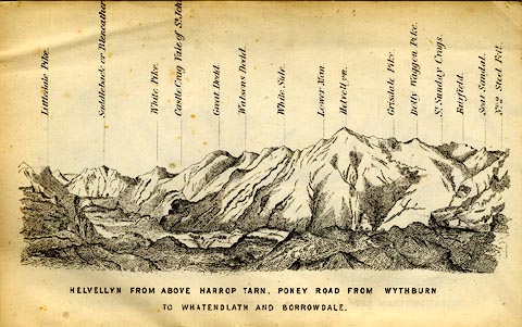 click to enlarge click to enlargeMW1E02.jpg Tipped in before p.1 of The English Lakes, Peaks and Passes, from Kendal to Keswick, by George King Matthew. printed at bottom:- "HELVELLYN FROM ABOVE HARROP TARN, PONEY ROAD FROM WYTHBURN TO WHATENDLATH AND BORROWDALE." printed at caption to mountains:- "... White Side. ..." item:- Armitt Library : A1168.2 Image © see bottom of page |
|
|
|
||
 Lakes Guides menu.