 Old Cumbria Gazetteer
 |
 |
|
| Yeorton, St John Beckermet | ||
| Yeorton | ||
| Yeorton Hall Farm | ||
| civil parish:- | St John Beckermet (formerly Cumberland) | |
| county:- | Cumbria | |
| locality type:- | buildings | |
| coordinates:- | NY02650778 | |
| 1Km square:- | NY0207 | |
| 10Km square:- | NY00 | |
|
|
||
| evidence:- | old map:- OS County Series (Cmd 72 16) placename:- Yeorton |
|
| source data:- | Maps, County Series maps of Great Britain, scales 6 and 25
inches to 1 mile, published by the Ordnance Survey, Southampton,
Hampshire, from about 1863 to 1948. |
|
|
|
||
| evidence:- | old map:- OS County Series placename:- Yeorton |
|
| source data:- | Maps, County Series maps of Great Britain, scales 6 and 25
inches to 1 mile, published by the Ordnance Survey, Southampton,
Hampshire, from about 1863 to 1948. "Yeorton" |
|
|
|
||
| evidence:- | old map:- Donald 1774 (Cmd) placename:- Yarton |
|
| source data:- | Map, hand coloured engraving, 3x2 sheets, The County of Cumberland, scale about 1
inch to 1 mile, by Thomas Donald, engraved and published by Joseph Hodskinson, 29
Arundel Street, Strand, London, 1774.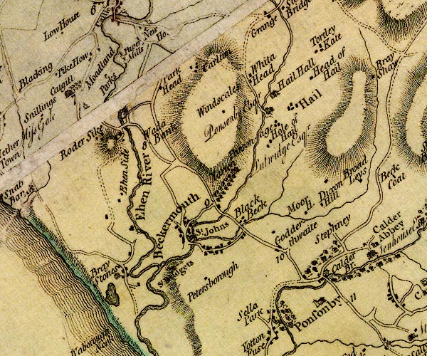 D4NY00NW.jpg "Yarton" house and avenue of trees item:- Carlisle Library : Map 2 Image © Carlisle Library |
|
|
|
||
| evidence:- | database:- Listed Buildings 2010 placename:- Yeorton Farm |
|
| source data:- | courtesy of English Heritage "YEORTON FARMHOUSE / / / ST JOHN BECKERMET / COPELAND / CUMBRIA / II / 76368 / NY0266907774" |
|
|
|
||
| evidence:- | database:- Listed Buildings 2010 |
|
| source data:- | courtesy of English Heritage "GATEPIERS AND WALL TO SOUTH WEST OF YEORTON FARM / / / ST JOHN BECKERMET / COPELAND / CUMBRIA / II / 76369 / NY0266107764" |
|
|
|
||
 Lakes Guides menu.