 Old Cumbria Gazetteer
 |
 |
|
| Yewthwaite Mine, Above Derwent | ||
| Yewthwaite Mine | ||
| locality:- | Yewthwaite Comb | |
| locality:- | Newlands Valley | |
| civil parish:- | Above Derwent (formerly Cumberland) | |
| county:- | Cumbria | |
| locality type:- | mine | |
| locality type:- | lead mine | |
| coordinates:- | NY23961941 (about) | |
| 1Km square:- | NY2319 | |
| 10Km square:- | NY21 | |
| references:- | Adams, John: 1988: Mines of the Lake District Fells: Dalesman Books (Lancaster, Lancashire)::
ISBN 0 85206 931 6 |
|
|
|
||
| evidence:- | old map:- OS County Series (Cmd 64 13) |
|
| source data:- | Maps, County Series maps of Great Britain, scales 6 and 25
inches to 1 mile, published by the Ordnance Survey, Southampton,
Hampshire, from about 1863 to 1948. "Lead Mines / Level / ..." |
|
|
|
||
| evidence:- | old text:- Postlethwaite 1877 (3rd edn 1913) placename:- Yewthwaite Mine item:- lead ore; galena; cerussite; blende; iron pyrites |
|
| source data:- | Book, Mines and Mining in the English Lake District, by John Postlethwaite, Keswick,
published by W H Moss and Sons, Whitehaven, Cumberland now Cumbria, 1877; published
1877-1913. goto source goto sourcepage 86:- "YEWTHWAITE MINE." "Is situated on the north-western side of Catbells, near the junction of that mountain with Maiden Moor. The bearing of the vein is due north and south, and its hade is towards the east. The ores which it yields are Galena, Cerussite (some very fine specimens of the latter mineral have been found in it), Blende and Iron Pyrites." "This vein also is intersected about the middle of the ore-bearing ground, by a dyke of igneous rock, which is no doubt a continuation of the one at Brandlehow Mine, although it cannot be clearly traced through the intervening distance, owing to the quantity of surface soil and turf. The distance between the Brandlehow and Yewthwaite veins is about half a mile." "There is no record to show when this mine was first worked, but in all probability it was not earlier than the latter part of the Eighteenth Century. Like many other mines in the district, Yewthwaite has been extensively wrought at the surface by men possessing little or no capital, but who managed, nevertheless, to earn a living by digging into the veins wherever there was sufficient ore to repay their labour. But as they possessed no machinery, either for pumping or drawing, they were often unable to sink more than three or four fathoms below the surface. Some of the deposits of ore which had been discovered and wrought in this way, in Yewthwaite, by the old men, were considered too good to be abandoned, and a flank level was driven, for the purpose of" goto sourcepage 88:- "cutting them at a greater depth. After reaching the vein, the level had been continued southward for a considerable distance, and a good deal of orey ground headed out. This level was re-opened by Messrs. Clarke &Co., in 1849, and up to the end of November, 1850, 35 tons of ore were raised from it. Mr. Clarke, who acted as manager, commenced driving northward from the point where the vein was cut; a course which few practical miners would have adopted, because, owing to the form of the ground, his men could only drive a few fathoms until they would again break through to the surface; but Mr. Clarke seems to have been favoured with an extraordinary amount of what is commonly called "good luck," and it so happened that in those few fathoms, a valuable deposit of ore was found; but as the ore at Goldscope was discovered shortly after, Yewthwaite was neglected, and all attention bestowed upon its more wealthy rival. A few years later, however, another flank level, called the "trustee's level," was driven by Mr. Clarke's Trustees, 24 fathoms below the former, and the ground above headed out; a shaft was then sunk to the depth of 30 fathoms, and three sets of levels driven off, from which large quantities of ore were raised." "After the mine had been successfully wrought by Mr. Clarke and his Trustees, for upwards of twenty years, it was again sold, to Mr. H. K. Spark, of Darlington, who continued operations for a few years, but not with the same vigour as the former proprietors." "The length of the orey ground is about 130 fathoms; and for many years, when the mine was most prosperous, it yielded about 420 tons of ore per annum, worth about L5,880; while the working expenses would scarcely exceed half that sum." |
|
|
|
||
| evidence:- | old map:- Postlethwaite 1877 (3rd edn 1913) placename:- Yewthwaite Mine |
|
| source data:- | Map, uncoloured engraving, Map of the Lake District Mining Field, Westmorland, Cumberland,
Lancashire, scale about 5 miles to 1 inch, by John Postlethwaite, published by W H
Moss and Sons, 13 Lowther Street, Whitehaven, Cumberland, 1877 edn 1913.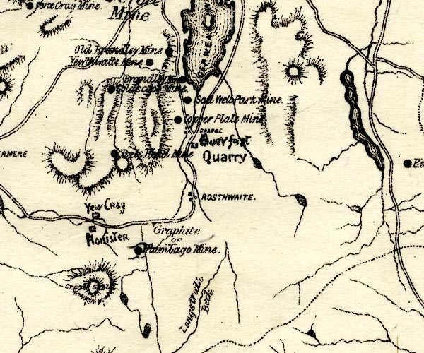 PST2NY21.jpg "Yewthwaite Mine" mine symbol item:- JandMN : 162.2 Image © see bottom of page |
|
|
|
||
| evidence:- | mine plan:- Postlethwaite 1877 placename:- Yewthwaite Mine |
|
| source data:- | Print, drawing, mine section, Section of Yewthwaite Mine, Above Derwent, Cumberland,
scale about 1 to 2900, by John Postlethwaite, published by W H Moss and Sons, 13 Lowther
Street, Whitehaven, Cumberland, 1877 edn 1913.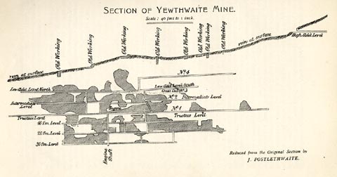 click to enlarge click to enlargePST317.jpg On p.87 of Mines and Mining in the English Lake District, by John Postlethwaite. printed, upper centre "SECTION OF YEWTHWAITE MINE. / Scale: 40 fms to 1 inch." printed, lower right "Reduced from the Original Section by / J. POSTLETHWAITE." item:- JandMN : 162.19 Image © see bottom of page |
|
|
|
||
| evidence:- | old text:- Postlethwaite 1877 (3rd edn 1913) placename:- Yewthwaite Mine item:- lead ore; galena; cerussite; blende; iron pyrites |
|
| source data:- | Book, Mines and Mining in the English Lake District, by John Postlethwaite, Keswick,
published by W H Moss and Sons, Whitehaven, Cumberland now Cumbria, 1877; published
1877-1913. goto source page 86:- "YEWTHWAITE MINE." "Is situated on the north-western side of Catbells, near the junction of that mountain with Maiden Moor. The bearing of the vein is due north and south, and its hade is towards the east. The ores which it yields are Galena, Cerussite (some very fine specimens of the latter mineral have been found in it), Blende and Iron Pyrites." "This vein also is intersected about the middle of the ore-bearing ground, by a dyke of igneous rock, which is no doubt a continuation of the one at Brandlehow Mine, although it cannot be clearly traced through the intervening distance, owing to the quantity of surface soil and turf. The distance between the Brandlehow and Yewthwaite veins is about half a mile." "There is no record to show when this mine was first worked, but in all probability it was not earlier than the latter part of the Eighteenth Century. Like many other mines in the district, Yewthwaite has been extensively wrought at the surface by men possessing little or no capital, but who managed, nevertheless, to earn a living by digging into the veins wherever there was sufficient ore to repay their labour. But as they possessed no machinery, either for pumping or drawing, they were often unable to sink more than three or four fathoms below the surface. Some of the deposits of ore which had been discovered and wrought in this way, in Yewthwaite, by the old men, were considered too good to be abandoned, and a flank level was driven, for the purpose of" goto sourcepage 88:- "cutting them at a greater depth. After reaching the vein, the level had been continued southward for a considerable distance, and a good deal of orey ground headed out. This level was re-opened by Messrs. Clarke &Co., in 1849, and up to the end of November, 1850, 35 tons of ore were raised from it. Mr. Clarke, who acted as manager, commenced driving northward from the point where the vein was cut; a course which few practical miners would have adopted, because, owing to the form of the ground, his men could only drive a few fathoms until they would again break through to the surface; but Mr. Clarke seems to have been favoured with an extraordinary amount of what is commonly called "good luck," and it so happened that in those few fathoms, a valuable deposit of ore was found; but as the ore at Goldscope was discovered shortly after, Yewthwaite was neglected, and all attention bestowed upon its more wealthy rival. A few years later, however, another flank level, called the "trustee's level," was driven by Mr. Clarke's Trustees, 24 fathoms below the former, and the ground above headed out; a shaft was then sunk to the depth of 30 fathoms, and three sets of levels driven off, from which large quantities of ore were raised." "After the mine had been successfully wrought by Mr. Clarke and his Trustees, for upwards of twenty years, it was again sold, to Mr. H. K. Spark, of Darlington, who continued operations for a few years, but not with the same vigour as the former proprietors." "The length of the orey ground is about 130 fathoms; and for many years, when the mine was most prosperous, it yielded about 420 tons of ore per annum, worth about L5,880; while the working expenses would scarcely exceed half that sum." |
|
|
|
||
| evidence:- | old map:- Postlethwaite 1877 (3rd edn 1913) placename:- Yewthwaite Mine |
|
| source data:- | Map, uncoloured engraving, Map of the Lake District Mining Field, Westmorland, Cumberland,
Lancashire, scale about 5 miles to 1 inch, by John Postlethwaite, published by W H
Moss and Sons, 13 Lowther Street, Whitehaven, Cumberland, 1877 edn 1913. PST2NY21.jpg "Yewthwaite Mine" mine symbol item:- JandMN : 162.2 Image © see bottom of page |
|
|
|
||
| evidence:- | mine plan:- Postlethwaite 1877 placename:- Yewthwaite Mine |
|
| source data:- | Print, drawing, mine section, Section of Yewthwaite Mine, Above Derwent, Cumberland,
scale about 1 to 2900, by John Postlethwaite, published by W H Moss and Sons, 13 Lowther
Street, Whitehaven, Cumberland, 1877 edn 1913. click to enlarge PST317.jpg On p.87 of Mines and Mining in the English Lake District, by John Postlethwaite. printed, upper centre "SECTION OF YEWTHWAITE MINE. / Scale: 40 fms to 1 inch." printed, lower right "Reduced from the Original Section by / J. POSTLETHWAITE." item:- JandMN : 162.19 Image © see bottom of page |
|
|
|
||
| evidence:- | visit log:- KDMRS 1979-82 placename:- Yewthwaite Mines item:- galena; copper pyrites; blende |
|
| source data:- | Notes, log book of Geological Outings, mine plans, etc, Kendal
and District Mine Research Society, Kendal area, Cumbria, etc,
visits made 1979-82. Geological Outing of the Kendal and District Mine Research Society Log book page 101:- "DATE - 23/8/81 / MAP REF - 2415/1925 / LOCATION - BRUNT CRAGS / NAME - YEWTHWAITE MINES. / TYPE OF SITE - MINES / WORKING OR DISUSED - DISUSED. / PEOPLE IN PARTY [ ] / NOS. OF PHOTOS - 57 / SPECIMENS FOUND - GALENA COPPER PYRITES &BLENDE / COMMENTS - HOT DRY DAY. EXTENSIVE SPOIL HEAPS AND SOME INDICATIONS OF WHERE LEVELS ONCE EXISTED. ONLY ONE LEVEL LEFT OPEN AND THIS IS ONLY SHORT BEING SOME 40YDS IN LENGTH AND HAVING A SMALL SHAFT IN ITS FLOOR." item:- private collection : 82 Image © see bottom of page |
|
|
|
||
| evidence:- | mine drawing:- KDMRS 1979-82 |
|
| source data:- | Geological Outing of the Kendal and District Mine Research Society to Yewthwaite Mine,
Above Derwent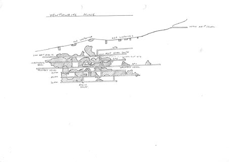 click to enlarge click to enlargeKMR41.jpg "YEWTHWAITE MINE" item:- private collection : 82 Image © see bottom of page |
|
|
|
||
| :- |
Lead mine on the west flank of Cat Bells. Nothing known before 1849; abandoned 1893. |
|
| Yewthwaite Vein, argentiferous galena, cerussite, and blende in quartz; and extension
of the Goldscope Copper Lode. |
||
| Adams, John: 1988: Mines of the Lake District Fells: Dalesman Books (Lancaster, Lancashire)::
ISBN 0 85206 931 6 |
||
|
|
||
Lakes Guides menu.