 Old Cumbria Gazetteer
 |
 |
|
| toll gate, Penrith | ||
| site name:- | road, Penrith to Carlisle | |
| locality:- | Penrith | |
| civil parish:- | Penrith (formerly Cumberland) | |
| county:- | Cumbria | |
| locality type:- | toll gate (site) | |
| locality type:- | toll house (gone) | |
| locality type:- | buildings | |
| coordinates:- | NY50203256 | |
| 1Km square:- | NY5032 | |
| 10Km square:- | NY53 | |
| references:- | OS County Series |
|
|
|
||
| evidence:- | old map:- OS County Series |
|
| source data:- | Maps, County Series maps of Great Britain, scales 6 and 25
inches to 1 mile, published by the Ordnance Survey, Southampton,
Hampshire, from about 1863 to 1948. "T.P" gates across the Carlisle road but not the Wigton road |
|
|
|
||
| evidence:- | old itinerary:- Johnson 1908 (Roads/Cum) |
|
| source data:- | Itinerary, Route 37 in Roads Made Easy by Picture and Pen, Preston to Glasgow, by
Claude Johnson, edited by Lord Montagu, published by The Car Illustrated, 168 Piccadilly,
London, 1908.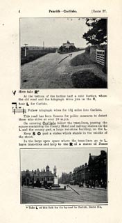 click to enlarge click to enlargeJS5004.jpg item:- private collection : 268.2 Image © see bottom of page |
|
|
|
||
| evidence:- | old map:- Burrow 1920s |
|
| source data:- | Road book, On the Road, Dunlop Pictorial Road Plans, volume V,
strip maps with parts in Westmorland, Cumberland etc, irregular
scale about 1.5 miles to 1 inch, by E J Burrow and Co,
Cheltenham, Gloucestershire, 1920s.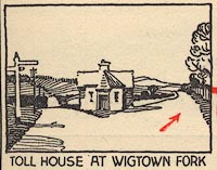 EJB3Vg22.jpg item:- private collection : 17 Image © see bottom of page |
|
|
|
||
 Lakes Guides menu.