 Old Cumbria Gazetteer
 |
 |
|
| St Bees Lighthouse, St Bees Head | ||
| St Bees Lighthouse | ||
| locality:- | North Head | |
| locality:- | St Bees Head | |
| civil parish:- | St Bees (formerly Cumberland) | |
| county:- | Cumbria | |
| locality type:- | lighthouse | |
| coordinates:- | NX94151437 | |
| 1Km square:- | NX9414 | |
| 10Km square:- | NX91 | |
|
|
||
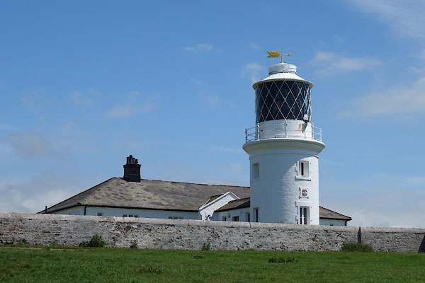 CDL32.jpg (taken 23.6.2015) 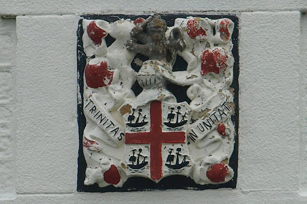 BPQ75.jpg Coat of arms of the Corporation of Trinity House, motto:- "TRINITAS IN UNITAM" (taken 29.8.2008) |
||
|
|
||
| evidence:- | old map:- OS County Series (Cmd 67 13) placename:- St Bees Lighthouse |
|
| source data:- | Maps, County Series maps of Great Britain, scales 6 and 25
inches to 1 mile, published by the Ordnance Survey, Southampton,
Hampshire, from about 1863 to 1948. |
|
|
|
||
| evidence:- | old text:- Gents Mag |
|
| source data:- | Magazine, The Gentleman's Magazine or Monthly Intelligencer or
Historical Chronicle, published by Edward Cave under the
pseudonym Sylvanus Urban, and by other publishers, London,
monthly from 1731 to 1922. goto source goto sourceGentleman's Magazine 1748 p.5 "..." "On the 30th we reached Bees-head, where is a light-house, but, in my opinion, the cradle is too much sunk within the battlements to afford a serviceable light to sailors; the point indeed is so prodigiously exposed, that a greater elevation would occasion a far greater consumption of fire; but coals are so plentiful in this neighbourhood, the expence ought not to be regarded, as 'tis the first land that sailors from the west endeavour to make. ..." |
|
|
|
||
| evidence:- | old drawing:- Smith 1746 B |
|
| source data:- | Drawing, pencil and ink, A View of Bees Head, in a Survey of the Coast of Cumberland,
by George Smith, 1746.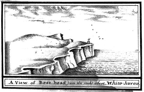 click to enlarge click to enlargeSM2102.jpg ms at bottom:- "A View of Bees-head, from the rocks above White-haven." item:- Carlisle Library : 5.2 Image © Carlisle Library |
|
|
|
||
| evidence:- | old map:- Donald 1774 (Cmd) |
|
| source data:- | Map, hand coloured engraving, 3x2 sheets, The County of Cumberland, scale about 1
inch to 1 mile, by Thomas Donald, engraved and published by Joseph Hodskinson, 29
Arundel Street, Strand, London, 1774.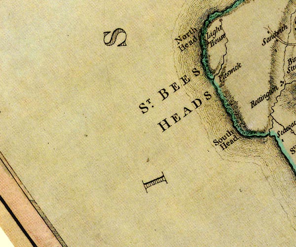 D4NX91SW.jpg "Light House" lighthouse tower item:- Carlisle Library : Map 2 Image © Carlisle Library |
|
|
|
||
| evidence:- | old map:- Otley 1818 |
|
| source data:- | Map, uncoloured engraving, The District of the Lakes,
Cumberland, Westmorland, and Lancashire, scale about 4 miles to
1 inch, by Jonathan Otley, 1818, engraved by J and G Menzies,
Edinburgh, Scotland, published by Jonathan Otley, Keswick,
Cumberland, et al, 1833.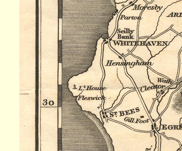 OT02NX91.jpg "Lt. House" Marked by a tower. item:- JandMN : 48.1 Image © see bottom of page |
|
|
|
||
| evidence:- | old text:- Gents Mag |
|
| source data:- | Magazine, The Gentleman's Magazine or Monthly Intelligencer or
Historical Chronicle, published by Edward Cave under the
pseudonym Sylvanus Urban, and by other publishers, London,
monthly from 1731 to 1922. goto source Gentleman's Magazine 1831 part 1 p.301 "[St Bees Head] ...On this height the new light-house, with nine reflectors, was erected in January 1822. ..." |
|
|
|
||
| evidence:- | old map:- Ford 1839 map |
|
| source data:- | Map, uncoloured engraving, Map of the Lake District of
Cumberland, Westmoreland and Lancashire, scale about 3.5 miles
to 1 inch, published by Charles Thurnam, Carlisle, and by R
Groombridge, 5 Paternoster Row, London, 3rd edn 1843.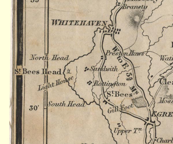 FD02NX91.jpg "Light House" Tower symbol, on St Bees Head. item:- JandMN : 100.1 Image © see bottom of page |
|
|
|
||
| evidence:- | old map:- Walker 1842 |
|
| source data:- | Chart, Position of all the Lighthouses in the British Isles,
scale about 38 nautical miles to 1 inch, published by J and A
Walker, 72 South Castle Street, Liverpool, Lancashire, 1842. marked as a coast light "St. Bees Hd. - Steady" |
|
|
|
||
| evidence:- | HO chart:- Hydrographic Office 1850s onwards (edn 1973) placename:- St Bees Head |
|
| source data:- | Charts, Irish Sea, Solway Firth, etc, published by the Hydrographic Office from 1850s
onwards. "St. Bees Head / Gp. Fl. (2) 20 sec. 336 ft. 21 M. / Fog Detr. Lt. E.F. Horn (2)" |
|
|
|
||
| evidence:- | old map:- Hydrographic Office 1850s onwards |
|
| source data:- | Chart, uncoloured engraving, England West Coast sheet XI,
Fleetwood to the Firth of Solway, scale about 2.5 miles to 1
inch, by H Denham and G Williams, 1846, engraved by J and C
Walker, published by the Hydrographic Office, 1850 corrected to
1863 coast view on Admiralty chart 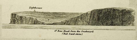 click to enlarge click to enlargeHY01P5.jpg "Lighthouse" item:- Carlisle Library : Map 93 Image © Carlisle Library |
|
|
|
||
| evidence:- | old text:- Admiralty 1933 |
|
| source data:- | goto source Page 384:- "... St. Bees Head light kept in sight leads westward of these dangers [Selker Rocks etc], in depths of not less than 10 fathoms (18m3) when abreast of Selker rocks, and vessels should not venture within the 10 fathom (18m3) line when abreast of the rocks." Page 385:- "..." "The whole coastline north-westward of Kokoarrah scar is clear of danger at one mile offshore, with depths of from 5 to 7 fathoms (9m1 to 12m8) at that distance." "St. Bees Head light kept in sight leads clear of all these dangers." goto sourcePage 389:- "... St. Bees head ..." "A light is exhibited, at an elevation of 336 feet (102m4), from a white circular tower, 55 feet (16m8) in height, situated near the edge of the cliff. A fog signal is sounded from the lighthouse." "St. Bees head, with its lighthouse, is easily recognised from a considerable distance. ..." |
|
| source data:- | Book, channel pilot, with photographs, including coast views, West Coast of England
Pilot, published for the Hydrographic Department of the Admiralty, by HMSO, 8th edn
1933.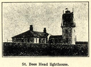 AY0102.jpg item:- JandMN : 1053 Image © see bottom of page |
|
|
|
||
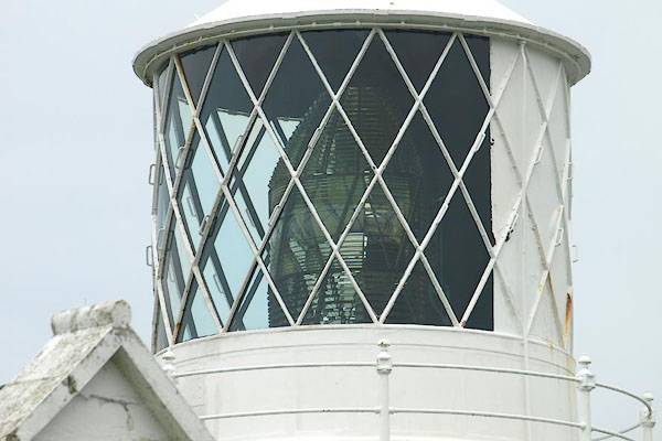 BPQ73.jpg Lantern, and the fresnel lens. (taken 29.8.2008) 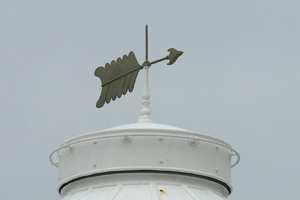 BPQ74.jpg Weathervane on the lantern. (taken 29.8.2008) 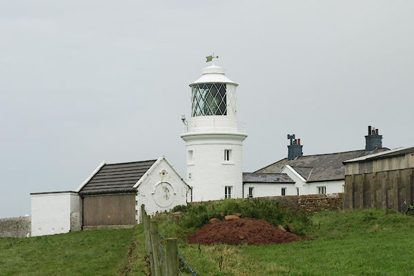 BPQ71.jpg (taken 29.8.2008) 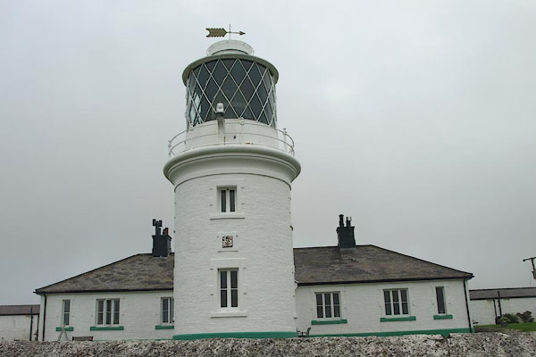 BPQ72.jpg (taken 29.8.2008) 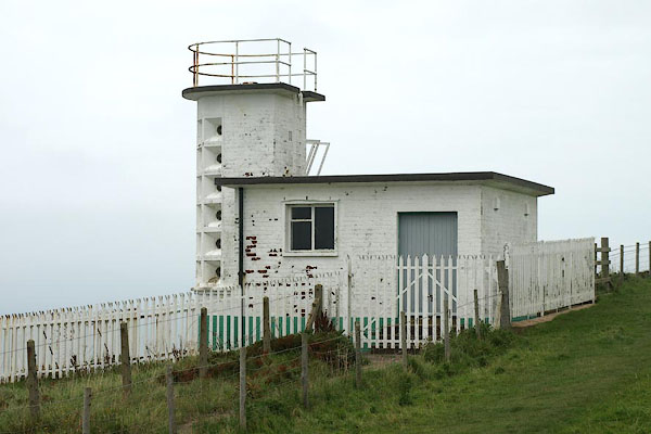 BPQ76.jpg Foghorn, a short way off on the cliff top, (taken 29.8.2008) |
||
|
|
||
| Woodman, Richard: 1985: View from the Sea: Century Publishing (London):: ISBN 0 7126
1024 3 |
||
|
|
||
| hearsay:- |
Trinity House were granted a patent for a light here in 1718, requested in response
to merchant traders sailing in these seas. They farmed out the task by a lease to
Thomas Lutwige for 99 years at an annual rent of L20.00. He was to build and maintain
a light, and was allowed to levy three halfpence per ton on shipping at Whitehaven,
Workington and Maryport for his trouble. He built an untidy tower with lighthouse
keepers' accomodation at the base. The keepers were paid 7s. a week; they climbed
up ladders to tend the fire in an iron basket hung from a gallows at the top. |
|
| William Hutchinson commented on the uselessness of coal lights in 1760s:- |
||
| "Open coal fire light, exposed to all winds and weathers, cannot be made to burn and
show a constant steady blaze to be seen at a sufficient distance ... for in storms
of wind, when lights are most wanted, these fires are made to burn furiously ... so
as to melt the very ironwork about the grate, and in cold weather when it snows, hails
or rains hard, the keepers of the lights do not care to expose themselves ..." |
||
| Robert Stevenson described the light in 1801:- |
||
| "St Bees light is from coals exposed upon the top of an old tower in an open chauffer,
which is at the top only two feet diameter, at bottom one foot six inches and two
feet deep; so that in storms, so small a body of fire cannot be kept up as it ought
ot be. About one hundred and thirty tons of coal are said to be used annually." |
||
| William Daniell RA, sketched the ruinous lighthouse in 1814, noting that it:- |
||
| "... was of the meanest description and provided with a very bad light supplied by
a coal fire. I imagine a light in this situation is admitted to be of very little
use or such a one as this could not scarcley be submitted to or escpae the vigilant
observation of the Trinity House." |
||
| It displayed the light of a coal fire, and its column of smoke in the daytime, till
1822 when the tower caught fire. There is said to be a painting of this early light
at Trinity House. |
||
| Joseph Nelson built a new tower at a cost of L2322.00, with argand burners and reflectors.
In the mid 19th century it was altered to a flashing light. New optics were fitted
in 1951; a 1500 watt electric lamp with a catadioptric lens, showing two white flashes
in twenty seconds. The light intensity is 146000 candelas and is visible 21miles on
a clear dark night. |
||
|
|
||
Lakes Guides menu.