 Old Cumbria Gazetteer
 |
 |
|
| Goat Crag, Borrowdale | ||
| Goat Crag | ||
| civil parish:- | Borrowdale (formerly Cumberland) | |
| county:- | Cumbria | |
| locality type:- | rocks | |
| coordinates:- | NY24461631 (etc) | |
| 1Km square:- | NY2416 | |
| 10Km square:- | NY21 | |
|
|
||
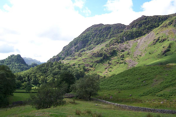 BUW17.jpg (taken 29.6.2011) |
||
|
|
||
| evidence:- | old map:- OS County Series (Cmd 70 5) placename:- Goat Crag |
|
| source data:- | Maps, County Series maps of Great Britain, scales 6 and 25
inches to 1 mile, published by the Ordnance Survey, Southampton,
Hampshire, from about 1863 to 1948. |
|
|
|
||
| evidence:- | outline view:- Otley 1823 (4th edn 1830) placename:- Gait Crag |
|
| source data:- | Print, engraving, outline view, Mountains South West of Derwentwater as seen from
Keswick, published by Jonathan Otley, Keswick, Cumberland et al, 1830.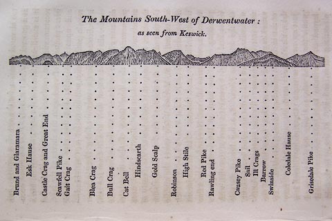 click to enlarge click to enlargeO75E06.jpg p.115 in A Concise Description of the English Lakes, by Jonathan Otley, 4th edition, 1830. "The Mountains South-West of Derwentwater: / as seen from Keswick." "Brund and Glaramara / Esk Hause / Castle Crag and Great End / Scawfell Pike / Gait Crag / Blea Crag / Bull Crag / Cat Bell / Hindscarth / Gold Scalp / Robinson / High Stile / Red Pike / Rawling end / Causey Pike / Sail / Ill Crags / Barrow / Swinside / Coledale Hause / Grisedale Pike" item:- Armitt Library : A1175.6 Image © see bottom of page |
|
|
|
||
| evidence:- | outline view:- Otley 1823 (8th edn 1849) placename:- Gate Crag |
|
| source data:- | Engraving, outline view of mountains, Derwent Water from Crow Park, drawn by T Binns,
engraved by O Jewitt, opposite p.10 of A Descriptive Guide of the English Lakes, by
Jonathan Otley, 8th edition, 1849.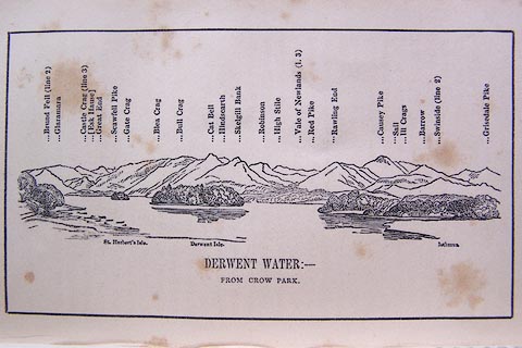 click to enlarge click to enlargeO80E06.jpg item:- Armitt Library : A1180.7 Image © see bottom of page |
|
|
|
||
| evidence:- | outline view:- Otley 1823 (5th edn 1834) placename:- Gait Crag |
|
| source data:- | Print, woodcut outline view, The Mountains South West of
Derwentwater, by Jonathan Otley, Keswick, Cumberland, 1830.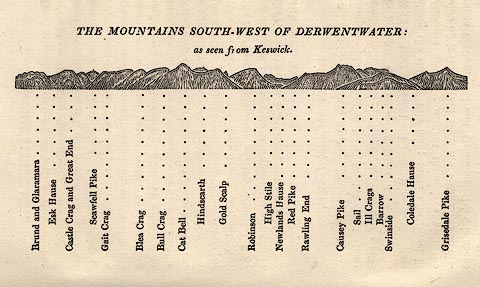 click to enlarge click to enlargeOT2E04.jpg Printed on p.21 of A Concise Description of the English Lakes, by Jonathan Otley, 5th edition, 1834. "THE MOUNTAINS SOUTH-WEST OF DERWENTWATER: as seen from Keswick" "Brund and Glaramara / Esk Hause / Castle Crag and Great End / Scawfell Pike / Gait Crag / Blea Crag / Bull Crag / Cat Bell / Hindscarth / Gold Scalp / Robinson / High Stile / Newlands Hause / Red Pike / Rawling End / Causey Pike / Sail / Ill Crags / Barrow / Swinside / Coledale Hause / Grisedale Pike" item:- JandMN : 48.5 Image © see bottom of page |
|
|
|
||
| evidence:- | old text:- Otley 1823 (5th edn 1834) placename:- Gait Crag |
|
| source data:- | Guide book, A Concise Description of the English Lakes, the
mountains in their vicinity, and the roads by which they may be
visited, with remarks on the mineralogy and geology of the
district, by Jonathan Otley, published by the author, Keswick,
Cumberland now Cumbria, by J Richardson, London, and by Arthur
Foster, Kirkby Lonsdale, Cumbria, 1823; published 1823-49,
latterly as the Descriptive Guide to the English Lakes. goto source goto sourcePage 80:- "THE CRAGS." "... Gait Crag (Goat Crag) in Borrowdale, ..." |
|
|
|
||
| evidence:- | perhaps old photograph:- Bell 1880s-1940s |
|
| source data:- | Photograph, black and white, Castle Crag, and Gates Crag perhaps Goat Crag, Borrowdale,
Cumberland, by Herbert Bell, Ambleside, Westmorland, 1890s.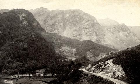 click to enlarge click to enlargeHB0381.jpg internegative at lower left:- "H. Bell" item:- Armitt Library : ALPS35 Image © see bottom of page |
|
|
|
||
| evidence:- | outline view:- Black 1856 (23rd edn 1900) placename:- Gatecrag |
|
| source data:- | Print, lithograph, Outline Views, Skiddaw and Derwent Water - Mountains as seen at
Lodore Hotel, and Mountains as seen at the Third Gate on Ascending Latrigg on the
Way to Skiddaw, by J Flintoft, Keswick, Cumberland, engraved by R Mason, Edinburgh,
Lothian, about 1900.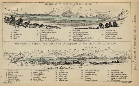 click to enlarge click to enlargeBC08E4.jpg "... Gatecrag ..." item:- JandMN : 37.14 Image © see bottom of page |
|
|
|
||
| evidence:- | outline view:- Black 1841 (3rd edn 1846) placename:- Gatecrag |
|
| source data:- | Print, engraving, outline view, Mountains as seen at Lowdore Inn, and Mountains as
seen at the Third Gate on Ascending Latrigg on the Way to Skiddaw, by J Flintoft,
Keswick, Cumberland, engraved by R Mason, Edinburgh, Lothian, about 1846.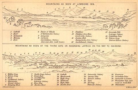 click to enlarge click to enlargeBC02E4.jpg "... Gatecrag ..." item:- JandMN : 32.7 Image © see bottom of page |
|
|
|
||
Lakes Guides menu.