 Old Cumbria Gazetteer
 |
 |
|
| viewpoint, Loweswater | ||
| locality:- | Loweswater | |
| civil parish:- | Loweswater (formerly Cumberland) | |
| county:- | Cumbria | |
| locality type:- | viewpoint | |
| coordinates:- | NY141211 (perhaps) | |
| 1Km square:- | NY1421 | |
| 10Km square:- | NY12 | |
|
|
||
| evidence:- | outline view:- Otley 1823 (4th edn 1830) |
|
| source data:- | Print, engraving, outline view, The Mountains of Crummock and Buttermere as seen on
the Road between Scale-Hill and Loweswater, published by Jonathan Otley, Keswick,
Cumberland et al, 1830.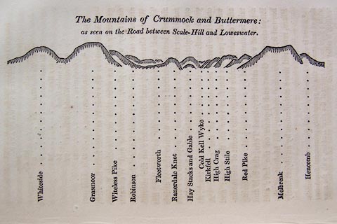 click to enlarge click to enlargeO75E07.jpg p.125 in A Concise Description of the English Lakes, by Jonathan Otley, 4th edition, 1830. printed at top:- "The Mountains of Crummock and Buttermere: / as seen on the Road between Scale-Hill and Loweswater." printed at bottom:- "Whiteside / Grasmoor / Witeless Pike / Robinson / Fleetworth / Rannerdale Knot / Hay Stacks and Gable / Cold Kell Wyke / Kirkfell / High Crag / High Stile / Red Pike / Melbreak / Hencomb" item:- Armitt Library : A1175.7 Image © see bottom of page |
|
|
|
||
| evidence:- | outline view:- Otley 1823 (5th edn 1834) |
|
| source data:- | Print, woodcut outline view, The Mountains of Crummock and Buttermere, by Jonathan
Otley, Keswick, Cumberland now Cumbria, 1834.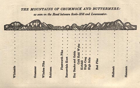 click to enlarge click to enlargeOT2E05.jpg Printed on p.25 of A Concise Description of the English Lakes, by Jonathan Otley, 5th edition, 1834. printed at top:- "THE MOUNTAINS OF CRUMMOCK AND BUTTERMERE: / as seen on the road between Scale-Hill and Loweswater." printed at bottom:- "Whiteside / Grasmoor / Witeless Pike / Robinson / Fleetworth Pike / Rannerdale Knot / Hay Stacks and Gable / Cold Keld Wyke / Kirkfell / High Crag / High Stile / Red Pike / Melbreak / Hencomb" item:- JandMN : 48.6 Image © see bottom of page |
|
|
|
||
| evidence:- | outline view:- Otley 1823 (8th edn 1849) |
|
| source data:- | Print, engraving, outline view of mountains, Crummock and Buttermere from the Road
near Loweswater Church, drawn by Mr Binns, Halifax, engraved by Mr Jewitt, Headington,
Oxfordshire, published by Jonathan Otley, Keswick, Cumberland et al, 1849.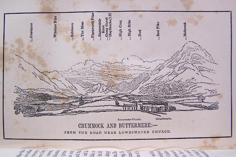 click to enlarge click to enlargeO80E10.jpg Opposite p.18 of A Descriptive Guide of the English Lakes, by Jonathan Otley, 8th edition, 1849. printed at bottom:- "CRUMMOCK AND BUTTERMERE: - / FROM THE ROAD NEAR LOWESWATER CHURCH." printed at top:- "Grasmoor / Witeless Pike / Robinson / The Moss / Fleetworth Pike / Rannerdale Knot / Great Gavel / Hay Stacks (l.2) / High Crag / High Stile / Dod / Red Pike / Melbreak" printed at bottom:- "Loweswater Church. Gilterthwaite." Looking SE; 80 degree view, EbyS to S. 'Gilterthwaite' is not where it is labelled, what is drawn is Church Stile. item:- Armitt Library : A1180.11 Image © see bottom of page |
|
|
|
||
 Lakes Guides menu.