 Old Cumbria Gazetteer
 |
 |
|
| viewpoint, Highfield | ||
| locality:- | Highfield | |
| civil parish:- | Windermere (formerly Westmorland) | |
| county:- | Cumbria | |
| locality type:- | viewpoint | |
| coordinates:- | SD405991 (roughly) | |
| 1Km square:- | SD4099 | |
| 10Km square:- | SD49 | |
|
|
||
| evidence:- | outline view:- Otley 1823 (4th edn 1830) |
|
| source data:- | Print, engraving, outline view, Mountains of Coniston, Langdale, &c. as they appear
from the road between Troutbeck Bridge and Bowness, published by Jonathan Otley, Keswick,
Cumberland et al, 1830.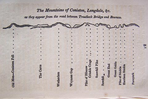 click to enlarge click to enlargeO75E04.jpg p.97 in A Concise Description of the English Lakes, by Jonathan Otley, 4th edition, 1830. printed at top:- "The Mountains of Coniston, Langdale, &c. / as they appear from the road between Troutbeck Bridge and Bowness." printed at bottom:- "Old Man - Coniston Fell / The Carrs / Wetherlam / Wrynose Gap / Pike of Bliscow / Crinkle Crags / Scawfell Pike / Bowfell / Great End / Great Gable / Pike of Stickle / Harrison Stickle / Paveyark" item:- Armitt Library : A1175.4 Image © see bottom of page |
|
|
|
||
| evidence:- | outline view:- Otley 1823 (5th edn 1834) |
|
| source data:- | Print, woodcut outline view, The Mountains of Coniston, Langdale, Etc, by Jonathan
Otley, Keswick, Cumberland now Cumbria, 1834.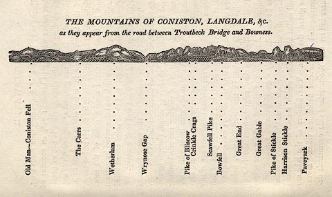 click to enlarge click to enlargeOT2E01.jpg Printed on p.7 of A Concise Description of the English Lakes, by Jonathan Otley, 5th edition, 1834. printed at top:- "THE MOUNTAINS OF CONISTON, LANGDALE, &c. / as they appear from the road between Troutbeck Bridge and Bowness." printed at bottom:- "Old Man - Coniston Fell / The Carrs / Wetherlam / Wrynose Gap / Pike of Bliscow / Crinkle Crags / Bowfell / Great End / Great Gable / Pike of Stickle / Harrison Stickle / Paveyark" item:- JandMN : 48.2 Image © see bottom of page |
|
|
|
||
| evidence:- | outline view:- Otley 1823 (8th edn 1849) |
|
| source data:- | Print, engraving, outline view of mountains, Windermere looking towards the West from
the Road between Troutbeck and Bowness, drawn by Mr Binns, Halifax, engraved by Mr
Jewitt, Headington, Oxfordshire, published by Jonathan Otley, Keswick, Cumberland
et al, 1849.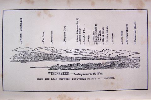 click to enlarge click to enlargeO80E03.jpg Opposite p.4 of A Descriptive Guide of the English Lakes, by Jonathan Otley, 8th edition, 1849. printed at bottom:- "WINDERMERE: - Looking towards the West. / FROM THE ROAD BETWEEN TROUTBECK AND BOWNESS." printed at top:- "Old Man - Coniston Fell / The Carrs / Wetherlam / (Wrynose Gap) / Pike of Bliscow (line 2) / Crinkle Crags / Scawfell Pike / Bowfell / Great End / Lingmoor (line 2) / Hindside / Great Gable / Pike of Stickle / Harrison Stickle / Paveyark / High Raise / Silverhow (line 2) / Hammerscar (line 2)" Looking WNW; 60 degree view, WbyS to NW. This is a 'viewpoint' on some OS maps. item:- Armitt Library : A1180.4 Image © see bottom of page |
|
|
|
||
 Lakes Guides menu.