 Old Cumbria Gazetteer
 |
 |
|
| toll house, Fawcett Forest | ||
| site name:- | road, Kendal to Shap | |
| civil parish:- | Fawcett Forest (formerly Westmorland) | |
| county:- | Cumbria | |
| locality type:- | toll gate (site) | |
| locality type:- | toll house (ex) | |
| locality type:- | buildings | |
| coordinates:- | NY54640126 | |
| 1Km square:- | NY5401 | |
| 10Km square:- | NY50 | |
|
|
||
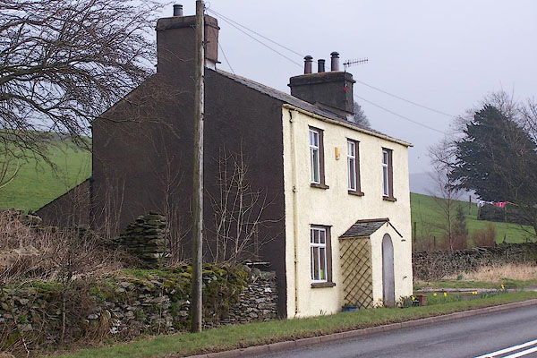 BNL64.jpg (taken 30.3.2007) |
||
|
|
||
| evidence:- | old map:- OS County Series |
|
| source data:- | Maps, County Series maps of Great Britain, scales 6 and 25
inches to 1 mile, published by the Ordnance Survey, Southampton,
Hampshire, from about 1863 to 1948. "T.P." |
|
|
|
||
| evidence:- | road book:- Cary 1798 (2nd edn 1802) placename:- Huck |
|
| source data:- | Road book, itineraries, Cary's New Itinerary, by John Cary, 181
Strand, London, 2nd edn 1802. goto source goto source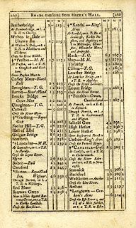 click to enlarge click to enlargeC38267.jpg page 267-268 "Huck - T.G." toll gate; 6m 2f from Kendal item:- JandMN : 228.1 Image © see bottom of page |
|
|
|
||
| evidence:- | old directory:- Parson and White 1829 placename:- Bannisdale Gate |
|
| source data:- | Book, History, Directory, and Gazetteer, of the Counties of
Cumberland and Westmorland, with that Part of the Lake District
in Lancashire, forming the Lordships of Furness and Cartmel, by
William Parson and William White, published by W White and Co,
44 Hunslet Lane, Leeds, Yorkshire, 1829. Lists Matthew Laycock, toll collector |
|
|
|
||
Lakes Guides menu.