 Old Cumbria Gazetteer
 |
 |
|
| milestone, Dearham | ||
| site name:- | road, Cockermouth to Maryport | |
| civil parish:- | Dearham (formerly Cumberland) | |
| county:- | Cumbria | |
| locality type:- | milestone | |
| coordinates:- | NY06653524 | |
| 1Km square:- | NY0635 | |
| 10Km square:- | NY03 | |
|
|
||
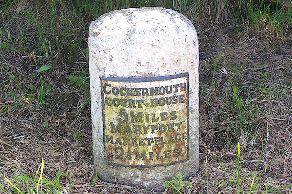 BNR94.jpg Cast iron on stone:- "COCKERMOUTH C/ COURT-HOUSE / 5 MILES / MARYPORT / MARKET-PLACE / 2¼MILES" (taken 25.5.2007) |
||
|
|
||
| evidence:- | old map:- OS County Series (Cmd 45 10) |
|
| source data:- | Maps, County Series maps of Great Britain, scales 6 and 25
inches to 1 mile, published by the Ordnance Survey, Southampton,
Hampshire, from about 1863 to 1948. "MS. Cockermout .. 5 Maryport .. 2 1/4" |
|
|
|
||
| evidence:- | database:- Listed Buildings 2010 |
|
| source data:- | courtesy of English Heritage "MILESTONE AT ABOVE MAP REF / / / DEARHAM / ALLERDALE / CUMBRIA / II / 72230 / NY0665135243" |
|
| source data:- | courtesy of English Heritage "Milestone. Late C18 or early C19. Whitewashed red sandstone. Round-topped stone with cast iron plate to front inscribed COCKERMOUTH COURT-HOUSE 5 MILES, MARYPORT MARKET-PLACE 21/4 MILES. Lettering picked out in black. OS bench mark on top of stone." |
|
|
|
||
 Lakes Guides menu.