 Old Cumbria Gazetteer
 |
 |
|
| milestone, Bridekirk | ||
| site name:- | road, Cockermouth to Carlisle | |
| civil parish:- | Bridekirk (formerly Cumberland) (?) | |
| county:- | Cumbria | |
| locality type:- | milestone | |
| coordinates:- | NY11913226 | |
| 1Km square:- | NY1132 | |
| 10Km square:- | NY13 | |
|
|
||
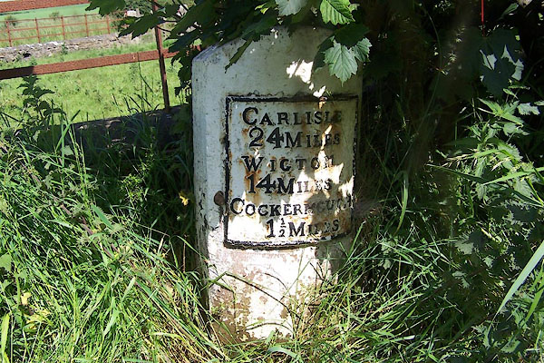 BNV44.jpg Cast iron plate on stone:- "CARLISLE / 24 MILES / WIGTON / 14 MILES / COCKERMOUTH / 1½MILES" (taken 20.6.2007) |
||
|
|
||
| evidence:- | old map:- OS County Series (Cmd 45 16) placename:- |
|
| source data:- | Maps, County Series maps of Great Britain, scales 6 and 25
inches to 1 mile, published by the Ordnance Survey, Southampton,
Hampshire, from about 1863 to 1948. "M.S. Carlisle .. 24 Wigton .. 14 Cockermouth .. 1/2" |
|
|
|
||
| evidence:- | database:- Listed Buildings 2010 |
|
| source data:- | courtesy of English Heritage "MILESTONE SOUTH OF ANN'S HILL / / / BRIDEKIRK / ALLERDALE / CUMBRIA / II / 72577 / NY1191032271" |
|
| source data:- | courtesy of English Heritage "Milestone. Late C18 or early C19. Whitewashed stone with rounded top. Cast iron plate fixed to curved face inscribed CARLISLE 24 MILES, WIGTON 14 MILES, COCKERMOUTH 1 1/2 MILES." |
|
|
|
||
 Lakes Guides menu.