 Old Cumbria Gazetteer
 |
 |
|
| Debatable Land, Kirkandrews | ||
| Debatable Land | ||
| Debateable Land | ||
| Threpelands | ||
| Threaplands | ||
| civil parish:- | Kirkandrews (formerly Cumberland) | |
| county:- | Cumbria (Cumberland) | |
| locality type:- | area | |
| 10Km square:- | NY37 | |
| 1Km square:- | NY3070 | |
| 10Km square:- | NY37 | |
|
|
||
| evidence:- | old map:- |
|
| source data:- | Reproduction map, black and white halftone, the Debateable Land,
Cumberland and Scotland, with lines of proposed divisions, by
Henry Bullock, 1552; published by Cumberland and Westmorland
Antiquarian and Archaeological Society, Kendal, Westmorland,
1914.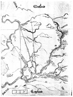 click to enlarge click to enlargeM068.jpg Reproduction map, black and white halftone, the Debatable Land, Cumberland and Scotland, with lines of proposed divisions, 1552; published by Cumberland and Westmorland Antiquarian and Archaeological Society, Kendal, Westmorland, 1914. Reproduced with an article about the Debatable Land by T H B Graham. printed at alongside a proposed partition:- "[The English commiss. offer]" printed at alongside a proposed partition:- "[The accord wt ye ff. ambassador, linea stellata]" printed at alongside a proposed partition:- "[The Scottes offerr]" printed at alongside a proposed partition:- "[This is the last and fynal lyne of the parcon concluded xxiiij Septembris 1552]" item:- private collection : 230 Image © see bottom of page |
|
|
|
||
| evidence:- | old map:- Burghley 1590 (facsimile) placename:- Debatable Lande |
|
| source data:- | Facsimile map, A Platt of the Opposete Border of Scotland to ye West Marches of England,
parts of Cumberland and Scotland including the Debateable Land, from a manuscript
drawn for William Cecil, Lord Burghley, about 1590, published by R B Armstrong, 1897. courtesy of the National Library of Scotland 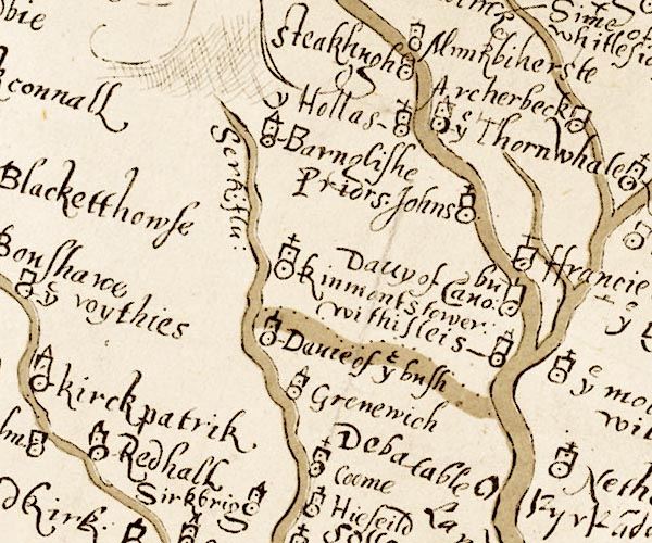 M048NY37.jpg "Debatable Lande" 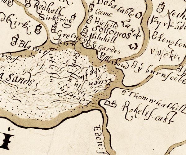 M048NY36.jpg item:- National Library of Scotland : MS6113 f.267 Images © National Library of Scotland |
|
|
|
||
| evidence:- | old map:- |
|
| source data:- | Reproduction map, black and white halftone, Platt of the Forrest
of Nicholl and the Mannor of Liddale, including the Debateable
Land, Cumberland and Scotland, 1607; published by Cumberland and
Westmorland Antiquarian and Archaeological Society, Kendal,
Westmorland, 1914.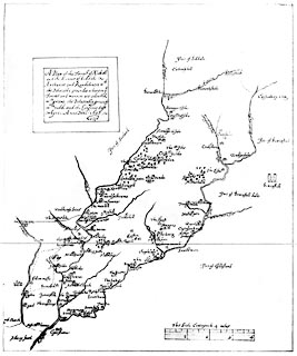 click to enlarge click to enlargeM067.jpg Reproduction map, black and white halftone, Platt of the Forrest of Nicholl and the Mannor of Liddale, including the Debatable Land, Cumberland and Scotland, 1607; published by Cumberland and Westmorland Antiquarian and Archaeological Society, Kendal, Westmorland, 1914. Reproduced with an article about the Debatable Land by T H B Graham. printed at plain cartouche, upper left:- "A Platt of the Forrest of Nicholl / and the Manor of Liddale / Arthurett and Randelinton wth. / the Debatable grounds: wherein ye / Forrest and mannors are coloured / wth. greene.the Debateable grounds / wth. redd, and the Confines left / whyte. Anno Doni: 1607" printed at with the scale line:- "This Scale Conteyneth 4 miles" item:- private collection : 229 Image © see bottom of page |
|
|
|
||
| evidence:- | descriptive text:- Simpson 1746 placename:- Batable Ground item:- Act of Union 1707 |
|
| source data:- | Atlas, three volumes of maps and descriptive text published as
'The Agreeable Historian, or the Compleat English Traveller
...', by Samuel Simpson, 1746. goto source goto source"... The Country beyond this Place [Solway Moss] was, before the Union of the two Kingdoms, called Batable-Ground, i.e. Lands always in Debate, the Inhabitants on both Sides always contending for it, and yielding it to neither; but now all those Feuds and Quarrels upon the Borders are ceased, and both Nations dwell in it with as much Safety and Security as in any other Place." |
|
|
|
||
| evidence:- | old map:- Donald 1774 (Cmd) |
|
| source data:- | Map, hand coloured engraving, 3x2 sheets, The County of Cumberland, scale about 1
inch to 1 mile, by Thomas Donald, engraved and published by Joseph Hodskinson, 29
Arundel Street, Strand, London, 1774.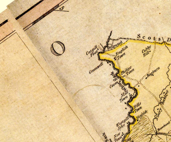 D4NY37SW.jpg "Disputed" disputed area between Scotland and Cumberland item:- Carlisle Library : Map 2 Image © Carlisle Library |
|
|
|
||
| evidence:- | old text:- Clarke 1787 placename:- Debateable Ground item:- dun cow |
|
| source data:- | Guide book, A Survey of the Lakes of Cumberland, Westmorland,
and Lancashire, written and published by James Clarke, Penrith,
Cumberland, and in London etc, 1787; published 1787-93. goto source Page x:- "..." "There still remains to mention another trifle, which was a nursery to the disorders, and an inexhaustible source of contention: this was the debateable ground; of which I shall relate nothing but what the order for its settlement in the days of Edward VI. authorises. Its length could not exceed 5 miles, extending from Esk to Sark at Dimmisdale Syke-foot, and thence to Kirk-ling: yet this was only the boundary of the kingdoms then made; for the real boundary was never known before, with certainty, in this piece of ground, on account of the immemorial disorders which had prevailed there, and even the antiquity of its being debateable was too remote for the longest-lived tradition. It is said that this trifling piece of ground, from the most trifling circumstances, and given birth to prodigious, and, if we respect the causes, astonishing commotions between the two kingdoms; being the sink and receptacle of proscribed wretches, who acknowledged neither King, obeyed the laws of neither country, and feared no punishment: that hence they grew to such a pitch of boldness, as to live en-" goto sourcePage xi:- "[en]tirely on spoils, to plunder each side, and, having allured partners to share their irregularities, to do all manner of mischief. To finish therefore this evil, the foregoing boundary was drawn by the consent of both, and pyramids of hewn stone erected, that the laws of each country might more precisely and effectually reach these villains: however, their old habits were not thus eradicated, even after the kingdoms had both one King, (though one may reasonably conjecture that this disposition would then gradually have fallen away of itself,) till James I. whether or no to facilitate the journeys of his dun-cow is not recorded, made some sort of a transportation or dispersion of this set of inhabitants, and since that time the mischief has ceased." "..." goto sourcePage 9:- "..." "... Even among the inhabitants of the debateable ground there was a kind of principle of honour mixed with their thefts; for, though outlaws from both kingdoms, and punished with death when taken, they seldom or never did violence to the person of the traveller, and have even been known to do actions of the highest generosity to those whose misfortunes needed such assistance. This is, as far as I can determine, the real character of the northern counties:" "..." goto sourcePage 174:- "..." "At last this debatable land, (which was the cause of all these murders and quarrels,) was settled by Commissioners, (viz.) the Lord Wharton and Sir Thomas Challoner on the part of England, and Sir James Douglas and Sir Richard Maitland for Scotland. They divided it, (where no stream was) by a sod hedge, now called the Scots Dyke; the western part was given to England, and is now the estate of Sir James Graham, Baronet, of Netherby, ..." "After this accomodation and division, there were, however, little peace among the borderers, till the union in 1706, depredations on all sides being still continued. ..." |
|
|
|
||
| evidence:- | old text:- Camden 1789 placename:- Batable Ground |
|
| source data:- | Book, Britannia, or A Chorographical Description of the Flourishing Kingdoms of England,
Scotland, and Ireland, by William Camden, 1586, translated from the 1607 Latin edition
by Richard Gough, published London, 1789. goto source Page 175:- "..." "... The Esk comes from Scotland, but for some miles owns itself a subject of England, and receives the river Kirsop, where the English and Scots lately separated not so much by the river as their mutual fears gave ample proof of the great qualities of both nations. ..." goto sourcePage 176:- "..." "... The country hereabouts [Solway Moss] is called Batable ground, because in debate between the English and Scots. The people on both sides, like borderers, are an active, crafty, and light sort of soldiery, and expert in skirmishing. ..." |
|
|
|
||
| evidence:- | old text:- Camden 1789 (Gough Additions) placename:- Batable Ground item:- boundary England/Scotland; national boundary |
|
| source data:- | Book, Britannia, or A Chorographical Description of the Flourishing Kingdoms of England,
Scotland, and Ireland, by William Camden, 1586, translated from the 1607 Latin edition
by Richard Gough, published London, 1789. goto source Page 195:- "..." ""... On the one side of it [Esk] is the batable ground, so that it is a limes Angliae &Scotiae. ..."" |
|
|
|
||
| evidence:- | old text:- Camden 1789 (Gough Additions) placename:- Debatable Ground |
|
| source data:- | Book, Britannia, or A Chorographical Description of the Flourishing Kingdoms of England,
Scotland, and Ireland, by William Camden, 1586, translated from the 1607 Latin edition
by Richard Gough, published London, 1789. goto source Page 199:- "The Debateable ground was a tract of land claimed by both kingdoms, which was the occasion of infinite troubles and vexations. The boundary of it in an old roll is thus described: "Beginning at the foot of the White Scyrke running into the sea, and so up the said water of Scyrke till it come to a place called Pyngilburne foot running into the said water of Scyrke and up the Pyngilburne till it come to Pyngilburne Know, from thence to the Righeads, from the Righeads to the Monke Rilande Burne, and from thence down to Har-" goto sourcePage 200:- ""[Har]venburne till it fall in Eske and through Eske to the foot of Terras, and go up Terras to the foot of Reygill and up the Reygill to the Tophous and so to the standing stone and to the Mearburne head, and down Mearburne to it fall in Lyddal at the Rutterford, and down Lyddal to it fall in Eske and down Eske to it fall into the sea." It was in length eight computed miles of the country and in breadth four miles. The subjects of both kingdoms commonly depastured their cattle on it in the day time, but were to remove them before the sunset, on the peril that should ensue." |
|
|
|
||
| evidence:- | old text:- Gents Mag item:- Border Wars; borderers; map; Border Topography of Scotland; Platt or Map of the Borders |
|
| source data:- | Magazine, The Gentleman's Magazine or Monthly Intelligencer or
Historical Chronicle, published by Edward Cave under the
pseudonym Sylvanus Urban, and by other publishers, London,
monthly from 1731 to 1922. goto source Gentleman's Magazine 1828 part 2 p.420 Review of an article in Archaeologia vol.22 part 1:- "XII. copy of a Manuscript Tract, addressed to Lord Burghley, illustrative of the Border Topography of Scotland, A.D. 1590; with a Platt or Map of the Borders, taken in the same year." "Communicated by Henry Ellis, esq." "The military spirit of the Borderers was kept up, it seems, by mutual fears of incursion; and 'diamond cut diamond.' - A curious elucidation of surnames, taken from clans, and in England, occurs in this documentand it shows that families, like hares and rabbits, kept together in the same district." "'Eske. - Upon both sides of the river dwell the Grames, which is the greatest surname at this day upon the West Border. For the Grames of Eske and Leven are able to make vC. serviceable men. There dwelleth also a surname of Stories, but they are sore decayed.'" "'Leven. - Upon this river also dwelleth many Grames, and above Kirklynton on Sompert dwelleth a great surname of Fosters, and about Hethersgill is a surname of Hetheringtons.' P.169." "The private life and demoralized habits of these Borderers we have recently exhibited and explained in our Review of Mr. Hodgson's Redesdale. (See p.53)" |
|
|
|
||
| evidence:- | old map:- Bullock 1552 (version 1913) |
|
| source data:- | Copy map, uncoloured lithograph, Debateable Land, Platt made by
Henry Bullock 1552, copied by John F Curwen, 1912, scale about
1.5 miles to 1 inch, published for the Cumberland and
Westmorland Antiquarian and Archaeological Society by Titus
Wilson, Kendal, Westmorland, 1913.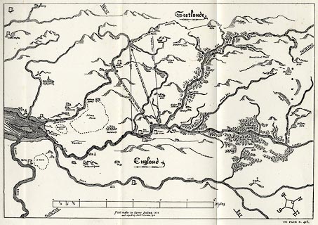 click to enlarge click to enlargeCW01M3.jpg Copy map, uncoloured lithograph, Debatable Land, Platt made by Henry Bullock 1552, copied by John F Curwen, 1912, scale about 1.5 miles to 1 inch, published for the Cumberland and Westmorland Antiquarian and Archaeological Society by Titus Wilson, Kendal, Westmorland, 1913. In copying the placename labels have been transcribed to be more readable. Tipped in opposite p.416 of The Castles and Fortified Towers of Cumberland, Westmorland, and Lancashire North of the Sands, by John F Curwen. printed at lower centre:- "Platt made by Henry Bullock, 1552 / and copied by John F Curwen, 1912." item:- Armitt Library : A782.88 Image © see bottom of page |
|
|
|
||
| Armstrong, Robert Bruce: 1883: History of Liddesdale Eskdale ewesdale Wauchopedale
and the Debateable Land: Douglas, David (Edinburgh) Borland, Robert: 1898: Border Raids and Reivers: Fraser, Thomas (Dalbeattie) Camden, William &Gough, Richard (ed): 1789: Britannia: (London) Clarke, James: 1787: Survey of the Lakes of Cumberland, Westmorland and Lancashire: (Penrith, Cumberland, and London) Fraser, George MacDonald: 1971 &1986 (reprint): Steel Bonnets, The: Collins Harvill (London):: ISBN 0 00 217261 5 Graham, T H B: 1912: Debateable Land, The (part 1): Trans CWAAS: 2nd series vol.12: pp.33-58 and 2 plates Graham, T H B: 1914: Debateable Land, The (part 2): Trans CWAAS: 2nd series vol.14: pp.132-157 and plates |
||
|
|
||
| also see:- | Border Marches |
|
|
|
||
Lakes Guides menu.