 Old Cumbria Gazetteer
 |
 |
|
| milestone, Embleton (3) | ||
| site name:- | road, Keswick to Cockermouth | |
| civil parish:- | Embleton (formerly Cumberland) | |
| county:- | Cumbria | |
| locality type:- | milestone | |
| coordinates:- | NY18293074 | |
| 1Km square:- | NY1830 | |
| 10Km square:- | NY13 | |
|
|
||
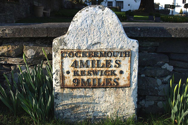 BOQ76.jpg Cast iron plate on stone:- "COCKERMOUTH / 4 MILES / KESWICK / 9 MILES" (taken 13.2.2008) |
||
|
|
||
| evidence:- | old map:- OS County Series (Cmd 55 3) |
|
| source data:- | Maps, County Series maps of Great Britain, scales 6 and 25
inches to 1 mile, published by the Ordnance Survey, Southampton,
Hampshire, from about 1863 to 1948. "M.S. COCKERMOUTH .. 4 KESWICK .. 9" "" |
|
|
|
||
| evidence:- | database:- Listed Buildings 2010 |
|
| source data:- | courtesy of English Heritage "MILESTONE OUTSIDE OF CLOSE FARMHOUSE / / / EMBLETON / ALLERDALE / CUMBRIA / II / 72661 / NY1828830747" |
|
| source data:- | courtesy of English Heritage "Milestone. Early C19 for the Cockermouth-Keswick Turnpike. Whitewashed slate with shaped top and front cast iron plate inscribed COCKERMOUTH 4 MILES, KESWICK 9 MILES; lettering picked out in black." |
|
|
|
||
 Lakes Guides menu.