 Old Cumbria Gazetteer
 |
 |
|
| Scar, Buttermere | ||
| civil parish:- | Buttermere (formerly Cumberland) | |
| civil parish:- | Above Derwent (formerly Cumberland) | |
| county:- | Cumbria | |
| locality type:- | rocks | |
| locality type:- | boundary feature | |
| locality type:- | parish boundary feature | |
| coordinates:- | NY19562026 | |
| 1Km square:- | NY1920 | |
| 10Km square:- | NY12 | |
|
|
||
| evidence:- | old map:- OS County Series (Cmd 63 15) placename:- Scar, The |
|
| source data:- | Maps, County Series maps of Great Britain, scales 6 and 25
inches to 1 mile, published by the Ordnance Survey, Southampton,
Hampshire, from about 1863 to 1948. |
|
|
|
||
| evidence:- | outline view:- Barrow 1888 placename:- Scar |
|
| source data:- | Outline view, engraving? Outline of Mountain Tops as seen from the Keswick Hotel,
sketched by John Barrow, published by Sampson Low, Marston, Searle, and Rivington,
St Dunstan's House, Fetter Lane, Fleet Street, London, 1888.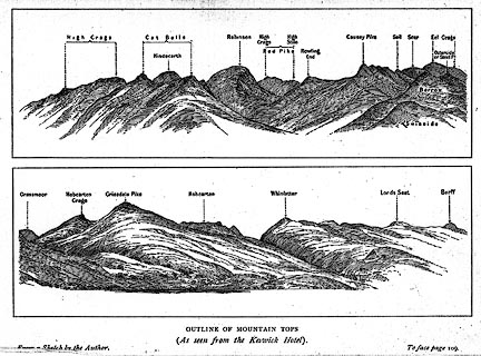 click to enlarge click to enlargeBRW1.jpg "... Scar ..." item:- Kendal Library : 10.3 Image © see bottom of page |
|
|
|
||
 Lakes Guides menu.