 Old Cumbria Gazetteer
 |
 |
|
| Barrow Docks, Barrow-in-Furness | ||
| Barrow Docks | ||
| Port of Barrow | ||
| locality:- | Barrow-in-Furness | |
| civil parish:- | Barrow-in-Furness (formerly Lancashire) | |
| county:- | Cumbria | |
| locality type:- | harbour | |
| locality type:- | dock | |
| coordinates:- | SD20016864 (etc) | |
| 1Km square:- | SD2068 | |
| 10Km square:- | SD26 | |
|
|
||
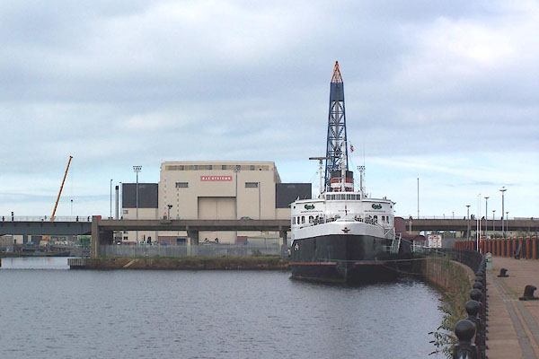 BOG48.jpg (taken 10.10.2007) 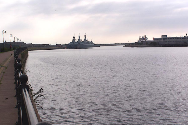 BOG49.jpg (taken 10.10.2007) |
||
|
|
||
| evidence:- | old map:- Garnett 1850s-60s H |
|
| source data:- | Map of the English Lakes, in Cumberland, Westmorland and
Lancashire, scale about 3.5 miles to 1 inch, published by John
Garnett, Windermere, Westmorland, 1850s-60s.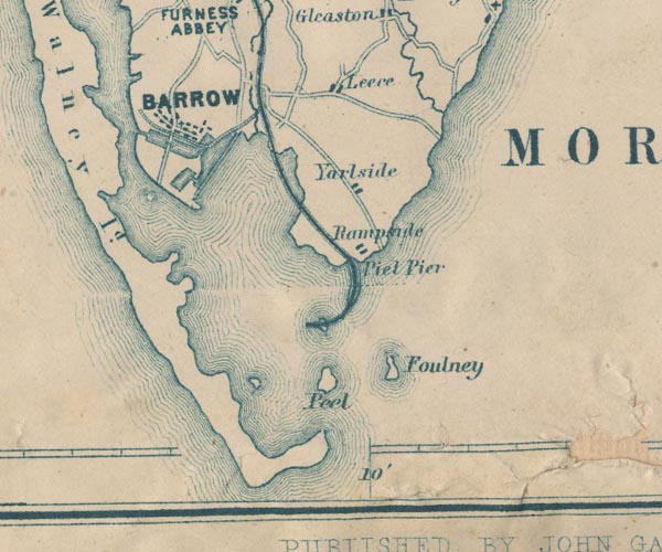 GAR2SD26.jpg drawn in outline item:- JandMN : 82.1 Image © see bottom of page |
|
|
|
||
| evidence:- | old text:- Admiralty 1933 item:- pilot, Barrow Docks; Barrow pilot |
|
| source data:- |  goto source goto sourcePage 364:- "[Pilotage.] ..." "The Barrow pilot-vessel is a ketch-rigged, steam vessel with the word "Pilot" painted in white letters on the sides. This vessel does not cruise regularly, but, when vessels are due, it will cruise between Lightning Knoll light-and-bell-buoy and Morecambe Bay light-vessel from 3 hours before until one hour after high water, unless prevented by stress of weather or other unavoidable cause. Vessels requiring a pilot should make the usual signals; the signal to be made by a vessel requiring a pilot in foggy weather is four long blasts; there is no special reply to this signal. They should await the pilot at about one mile south-westward of Lightning Knoll light-and-bell-buoy; those arriving off the port after high water should anchor and be under way again 2 hours before high water." "The Trinity House pilots for Barrow mostly reside on Roa island; telegraphic messages should be addressed to "Pilot station, Barrow."" "Fleetwood pilots may conduct vessels to Piel (Lat. 54~ 04' N., Long. 3~ 10' W.)" "Signals. - The signal to be made by vessel requiring a tug, for Barrow-in-Furness docks, by day, is:- Any pennant displayed at the fore, and/or four long blasts on the siren or steam whistle; or" "At night:- four long blasts on the siren or steam whistle." "..." |
|
|
|
||
| evidence:- | old text:- Admiralty 1933 placename:- Barrow-in-Furness Docks item:- ironworks, Hindpool; navigation lights; semaphore; dredger; buoys; tidal stream; cranes; submarine cable; railways; storm signal |
|
| source data:- | goto source Page 375:- "..." "APPROACH TO BARROW-IN-FURNESS DOCKS. - Aspect. - Walney island, within which is Piel harbour and the port of Barrow, is low throughout, the highest part, which is only 64 feet (19m5) high, being near the church abreast of Barrow, about 4 1/4 miles from the southern end of the island. The lighthouse, situated near the south-eastern extremity of the island, the look-out house, flagstaff and semaphore near Hilpsford point, at the south-western extremity of the island, the church remarked on above, and a mill, situated near the northern end of the island (chart 1826), are all conspicuous objects." "..." "The ruined castle on Piel island (Lat. 54~ 04' N., Long. 3~ 10' W.), about 8 cables northward of Walney Island lighthouse, Yarlside church tower, about 2 miles farther northward, and the Town hall at Barrow-in Furness are also conspicuous." goto sourcePage 376:- "Caution. - The navigational lights in this neighbourhood are not always easy to distinguish, on account of the glare which sometimes emanates from the iron-works along this coast; the glare from the iron-works at Hindpool. the northern part of Barrow, has occasionally been seen from distances more than 15 miles westward of Walney island." "Pilotage. - See page 363" "Tugs. - Two tugs are available; for signals see page 364." "Entrance channel. - Depths. - Sandflats, with depths of less than 3 fathoms (5m5) over them, extend about 2 1/2 miles south-south-westward from Hilpsford point, the south-western point of Walney island and northern point of the entrance to Morecambe bay." "Lightning knoll, with a least depth of 9 feet (2m7) over it, lies at the outer end of the above-mentioned sandflats." "The outer part of the entrance channel to Piel harbour and Barrow-in-Furness docks lies between these flats and Mort flat, with depths of less than 2 fathoms (3m7) over it, which occupies the north-western portion of Morecambe bay; Dione boulder, with depths of less than 6 feet (1m8) over it, and Outer boulders, awash, lie near the north-western edge of Mort flat." "The channel up to and through the bar, 7 cables south-south-westward of the south-eastern point of Walney island, has been dredged to a general depth of 11 feet (3m4) on the leading line, and to a least depth of 9 feet (2m7) for a width of 200 feet (61m0); it is very narrow throughout, and has depths of 6 feet (1m8) and less near the edge in places on either side." "The entrance to the harbour, within the above-mentioned shoals, is between Walney island and Seldom Seen, a bank of boulders which dry 4 feet (1m2), situated about 2 cables eastward of the south-eastern extremity of the island. Farhill scar, which dries 8 feet (2m4) in places, lies northward of Seldom Seen, it is connected to Foulney Island flats, which are connected to the flats that extend off Roa island and form the northern and eastern sides of Piel harbour." "Roa island is connected to the mainland northward of it by a railway embankment. A rubble causeway, which is awash at high water springs, connects Foulney island to this embankment. The village of Piel, in which the pilots reside, stands on this island. A wooden boat slip extends southward from the island." "Haws point, at the eastern end of Walney island, which forms the western side of the entrance, is fronted by a steep shingle beach; farther northward, on the western side of the channel, Piel scar dries out about 3 1/2 cables from the southern tip of Piel island (Lat. 54~ 04' N., Long. 3~ 10' W.), and Coup scar nearly 3 cables from its northern side." "There is a landing pier on the eastern side of Piel island." "Piel harbour lies between Piel island and the mainland north-eastward of it. It has depths from 3 to 5 fathoms (5m5 to 9m1), and is the easiest of entry of all the harbours in Morecambe bay, but it is not available for large vessels, except as a temporary anchorage." "Farther north-westward, the channel, which continues to be very narrow, passes between the drying banks which extend north-eastward from the north-eastern side of Walney island, and those which extend south-westward from the mainland." goto sourcePage 377:- "A least depth of 3 3/4 feet (1m1) is maintained by dredging in a channel, 400 feet (121m9) wide, between Piel harbour and the docks." "Winds. - Caution. - South-westerly and westerly winds, which cause considerable sea in the entrance channel, are the most dangerous winds." "Strong south-westerly and westerly gales increase the depths in Walney channel; easterly winds have the opposite effect." "Dredging. - Signals. - Dredging is generally in progress in the channel between Piel harbour and the docks." "A black ball is displayed, by day, on the side of the dredger which is clear for vessels to pass; at night, three white lights are exhibited in the form of a triangle, and a fourth white light 6 feet (1m8) below one angle of the triangle, on the side which is clear for vessels to pass." "The ordinary fog signal for a vessel not under way is sounded when required." "Vessels should pass the dredger at a moderate speed." "Lights. - Beacons. - A light is exhibited, at an elevation of 70 feet (21m3), from a stone tower, 60 feet (18m3) in height, situated about 1 3/4 cables north-westward of South East point, Walney island." "A light is exhibited, at an elevation of 26 feet (7m9), from an iron pile structure, 40 feet (12m2) in height, situated on the ledge off Haws point and about 3 cables east-north-eastward of Walney lighthouse." "The channel through Piel bar, and up to the pile lighthouses described below, is indicated by three sets of leading lights. The first set, numbered 1 and 2, is situated on the southern and south-eastern sides of Foulney island; the second set, numbered 3 and 4, is situated on Rampside sands, which lie northward of Foulney island, between it and the mainland near Rampside, nearly one mile north-north-eastward of Roa island; and the third set, numbered 5 and 6, on Biggar sands (Lat. 54~ 06' N., Long. 3~ 14' W.), the south-western side of Barrow channel, south-westward of Ramsden dock entrance." "The front light of each set bears an odd number, and is exhibited, at an elevation of 20 feet (6m1), from the summit of a pile structure diagonally boarded and painted black; the rear lights are exhibited, at different heights, from the summits of square red brick columns, the faces of which are of white bricks (see sketches on chart 3164). The first rear light is exhibited at an elevation of 38 feet (11m6), the second at 46 feet (14m0), and the third at 61 feet (18m6). The line of bearing of Nos.1 and 2, is 041~; of Nos.3 and 4, 006; and of Nos.5 and 6, 298~." "The limits of the channel for the outer reach are indicated by two sets of beacons, those northward and north-eastward, respectively, of No.1 light being painted black with square topmarks, and those westward and southward of No.2 light, white with red disk topmarks." "There are also a number of beacons, for the guidance of dredgers only, which are liable to be moved at any time." "A light is exhibited, at an elevation of 26 feet (7m9), from East pile, 55 feet (16m8) in height, which is situated on the northern side of the channel about 1 1/2 miles west-north-westward of Roa island." "A light is exhibited, at an elevation of 26 feet (7m9), from West" goto sourcePage 378:- "pile, 48 feet (14m6) in height, situated on the north-western side of the channel about 4 1/2 cables north-westward of East pile." "Training banks. - Beacons. - Training banks have been constructed on both sides of the inner part of the channel leading to the docks. The positions of these banks can best be seen on the chart. The outer training bank on the south-western side of the channel varies in height from 17 feet (5m2) above the level of chart datum, at its northern end, to 14 feet (4m3) above that level, at its southern end; the inner training bank is about 12 feet (3m7) in height above the level of chart datum. The training bank on the north-eastern side of the channel varies in height from 27 feet (8m2) above the level of chart datum, at its northern end, to 17 feet (5m2) above that level, at its south-eastern end." "The training banks on the south-western side of the channel are marked at intervals by post beacons, the tops of which are elevated 3 feet (0m9), with X topmarks." "Buoyage. - The approaches to Barrow docks are buoyed in accordance with the uniform system of buoyage for the United Kingdom, described on page 21, the colour of the starboard hand buoys being red, and of port buoys black." "A black light-and-bell-buoy, marked "Lightning knoll," which exhibits a white flashing light having a short flash every two and a half seconds, is moored about 2 cables westward of the southern end of Lightning knoll." "A black can buoy, with a staff and cage topmark and marked "Hilpsford," is moored southward of Hilpsford shoal, which is situated at south-western corner of the bank, with depths of less than 2 fathoms (3m7) over it, that extends about 1 1/4 miles south-westward from Hilpsford point (Lat. 54~ 03' N., Long. 3~ 12' W.)." "A black can light-buoy, marked "Halfway," which exhibits a red flashing light having a short flash every ten seconds, is moored near the north-western edge of the entrance channel, about 1 1/4 miles southward of Hilpsford point." "A black can buoy, marked "Bar Outer," is moored about 200 feet (61m0) north-westward of the line of the leading lights at about 10 1/2 cables south-south-westward of Walney lighthouse." "A black can light-buoy, marked "Bar," which exhibits a white flashing light having a short flash every ten seconds, is moored about 4 1/2 cables south-south-eastward of Walney lighthouse, on the western side of the bend in the dredged channel through the bar, close north-westward of the leading line, and marking the point where the course has to be altered." "A square black buoy, marked "Groyne," is moored south-south-eastward of the end of the groyne which extends 1 1/2 cables southward from South East point." "A red conical buoy, with a globe topmark and marked "Seldom Seen," is moored near the southern end of Seldom Seen." "The buoys marking each side of the channel above Piel are moored just outside the dredged channel, and are numbered from seaward. No.1 port hand buoy is a light-buoy; it is moored at the north-" goto sourcePage 379:- "[north-]eastern extremity of Coup scar, and exhibits a white flashing light having a short flash every two and a half seconds." "No.1 starboard hand buoy is also alight-buoy; it is moored at the southern extremity of Head scar, about 4 cables westward of the look-out tower on Roa island, and exhibits a red flashing light having a short flash every nine seconds." "An un-numbered black can buoy, with a globe topmark and marked Elbow, is moored, on the south-western side of the channel, about midway between Nos.7 and 8 port hand buoys." "The buoys are shifted, occasionally, as alterations are effected by the dredging operations in progress; additional buoys are also placed where required; such buoys being usually distinguished by topmarks." "..." "Tide Gauge. - A tide gauge is attached to the East Pile light structure." "Tidal streams. - The tidal streams at the Lightning Knoll light-and-bell-buoy (Lat. 54~ 00' N., Long. 3~ 14' W.) are rotatory, and not strong. The greatest strength is at 2 hours after high water at Liverpool, when the stream runs from 1 1/2 to 2 1/2 knots between west-north-westward and westward, and again at half flood, when its rate varies between one and 1 1/2 knots, and its direction between east-south-eastward and eastward." "The northern end of Walney island is separated from the mainland by a narrow channel which is practically dry until half tide, so that the stream which fills the channel eastward of the island comes round its southern end." "In Piel harbour the stream attains a maximum rate of 3 1/2 knots, at springs, between Roa and Walney islands. In the harbour it turns about the time of high water at Liverpool; in the channel, near East Pile lighthouse, the northern stream continues for half an hour longer, and in front of Ramsden dock it runs for about 1 1/2 hours after high water at Liverpool; here it reaches its greatest strength about half-flood, gradually losing its force till it turns southward." "In the channel abreast Devonshire dock, the stream runs northward for about 1 3/4 hours after high water at Liverpool. About three-quarters of an hour before high water at Liverpool, the tidal stream is comparatively slack for half an hour, and then runs again northward with great force, and, unlike that in front of Ramsden dock, reaches its maximum velocity about half an hour after high water at Liverpool, gradually decreasing in force until it turns southward." "Strong south-westerly and westerly gales increase the strength of the streams in Walney channel; easterly winds have the opposite effect." "When abreast of Bar light-buoy, bring Nos.3 and 4 light-beacons into line, bearing 006~; this turn is somewhat sharp, and, when entering on the flood, it is necessary to keep No.4 light-beacon open a little westward of No.3 light-beacon, in order to avoid being set on to the eastern flats. When passing Haws point, No.4 light-beacon must be opened a little eastward off No.3 light-beacon, in order to avoid the extension of the spit eastward of that point, and, as soon as the point has been passed, the light-beacons must be brought into line once more." "Directions. - Vessels waiting to enter the harbour should remain south-westward of Lightning Knoll light-and-bell-buoy, in depths of not less than 5 fathoms (9m1)." "As stated above, local knowledge is necessary for entering." "Approach from the south-westward with Walney lighthouse bearing 032~, which will lead up to Lightning Knoll light-and-bell-buoy. Pass close northward of this buoy, and steer in with Nos. 1 and 2 light-beacons in line, bearing 041~. Care is necessary, as both the flood and ebb streams set across the line of the leading marks." goto sourcePage 380:- "When abreast of the centre of Piel island (Lat. 54~ 04' N., Long. 3~ 10' W.), alter course gradually westward, to bring Nos.5 and 6 light-beacons into line, bearing 298~, and anchor in Piel harbour if necessary. Small craft usually lie aground on the banks." "If proceeding to the docks, and having ascertained that the dock gates are open (see "Signals" at page 382), steer up the channel with Nos.5 and 6 light-beacons in line, bearing 298~, until nearly abreast of East pile, whence the buoyed channel must be followed." "Regulations. - Bye-laws are in force and masters of vessels should make themselves acquainted with them immediately on arrival; copies may be procured from the Harbour Master." "The Master of every Petroleum vessel shall, on nearing the harbour (which includes Piel harbour and Barrow docks), and during the time the vessel remains in harbour, display by day a red flag not less than 3 feet (0m9) square, and by night a red light on the masthead (or, if the vessel has no mast, on a staff). The master shall moor the ship in any place that the Harbour Master may direct, and shall not shift berth without permission, except to proceed to sea." "Vessels arriving before tide time are prohibited from anchoring opposite the entrance to Ramsden basin, or from going alongside the pierhead before the gates are open." "Wharves. - Pier. - Light. - Ramsden Dock Station wharf extends 830 feet (253m0) along the north-eastern side of Walney channel, from a position a short distance northward of the entrance to Ramsden Dock basin; there are berths alongside this wharf with depths of 12 feet (3m7) alongside." "Deep Water berth lies on the north-eastern side of the channel, northward of Ramsden Dock wharf; it is 850 feet (259m1) long and 100 feet (30m5) wide, with depths of 33 feet (10m1)." "Harbour Yard pier extends about a cable south-westward from a position about 4 1/4 cables north-westward of the entrance to Ramsden Dock basin; it is 50 feet (15m2) wide and carries a light railway. A light is exhibited from the pierhead." "... Walney bridge ..." goto sourcePage 381:- "A vessel intending to pass through the [Walney] bridge shall show at the foremost head, before rounding East Pile light or leaving Devonshire dock, between sunrise and sunset, the national ensign of the country to which she belongs, or, between sunset and sunrise, a red light; she shall also, if a steam vessel, sound her whistle or siren, or, if a sailing vessel, sound her foghorn or ring her bell, and continue to do so at short intervals while approaching the bridge." "Submarine cable. - A telegraph cable is laid across the harbour northward of Walney bridge. The shore ends are each marked by a beacon." "Coastguard. - Life-saving. - a coastguard station is established at the southern end of Walney island (Lat. 54~ 03' N., Long. 3~ 12' W.). A motor lifeboat is stationed at Roa island." "BARROW-IN-FURNESS DOCKS. - Wet docks. - Entrances. - Depths. - Barrow-in-Furness docks are situated about 3 miles north-westward of Piel harbour. They were formed by the conversion of the channel which separates Barrow island from the mainland." "There are three principal wet docks, namely:- Ramsden dock, the southernmost; Buccleuch dock, the central; and Devonshire dock, the northernmost. Besides these, there is a timber float, adjacent to Ramsden dock on its north-western side, and Cavendish dock, which has not been completed, adjacent to it on the north-eastern side." "..." goto sourcePage 382:- "..." "A channel which is dredged to a depth of 28 1/4 feet (8m6) runs through Ramsden and Buccleuch docks and to Messrs. Vickers, Limited wharf at the south-eastern end of the south-western side of Devonshire dock; it also connects to the berth alongside the fitting-out quay in Buccleuch dock." "Docking signals. - a red flag displayed at the signal mast situated on the north pierhead, Ramsden dock, by day, or a red light over a white light exhibited from a post on the pierhead, at night, indicates that the dock gates are open and clear." "A black ball under a red flag by day, or two red lights at night, signifies that the basin entrance is not clear" "Measured distance. - A measured distance of 2,026 feet (617m5), marked by beacons, has been established in the Devonshire and Buccleuch docks." "... Devonshire dock ..." "Fuel and supplies. - Large supplies of coal are obtainable at short notice, direct from the collieries. Vessels requiring coal must go alongside; there are no facilities for supplying them at anchor. Coal can be supplied at the greatest rate at which it may be received." "All kinds of supplies are obtainable at Barrow (Lat. 54~ 07' N., Long. 3~ 14' W.). Water is laid on to the various quays; two large tugs can supply about 30 tons each." "Port facilities. - All the wharves and quays in the docks, and also Ramsden Dock Station wharf, are well equipped with cranes and other appliances; ... There is also ample warehouse accommodation." "... the London Midland and Scottish Railway, and the wharves and quays are connected to the mainline railway system." "..." "Storm signals. - Storm signals are displayed at Walney lighthouse, Ramsden Dock pierhead." "Shipping. - During the year 1932 a total number of 312 vessels, with an aggregate net tonnage of 106,992 tons, entered the port coastwise, and 33 vessels, with an aggregate net tonnage of 56,705 tons, from foreign and colonial ports." "The largest vessel that has entered the docks is a vessel with length 638 feet (194m5), beam 80 feet (25m6) and of 13,650 tons net tonnage." "Trade. - Industry. - Barrow-in-Furness is the port from which the iron ore of Furness is shipped. The works of Messrs. Vickers, limited, where vessels are built and equipped, are situated on Barrow island." |
|
|
|
||
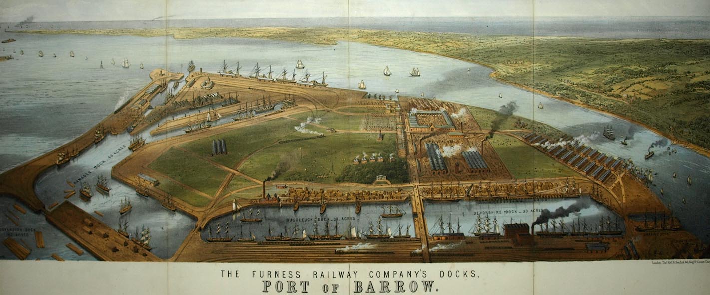 click to enlarge click to enlargeBPS81.jpg Aerial view. "THE FURNESS RAILWAY COMPANY'S DOCKS. / PORT OF BARROW." courtesy the Dock Museum |
||
|
|
||
 click to enlarge click to enlargePR0473.jpg |
||
|
|
||
Lakes Guides menu.