 Old Cumbria Gazetteer
 |
 |
|
| milestone, Staveley-in-Cartmel (3) | ||
| site name:- | road, Kendal to Ulverston | |
| site name:- | road, Lancaster to Ulverston | |
| locality:- | Ayside | |
| civil parish:- | Staveley-in-Cartmel (formerly Lancashire) | |
| county:- | Cumbria | |
| locality type:- | milestone | |
| coordinates:- | SD39348394 | |
| 1Km square:- | SD3983 | |
| 10Km square:- | SD38 | |
|
|
||
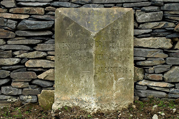 BPC49.jpg Inscribed stone:- "TO ULVERSTON 11 MLS BARROW 19¼ ,, / STAVELEY / TO GRANGE 4¾MLS KENDAL 15 ,, LANCASTER 26 ," The milestone has been rescued during recent road building; its position and altitude will have changed. (taken 26.4.2008) |
||
| Is this the right milestone for here? |
||
|
|
||
| evidence:- | old map:- OS County Series (Lan 12) |
|
| source data:- | Maps, County Series maps of Great Britain, scales 6 and 25
inches to 1 mile, published by the Ordnance Survey, Southampton,
Hampshire, from about 1863 to 1948. "M.S. ULVERSTON 10 MILNTHORPE 12" |
|
|
|
||
 Lakes Guides menu.