 Old Cumbria Gazetteer
 |
 |
|
| Monk Hall, Keswick | ||
| gone | ||
| Monk Hall | ||
| locality:- | Keswick | |
| civil parish:- | Keswick (formerly Cumberland) | |
| county:- | Cumbria | |
| locality type:- | building/s (built over) | |
| coordinates:- | NY26452408 | |
| 1Km square:- | NY2624 | |
| 10Km square:- | NY22 | |
| references:- | OS County Series |
|
|
|
||
| evidence:- | old map:- OS County Series (Cmd 64 2) placename:- Monk Hall |
|
| source data:- | Maps, County Series maps of Great Britain, scales 6 and 25
inches to 1 mile, published by the Ordnance Survey, Southampton,
Hampshire, from about 1863 to 1948. |
|
|
|
||
| evidence:- | old text:- Clarke 1787 placename:- Monks Hall item:- Furness Abbey |
|
| source data:- | Guide book, A Survey of the Lakes of Cumberland, Westmorland,
and Lancashire, written and published by James Clarke, Penrith,
Cumberland, and in London etc, 1787; published 1787-93. goto source goto sourcePage 100:- "..." "... Monks-Hall ... This estate belongs to Sir M. Le Fleming, Baronet, and takes its name from the circumstance of belonging formerly to the Monks of Furness Abbey in Lancashire. It was given to them, (with other lands in this neighbourhood,) by Godartus Dapifer, and was called a carucate of land. Godartus's heirs confirmed the gift, and paid, according to Nicholson and Burn, L.100, and five couples of hounds for a post-fine to King Henry II. At this hall the Monks had a Steward, and here the tenants used to pay their rents. It is now a small farm house, but there are vestiges of a moat and a square building." |
|
|
|
||
| evidence:- | old map:- Clarke 1787 map (Der) placename:- Monk Hall |
|
| source data:- | Map, uncoloured engraving, Map of Derwentwater and its Environs,
scale about 13 ins to 1 mile, by James Clarke, engraved by S J
Neele, published by James Clarke, Penrith, Cumberland and in
London etc, 1787.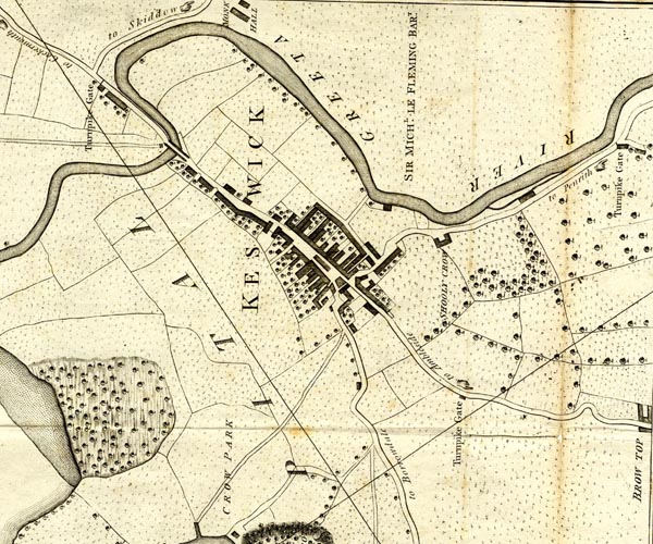 CL152623.jpg "MONK HALL" buildings item:- private collection : 169 Image © see bottom of page |
|
|
|
||
| evidence:- | old print:- Green 1822 (plate 28) placename:- Monk Hall item:- pump; water trough; porch; chimney |
|
| source data:- | Print, uncoloured soft ground etching, Monk Hall near Keswick, Cumberland, by William
Green, Ambleside, Westmorland, 1822.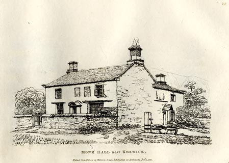 click to enlarge click to enlargeGN0828.jpg Plate 28 in Forty Etchings from Nature. printed at bottom:- "MONK HALL near KESWICK. / Etched from Nature by William Green, &Published at Ambleside, Feby. 1, 1822." item:- Armitt Library : A6644.28 Image © see bottom of page |
|
|
|
||
| evidence:- | old map:- Ford 1839 map placename:- Monk Hall |
|
| source data:- | Map, uncoloured engraving, Map of the Lake District of
Cumberland, Westmoreland and Lancashire, scale about 3.5 miles
to 1 inch, published by Charles Thurnam, Carlisle, and by R
Groombridge, 5 Paternoster Row, London, 3rd edn 1843.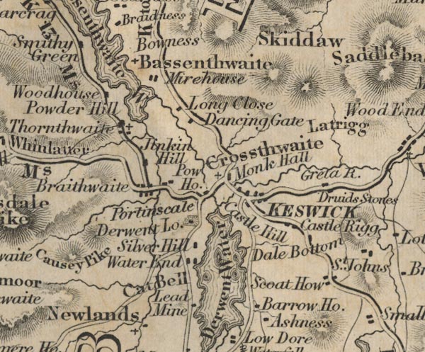 FD02NY22.jpg "Monk Hall" item:- JandMN : 100.1 Image © see bottom of page |
|
|
|
||
Lakes Guides menu.