 Old Cumbria Gazetteer
 |
 |
|
| Skelghyll, Lakes | ||
| Skelghyll | ||
| civil parish:- | Lakes (formerly Westmorland) | |
| county:- | Cumbria | |
| locality type:- | locality | |
| coordinates:- | NY38480288 (etc etc) | |
| 1Km square:- | NY3802 | |
| 10Km square:- | NY30 | |
|
|
||
| evidence:- | roughly descriptive text:- Otley 1823 (5th edn 1834) item:- geology |
|
| source data:- | Guide book, A Concise Description of the English Lakes, the
mountains in their vicinity, and the roads by which they may be
visited, with remarks on the mineralogy and geology of the
district, by Jonathan Otley, published by the author, Keswick,
Cumberland now Cumbria, by J Richardson, London, and by Arthur
Foster, Kirkby Lonsdale, Cumbria, 1823; published 1823-49,
latterly as the Descriptive Guide to the English Lakes. goto source goto sourcePage 158:- "The THIRD division - forming only inferior elevations - commences with a bed of dark-blue or blackish transition limestone, containing here and there a few shells and madrepores, and alternating with a slaty rock of the same colour; the different layers of each being in some places several feet, in others only a few inches in thickness. This limestone crosses the river Duddon near Broughton; passing Broughton Mills it runs in a north-east direction through Torver, by the foot of the Old Man mountain, and appears near Low Yewdale and Yew Tree. Here it makes a considerable slip to the eastward, after which it ranges past the Tarns upon the hills above Borwick Ground; and stretching through Skelwith, it crosses the head of Windermere near Low Wood Inn. Then passing above Dovenest and Skelgill, it traverses the vales of Troutbeck, Kentmere, and Long Sleddale;" |
|
|
|
||
| evidence:- | probably descriptive text:- Ford 1839 (3rd edn 1843) placename:- Skelgill |
|
| source data:- | Guide book, A Description of Scenery in the Lake District, by
Rev William Ford, published by Charles Thurnam, Carlisle, by W
Edwards, 12 Ave Maria Lane, Charles Tilt, Fleet Street, William
Smith, 113 Fleet Street, London, by Currie and Bowman,
Newcastle, by Bancks and Co, Manchester, by Oliver and Boyd,
Edinburgh, and by Sinclair, Dumfries, 1839. goto source Page 34:- "..." "WANSFELL AND SKELGILL." "Mountain excursions of moderate elevation, and almost without fatigue, may be made to Skelgill and Wansfell Pike, whence the localities of Ambleside are displayed as on a map, and thus the stranger is enabled to form a better idea of his position with regard to the mighty masses around him. Windermere, also, is seen in a new point of view." |
|
|
|
||
| evidence:- | old print:- Payn 1867 placename:- Skelgill |
|
| source data:- | Print, uncoloured engraving, Head of Windermere, from Skelgill, Westmorland, by T
L Aspland, published by J Garnett, Windermere, Westmorland, 1867.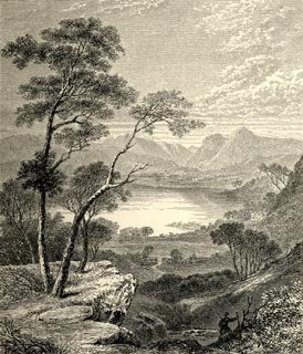 click to enlarge click to enlargePN0312.jpg On p.25 of The Lakes in Sunshine, text by James Payn. printed at bottom:- "HEAD OF WINDERMERE, FROM SKELGILL." item:- Fell and Rock Climbing Club : 184.12 Image © see bottom of page |
|
|
|
||
| evidence:- | old photograph:- Bell 1880s-1940s |
|
| source data:- | Photograph, b/w, Skelghyll, Westmorland, by Herbert Bell, Ambleside, Westmorland,
1890s?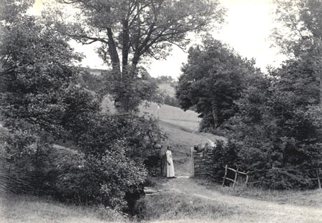 click to enlarge click to enlargeHB0309.jpg item:- Armitt Library : ALPS668 Image © see bottom of page |
|
|
|
||
Lakes Guides menu.