 Old Cumbria Gazetteer
 |
 |
|
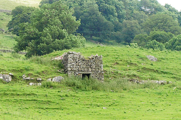
| limekiln, Dentdale | ||
| locality:- | Dentdale | |
| civil parish:- | Dent (formerly Yorkshire) | |
| county:- | Cumbria | |
| locality type:- | limekiln | |
| coordinates:- | SD72418669 | |
| 1Km square:- | SD7286 | |
| 10Km square:- | SD78 | |
|
|
||
 BQY33.jpg (taken 1.7.2009) |
||
|
|
||
| evidence:- | database:- Listed Buildings 2010 |
|
| source data:- | courtesy of English Heritage "LIME KILN APPROXIMATELY 100 METRES SOUTH EAST OF HIGH CHAPEL (CHAPEL NOT INCLUDED) / / / DENT / SOUTH LAKELAND / CUMBRIA / II / 484333 / SD7241286694" |
|
| source data:- | courtesy of English Heritage "Lime kiln. Probably later C19, and probably by a professional mason. Large coursed blocks of sandstone rubble, with quoins. Square plan, built against slope. Approx. 2.6 metres high, battered, and stepped back slightly above the draw hole, which is 1.75 metres high and slightly tapered. Some coping stones missing." "INTERIOR: round-ended draw hole with roof of 3 large stone slabs. Good example of its type, relatively well preserved; very similar to lime kiln approx. 100m south-west of High Croft (qv). Conspicuous feature of the landscape at this point in Dentdale." |
|
|
|
||
 Lakes Guides menu.