 Old Cumbria Gazetteer
 |
 |
|
| boundary stone, Casterton (2) | ||
| civil parish:- | Casterton (formerly Westmorland) | |
| county:- | Cumbria | |
| locality type:- | boundary stone | |
| locality type:- | county boundary mark | |
| coordinates:- | SD61997787 | |
| 1Km square:- | SD6177 | |
| 10Km square:- | SD67 | |
| county:- | Lancashire | |
| current boundary | ||
| locality:- | Cumbria boundary | |
| old boundary | ||
| locality:- | Westmorland boundary | |
|
|
||
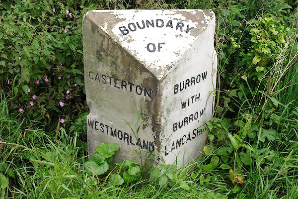 BRH18.jpg Inscribed stone:- "BOUNDARY / OF" "CASTERTON / WESTMORLAND" "BURROW / WITH / BURROW / LANCASHIRE" (taken 13.8.2009) |
||
|
|
||
| evidence:- | database:- Listed Buildings 2010 |
|
| source data:- | courtesy of English Heritage "BOUNDARY STONE APPROX 130M SOUTH OF THE A683 (SOUTH) JUNCTION / / A65 / CASTERTON / SOUTH LAKELAND / CUMBRIA / II / 75608 / SD6200977873" "BOUNDARY STONE / / A65 / BURROW WITH BURROW / LANCASTER / LANCASHIRE / II / 182335 / SD6200977877" |
|
| source data:- | courtesy of English Heritage "Boundary stone, probably mid C19th, sandstone. Triangular plan, with sloping top inscribed:'BOUNDARY OF'. Left-hand face inscribed: 'CASTERTON. WESTMORLAND'. Right-hand face inscribed: 'BURROW WITH BURROW. LANCASHIRE'. Part of this boundary stone is in Casterton C.P., Cumbria (q.v.)" |
|
| source data:- | courtesy of English Heritage "Boundary stone. Probably C19. Ashlar. Triangular stone with chamfered top. Inscribed: "BOUNDARY/OF", CASTERTON:BURROW/WITH/BURROW" and "WESTMORLAND : LANCASHIRE"." |
|
|
|
||
 Lakes Guides menu.