 Old Cumbria Gazetteer
 |
 |
|
| Bransty Turnpike, Whitehaven | ||
| Bransty Turnpike | ||
| site name:- | road, Cockermouth to Whitehaven | |
| Street:- | Bransty Road | |
| locality:- | Bransty | |
| civil parish:- | Whitehaven (formerly Cumberland) | |
| county:- | Cumbria | |
| locality type:- | toll gate (site) | |
| coordinates:- | NX97851991 | |
| 1Km square:- | NX9719 | |
| 10Km square:- | NX91 | |
| references:- | OS County Series |
|
|
|
||
| evidence:- | old map:- OS County Series (Cmd 61 14) |
|
| source data:- | Maps, County Series maps of Great Britain, scales 6 and 25
inches to 1 mile, published by the Ordnance Survey, Southampton,
Hampshire, from about 1863 to 1948. "Bransty T.P." gate across road and a building |
|
|
|
||
| evidence:- | old map:- Donald 1774 (Cmd) |
|
| source data:- | Map, hand coloured engraving, 3x2 sheets, The County of Cumberland, scale about 1
inch to 1 mile, by Thomas Donald, engraved and published by Joseph Hodskinson, 29
Arundel Street, Strand, London, 1774.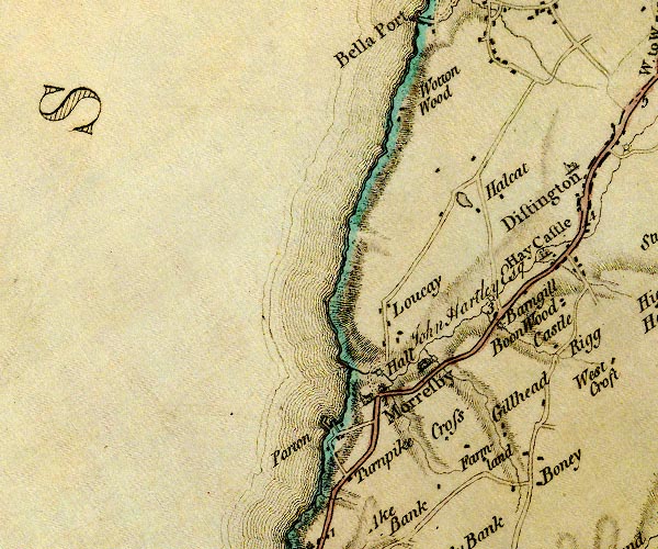 D4NX92SE.jpg "Turnpike" block by road between Whitehaven and Morseby; toll house and toll gate item:- Carlisle Library : Map 2 Image © Carlisle Library |
|
|
|
||
| evidence:- | database:- Listed Buildings 2010 placename:- Bransty Toll Bar item:- date stone (1854) |
|
| source data:- | courtesy of English Heritage "BRANSTY TOLL BAR / / BRANSTY ROAD / PARTON / COPELAND / CUMBRIA / II / 76151 / NX9781419882" |
|
|
|
||
 Lakes Guides menu.