 Old Cumbria Gazetteer
 |
 |
|
| milestone, Bridekirk (2) | ||
| site name:- | road, Cockermouth to Maryport | |
| civil parish:- | Bridekirk (formerly Cumberland) | |
| county:- | Cumbria | |
| locality type:- | milestone | |
| coordinates:- | NY09213389 | |
| 1Km square:- | NY0933 | |
| 10Km square:- | NY03 | |
|
|
||
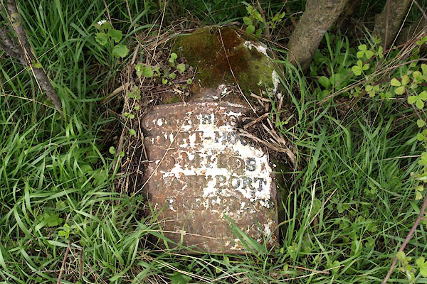 BWH99.jpg (lying down) "COCKERMOUTH / COURT HOU[SE] / 3 MILES / MARY PORT / MARKET PLACE / [ ]" (taken 4.5.2012) |
||
|
|
||
| evidence:- | old map:- OS County Series (Cmd 45 11) |
|
| source data:- | Maps, County Series maps of Great Britain, scales 6 and 25
inches to 1 mile, published by the Ordnance Survey, Southampton,
Hampshire, from about 1863 to 1948. "Cockermouth .. 3 Maryport .. 4 1/4 M.S" |
|
|
|
||
| evidence:- | database:- Listed Buildings 2010 |
|
| source data:- | courtesy of English Heritage "MILESTONE NORTH OF DOVENBY / / / BRIDEKIRK / ALLERDALE / CUMBRIA / II / 72585 / NY0921533894" |
|
| source data:- | courtesy of English Heritage "Milestone. Late C18 or early C19 for the Cockermouth-Maryport Turnpike. Whitewashed stone with rounded top; attached to curved face a cast iron plate inscribed COCKERMOUTH COURT-HOUSE 3 MILES, MARYPORT MARKET PLACE 4 1/2 MILES, the lettering picked out in black." |
|
|
|
||
 Lakes Guides menu.