 Old Cumbria Gazetteer
 |
 |
|
| milestone, Broughton East | ||
| site name:- | road, ? | |
| civil parish:- | Broughton East (formerly Lancashire) | |
| county:- | Cumbria | |
| locality type:- | milestone | |
| coordinates:- | SD38908010 | |
| 1Km square:- | SD3880 | |
| 10Km square:- | SD38 | |
|
|
||
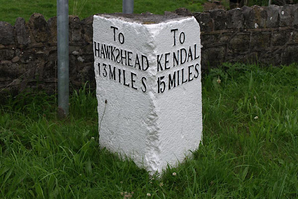 BTG13.jpg Inscribed stone, letters in relief:- "To HAWKSHEAD 13 MILES / To KENDAL 15 MILES" (taken 30.7.2010) |
||
|
|
||
| evidence:- | old map:- OS County Series (Lan 12) |
|
| source data:- | Maps, County Series maps of Great Britain, scales 6 and 25
inches to 1 mile, published by the Ordnance Survey, Southampton,
Hampshire, from about 1863 to 1948. "HAWKSHEAD 13 KENDAL 15 M.S." |
|
|
|
||
| evidence:- | database:- Listed Buildings 2010 |
|
| source data:- | courtesy of English Heritage "MILESTONE APPROXIMATELY 100 METRES TO WEST OF LONGLANDS FARM / / / BROUGHTON EAST / SOUTH LAKELAND / CUMBRIA / II / 76914 / SD3890080101" |
|
| source data:- | courtesy of English Heritage "Milestone. C18. Stone. Triangular plan, with one angle removed. Left face has panel reading: "TO/HAWKSHEAD/13 MILES" (the S of Hawkshead reversed). Right face has panel reading: "TO/KENDAL/15 MILES"." |
|
|
|
||
 Lakes Guides menu.