 Old Cumbria Gazetteer
 |
 |
|
| toll gate, Nether Staveley | ||
| gone | ||
| site name:- | road, Kendal to Windermere | |
| locality:- | New Bridge | |
| locality:- | Staveley | |
| civil parish:- | Nether Staveley (formerly Westmorland) | |
| county:- | Cumbria | |
| locality type:- | toll gate (site) | |
| coordinates:- | SD47229800 | |
| 1Km square:- | SD4798 | |
| 10Km square:- | SD49 | |
|
|
||
| evidence:- | old map:- OS County Series (Wmd 33 6) placename:- |
|
| source data:- | Maps, County Series maps of Great Britain, scales 6 and 25
inches to 1 mile, published by the Ordnance Survey, Southampton,
Hampshire, from about 1863 to 1948. "T.P." |
|
|
|
||
| evidence:- | old map:- Jefferys 1770 (Wmd) |
|
| source data:- | Map, 4 sheets, The County of Westmoreland, scale 1 inch to 1
mile, surveyed 1768, and engraved and published by Thomas
Jefferys, London, 1770.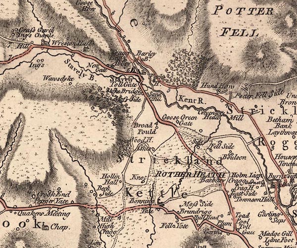 J5SD49NE.jpg "Toll Gate" circle item:- National Library of Scotland : EME.s.47 Image © National Library of Scotland |
|
|
|
||
| evidence:- | notice:- placename:- Staveley Toll Gate |
|
| source data:- | "AMBLESIDE Turnpike Road. / Tolls to Let. / ... the Tolls arising at the Toll Gates
upon the Ambleside Turnpike Road, called and known by the names of PLUMGARTHS, STAVELEY,
BONNINGATE CHAIN, WATER HEAD, and GRASMERE TOLL GATES, will be Let by Auction, ...
at the House of Mr.JOSEPH BARROW, the Commercial Inn, in Kendal ... which Tolls produced
the last year as follows, that is to say,- / Plumgarths and Staveley Gate, with Bonningate
Chain ... L331 / Waterhead Gate and Grasmere Gate ... L680 / Above the expenses of
collecting them , ... / WILLIAM PETTY, Clerk to the Trustees ... Kendal, August 24th,
1854. / T. ATKINSON, PRINTER, KENDAL." |
|
|
|
||
 Lakes Guides menu.