Old Cumbria Gazetteer
 |
 |
|
||
| included in:- |
 road, Penrith to Hexham road, Penrith to Hexham |
|||
| road, Alston to Hexham | ||||
| Alston to Hexham | ||||
| Hexham to Alston | ||||
| A686 | ||||
| civil parish:- | Alston Moor (formerly Cumberland) | |||
| county:- | Cumbria | |||
| locality type:- | route | |||
| 10Km square:- | NY74 | |||
| 10Km square:- | NY75 | |||
| county:- | Northumberland | |||
| locality type:- | route | |||
| 10Km square:- | NY75 (etc) | |||
|
|
||||
| evidence:- | old map:- Bowen and Kitchin 1760 |
|||
| source data:- | Map, hand coloured engraving, A New Map of the Counties of
Cumberland and Westmoreland Divided into their Respective Wards,
scale about 4 miles to 1 inch, by Emanuel Bowen and Thomas
Kitchin et al, published by T Bowles, Robert Sayer, and John
Bowles, London, 1760.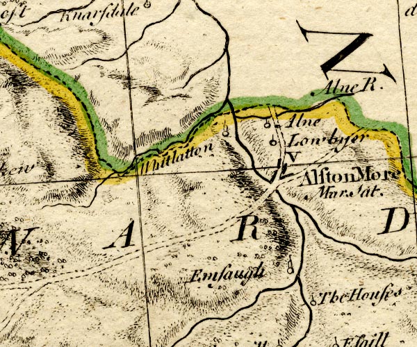 BO18NY74.jpg double line, dotted item:- Armitt Library : 2008.14.10 Image © see bottom of page |
|||
|
|
||||
| evidence:- | road map:- Cary 1790 (Nhd/edn 1806) |
|||
| source data:- | Road map, hand coloured engraving, Northumberland, scale about
17.5 miles to 1 inch, by John Cary, 181 Strand, London, 1790,
edn 1806.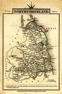 click to enlarge click to enlargeCY45.jpg double line item:- JandMN : 417 Image © see bottom of page |
|||
|
|
||||
| evidence:- | road map:- Cary 1790 (Cmd/edn 1789) |
|||
| source data:- | Road map, hand coloured engraving, Cumberland, scale about 15
miles to 1 inch, by John Cary, 181 Strand, London, 1790, edn
1789.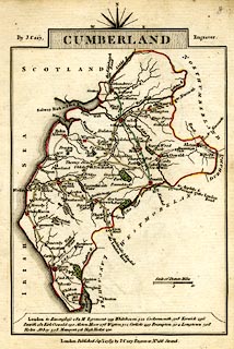 click to enlarge click to enlargeCY47.jpg "to Newcastle" double line item:- JandMN : 419 Image © see bottom of page |
|||
|
|
||||
| evidence:- | road book:- Cary 1798 (2nd edn 1802) |
|||
| source data:- | Road book, itineraries, Cary's New Itinerary, by John Cary, 181
Strand, London, 2nd edn 1802. goto source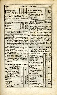 click to enlarge click to enlargeC38697.jpg page 697-698 "At Fairshaw T.G. on l. a T.R. to Aldstone Moor." item:- JandMN : 228.2 Image © see bottom of page |
|||
|
|
||||
| evidence:- | old map:- Cooke 1802 |
|||
| source data:- | Map, Cumberland, scale about 15.5 miles to 1 inch, by George
Cooke, 1802, bound in Gray's New Book of Roads, 1824, published
by Sherwood, Jones and Co, Paternoster Road, London, 1824. click to enlarge click to enlargeGRA1Cd.jpg "to Newcastle thro Hexham" double line, light dark solid; road item:- Hampshire Museums : FA2000.62.2 Image © see bottom of page |
|||
|
|
||||
| evidence:- | old map:- Laurie and Whittle 1806 |
|||
| source data:- | Road map, Continuation of the Roads to Glasgow and Edinburgh,
scale about 10 miles to 1 inch, by Nathaniel Coltman? 1806,
published by Robert H Laurie, 53 Fleet Street, London, 1834. click to enlarge click to enlargeLw21.jpg "Aldstone to Hexham 20" dotted line; 'Cross Roads' item:- private collection : 18.21 Image © see bottom of page |
|||
|
|
||||
| evidence:- | gradient diagram:- Gall and Inglis 1890s-1900s (Roads) |
|||
| source data:- | Contour Road Book of England, Northern Division, by Harry R G Inglis, published by
Gall and Inglis, 25 Paternoster Square, London and Edinburgh, 1898.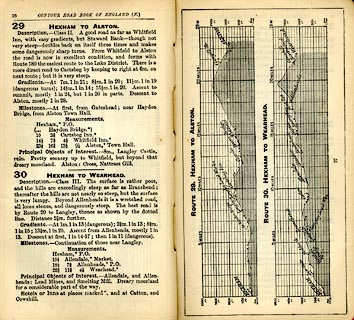 click to enlarge click to enlargeIG5029.jpg Itinerary, with gradient diagram, route 29, Hexham to Alston, Northumberland and Cumberland, 1898. item:- JandMN : 763.3 Image © see bottom of page |
|||
|
|
||||
| evidence:- | old strip map:- CTC 1911 (Roads) |
|||
| source data:- | Page 91 of Cyclists' Touring Club British Road Book new series vol.6, edited by F
B Sandford, published by Thomas Nelson and Sons, London etc, 1911.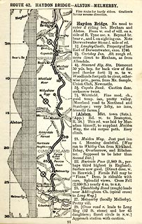 click to enlarge click to enlargeCTC291.jpg Strip road map, route 42, Haydon Bridge Alston Melmerby, part of Haydon Bridge to Grange-over-Sands, scale roughly 5 miles to 1 inch. Together with an itinerary and gradient diagram. item:- JandMN : 491.91 Image © see bottom of page |
|||
|
|
||||
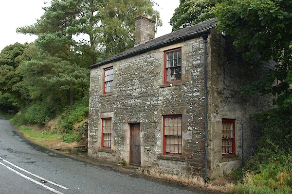
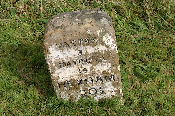
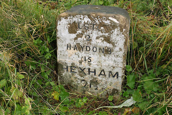
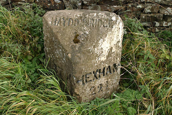
| places:- | Alston Hexham, Northumberland |
|||
|
|
||||
| places:- |
|
|||
|
||||
|
||||
|
||||
|
||||
Lakes Guides menu.