 Old Cumbria Gazetteer
 |
 |
|
| Thorney Stone, Boltons | ||
| Thorney Stone | ||
| civil parish:- | Boltons (formerly Cumberland) | |
| civil parish:- | Caldbeck (formerly Cumberland) | |
| county:- | Cumbria | |
| locality type:- | stone | |
| locality type:- | boundary mark | |
| locality type:- | parish boundary mark | |
| coordinates:- | NY27563820 | |
| 1Km square:- | NY2738 | |
| 10Km square:- | NY23 | |
| references:- | OS County Series |
|
|
|
||
| evidence:- | old map:- OS County Series (Cmd 37 14) placename:- Thorny Stone |
|
| source data:- | Maps, County Series maps of Great Britain, scales 6 and 25
inches to 1 mile, published by the Ordnance Survey, Southampton,
Hampshire, from about 1863 to 1948. "Thorny Stone" |
|
|
|
||
| evidence:- | old map:- Donald 1774 (Cmd) placename:- Thorney Stone |
|
| source data:- | Map, hand coloured engraving, 3x2 sheets, The County of Cumberland, scale about 1
inch to 1 mile, by Thomas Donald, engraved and published by Joseph Hodskinson, 29
Arundel Street, Strand, London, 1774.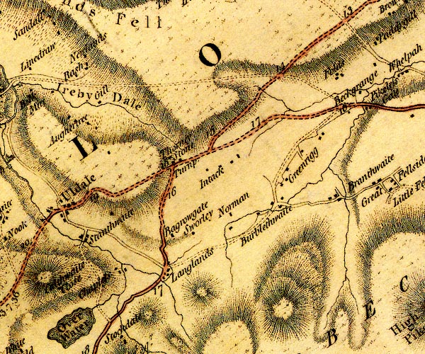 D4NY23NE.jpg "Thorney Stone" block or blocks, labelled in lowercase; a hamlet or just a house item:- Carlisle Library : Map 2 Image © Carlisle Library |
|
|
|
||
| evidence:- | road book:- Cary 1798 (2nd edn 1802) placename:- Thorney Stone |
|
| source data:- | Road book, itineraries, Cary's New Itinerary, by John Cary, 181
Strand, London, 2nd edn 1802. goto source goto source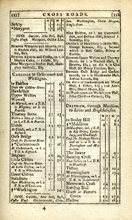 click to enlarge click to enlargeC38557.jpg page 557-558 "Thorney Stone" item:- JandMN : 228.2 Image © see bottom of page |
|
|
|
||
| evidence:- | old map:- Cooke 1802 placename:- Thorney Stone |
|
| source data:- | Map, Cumberland, scale about 15.5 miles to 1 inch, by George
Cooke, 1802, bound in Gray's New Book of Roads, 1824, published
by Sherwood, Jones and Co, Paternoster Road, London, 1824. click to enlarge click to enlargeGRA1Cd.jpg "Thorney Stone" no symbol item:- Hampshire Museums : FA2000.62.2 Image © see bottom of page |
|
|
|
||
| evidence:- | old map:- Laurie and Whittle 1806 placename:- Thorney Stone |
|
| source data:- | Road map, Completion of the Roads to the Lakes, scale about 10
miles to 1 inch, by Nathaniel Coltman? 1806, published by Robert
H Laurie, 53 Fleet Street, London, 1834. click to enlarge click to enlargeLw18.jpg "Thorney Stone" item:- private collection : 18.18 Image © see bottom of page |
|
|
|
||
| evidence:- | old map:- Wallis 1810 (Cmd) |
|
| source data:- | Road map, hand coloured engraving, Cumberland, scale about 16
miles to 1 inch, by James Wallis, 77 Berwick Stree, Soho,
London, 1810. click to enlarge click to enlargeWL13.jpg "Thor[ue ] Stone" village, hamlet, house, ... item:- Dove Cottage : 2009.81.10 Image © see bottom of page |
|
|
|
||
Lakes Guides menu.