 Old Cumbria Gazetteer
 |
 |
|
| windmill, Monkhill | ||
| Street:- | Vallum Place | |
| locality:- | Monkhill | |
| civil parish:- | Beaumont (formerly Cumberland) | |
| county:- | Cumbria | |
| locality type:- | windmill (ex) | |
| locality type:- | mill (ex) | |
| coordinates:- | NY34305858 | |
| 1Km square:- | NY3458 | |
| 10Km square:- | NY35 | |
| references:- | OS County Series |
|
|
|
||
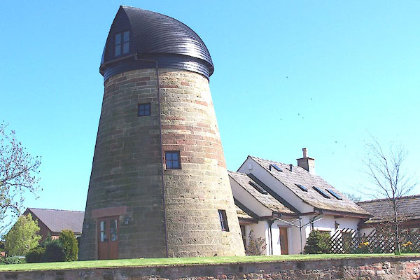 BMA81.jpg House converted from a tower mill. (taken 5.5.2006) |
||
|
|
||
| evidence:- | old map:- OS County Series (Cmd 16) |
|
| source data:- | Maps, County Series maps of Great Britain, scales 6 and 25
inches to 1 mile, published by the Ordnance Survey, Southampton,
Hampshire, from about 1863 to 1948. "Windmill" |
|
|
|
||
| evidence:- | database:- Listed Buildings 2010 placename:- Monkhill Windmill |
|
| source data:- | courtesy of English Heritage "MONKHILL WINDMILL / / / BEAUMONT / CARLISLE / CUMBRIA / II / 78209 / NY3430458580" |
|
| source data:- | courtesy of English Heritage "Former windmill. Late C18. Red sandstone ashlar. 3 storeys, conical shape. 2 ground floor entrances with wooden lintels. Window openings on 3 levels. Roof and sails missing; derelict and unoccupied at time of survey. See Transactions Cumberland & Westmorland Antiquarian &Archaeological Society, new series, lxxii, pp129-132." |
|
|
|
||
 Lakes Guides menu.