 Old Cumbria Gazetteer
 |
 |
|
| Brackenhill Farm, Arthuret | ||
| Brackenhill Farm | ||
| locality:- | Brackenhill | |
| civil parish:- | Arthuret (formerly Cumberland) | |
| county:- | Cumbria | |
| locality type:- | buildings | |
| coordinates:- | NY44556947 | |
| 1Km square:- | NY4469 | |
| 10Km square:- | NY46 | |
| references:- | Listed Buildings 2010 |
|
|
|
||
| evidence:- | old map:- Donald 1774 (Cmd) placename:- Brackenhill |
|
| source data:- | Map, hand coloured engraving, 3x2 sheets, The County of Cumberland, scale about 1
inch to 1 mile, by Thomas Donald, engraved and published by Joseph Hodskinson, 29
Arundel Street, Strand, London, 1774.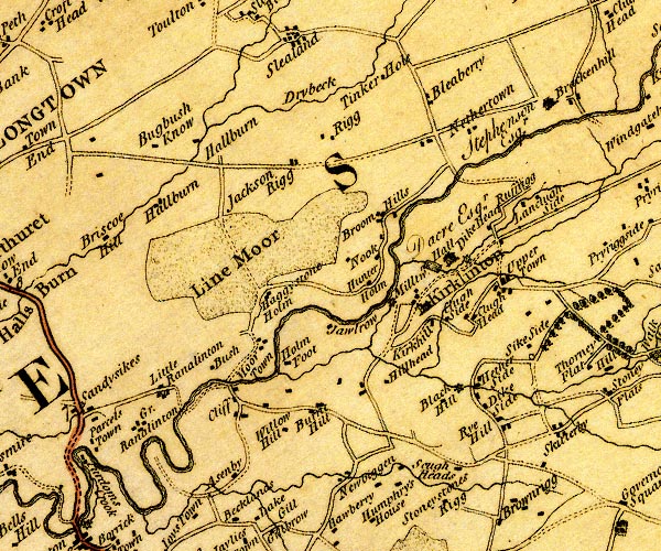 D4NY46NW.jpg "Brackenhill / Stephenson Esqr." house item:- Carlisle Library : Map 2 Image © Carlisle Library |
|
|
|
||
| evidence:- | probably old map:- Cooper 1808 placename:- Breckonhill |
|
| source data:- | Map, uncoloured engraving, Cumberland, scale about 10.5 miles to
1 inch, drawn and engraved by Cooper, published by R Phillips,
Bridge Street, Blackfriars, London, 1808. click to enlarge click to enlargeCOP3.jpg "Breckonhill" circle; village or hamlet item:- JandMN : 86 Image © see bottom of page |
|
|
|
||
| evidence:- | database:- Listed Buildings 2010 placename:- Brackenhill Farm |
|
| source data:- | courtesy of English Heritage "BRACKENHILL FARMHOUSE / / / ARTHURET / CARLISLE / CUMBRIA / II / 78084 / NY4455969470" |
|
|
|
||
| evidence:- | database:- Listed Buildings 2010 |
|
| source data:- | courtesy of English Heritage "BARNS TO NORTH WEST OF BRACKENHILL FARMHOUSE / / / ARTHURET / CARLISLE / CUMBRIA / II / 78086 / NY4450969497" |
|
|
|
||
 Lakes Guides menu.