 Old Cumbria Gazetteer
 |
 |
|
| limekiln, Rampside | ||
| locality:- | Rampside | |
| civil parish:- | Barrow-in-Furness (formerly Lancashire) | |
| county:- | Cumbria | |
| locality type:- | limekiln | |
| coordinates:- | SD23886613 (estimate) | |
| 1Km square:- | SD2366 | |
| 10Km square:- | SD26 | |
|
|
||
| evidence:- | old map:- OS County Series (Lan 28) |
|
| source data:- | Maps, County Series maps of Great Britain, scales 6 and 25
inches to 1 mile, published by the Ordnance Survey, Southampton,
Hampshire, from about 1863 to 1948. "Limekiln" |
|
|
|
||
| evidence:- | old print:- Gibson 1851 |
|
| source data:- | Print, engraving, Piel Pier, Rampside, with Barrow in the Distance, from the Sea,
Lancashire, published by J Jackson, Market Place, Ulverston, Lancashire, and by Whittaker
and Co, London, 1851.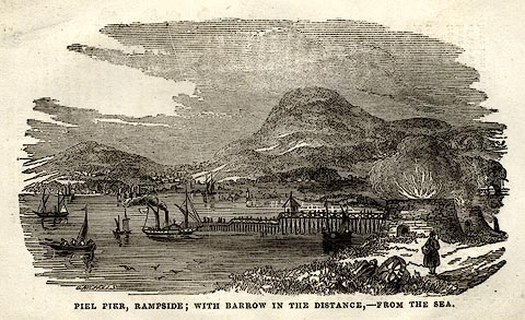 click to enlarge click to enlargeGB05E5.jpg On p.89 of a Hand Book to The Lakes, by James Gibson. printed at bottom:- "PIEL PIER, RAMPSIDE; WITH BARROW IN THE DISTANCE, - FROM THE SEA." item:- Armitt Library : A1131.7 Image © see bottom of page |
|
|
|
||
 Lakes Guides menu.