 Old Cumbria Gazetteer
 |
 |
|
| mine, Stank | ||
| out of sight | ||
| locality:- | Stank | |
| civil parish:- | Barrow-in-Furness (formerly Lancashire) | |
| county:- | Cumbria | |
| locality type:- | iron mine | |
| locality type:- | mine | |
| coordinates:- | SD23217073 | |
| 1Km square:- | SD2370 | |
| 10Km square:- | SD27 | |
| references:- | Listed Buildings 2010 |
|
|
|
||
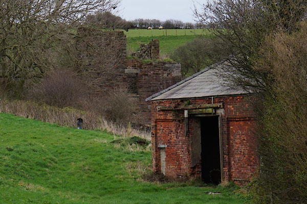 CAG59.jpg (taken 4.4.2014) |
||
|
|
||
| evidence:- | old map:- OS County Series (Lan 22 5) placename:- Stank Iron Mines |
|
| source data:- | Maps, County Series maps of Great Britain, scales 6 and 25
inches to 1 mile, published by the Ordnance Survey, Southampton,
Hampshire, from about 1863 to 1948. |
|
|
|
||
| evidence:- | database:- Listed Buildings 2010 |
|
| source data:- | courtesy of English Heritage "ENGINE HOUSE AT NGR SD 2325 7080 TO NORTH EAST OF GLENFIELD HOUSE / / STANK / BARROW IN FURNESS / BARROW IN FURNESS / CUMBRIA / II / 388359 / SD2327370782" |
|
| source data:- | courtesy of English Heritage "Engine house for iron-ore mine. c1875. Rock-faced red sandstone with limestone plinth and dressings. 3-stage square tower now semi-ruined. Plinth, large quoins. South-east side: impost band to narrow round-arched opening with limestone voussoirs. Opposite side has larger round arch in sandstone beneath broad opening with collapsed limestone lintels. South-west side: 2 doorways beneath rectangular opening; all have limestone lintels. 3rd stage incomplete. Served Stank No.2 pit developed 1873-76, abandoned January 1901 due to severe flooding problems (Trescatheric). (Trescatheric B: Roose: A Cornish Village in Furness: Barrow in Furness: 1983-: 5, 32)." |
|
|
|
||
| evidence:- | database:- Listed Buildings 2010 |
|
| source data:- | courtesy of English Heritage "FORMER MINE BUILDING IMMEDIATELY TO NORTH OF GLENFIELD HOUSE / / STANK / BARROW IN FURNESS / BARROW IN FURNESS / CUMBRIA / II / 388360 / SD2321570735" |
|
|
|
||
 Lakes Guides menu.