 Old Cumbria Gazetteer
 |
 |
|
| Nunnery, Ainstable | ||
| Nunnery | ||
| Armathwaite Nunnery | ||
| civil parish:- | Ainstable (formerly Cumberland) | |
| county:- | Cumbria | |
| locality type:- | buildings | |
| locality type:- | locality | |
| locality type:- | religious house (ex) | |
| locality type:- | nunnery (ex) | |
| coordinates:- | NY53724285 (etc) | |
| 1Km square:- | NY5342 | |
| 10Km square:- | NY54 | |
|
|
||
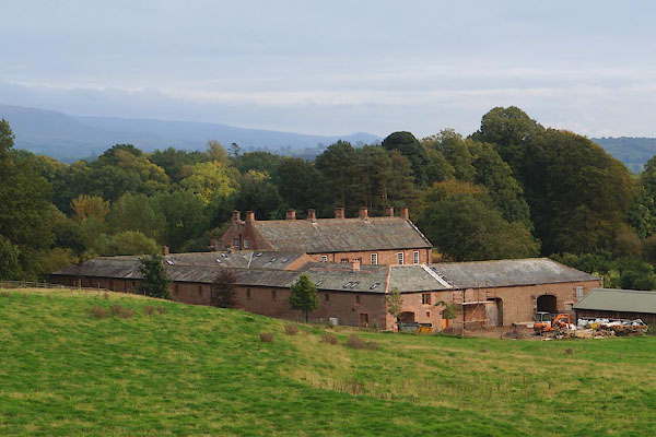 CEB30.jpg (taken 9.10.2015) 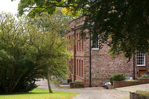 CEB31.jpg (taken 9.10.2015) |
||
|
|
||
| evidence:- | old map:- OS County Series (Cmd 40) placename:- Armathwaite Nunnery |
|
| source data:- | Maps, County Series maps of Great Britain, scales 6 and 25
inches to 1 mile, published by the Ordnance Survey, Southampton,
Hampshire, from about 1863 to 1948. "Site of Armathwaite Nunnery" |
|
|
|
||
| evidence:- | map:- |
|
| source data:- | : 1954: Monastic Britain: Ordnance Survey | |
|
|
||
| evidence:- | old map:- Saxton 1579 placename:- Nunnye |
|
| source data:- | Map, hand coloured engraving, Westmorlandiae et Cumberlandiae Comitatus ie Westmorland
and Cumberland, scale about 5 miles to 1 inch, by Christopher Saxton, London, engraved
by Augustinus Ryther, 1576, published 1579-1645.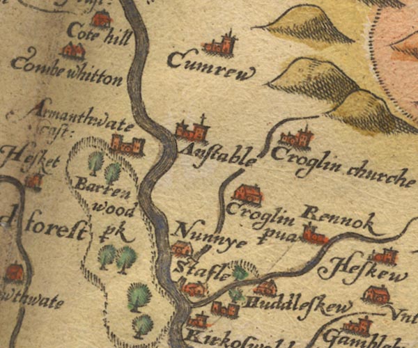 Sax9NY54.jpg Building, symbol for a hamlet, which may or may not have a nucleus. "Nunnye" item:- private collection : 2 Image © see bottom of page |
|
|
|
||
| evidence:- | old map:- Mercator 1595 (edn?) placename:- Nunnye |
|
| source data:- | Map, hand coloured engraving, Northumbria, Cumberlandia, et
Dunelmensis Episcopatus, ie Northumberland, Cumberland and
Durham etc, scale about 6.5 miles to 1 inch, by Gerard Mercator,
Duisberg, Germany, about 1595.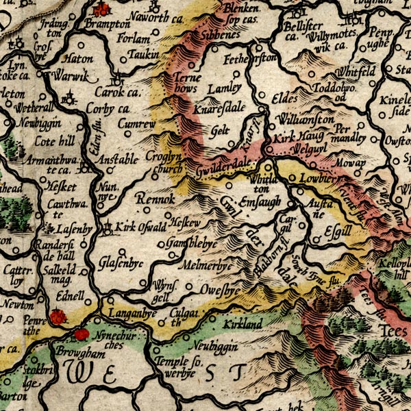 MER8CumD.jpg "Nunnye" circle item:- JandMN : 169 Image © see bottom of page |
|
|
|
||
| evidence:- | old map:- Speed 1611 (Cmd) placename:- Nunny |
|
| source data:- | Map, hand coloured engraving, Cumberland and the Ancient Citie
Carlile Described, scale about 4 miles to 1 inch, by John Speed,
1610, published by J Sudbury and George Humble, Popes Head
Alley, London, 1611-12.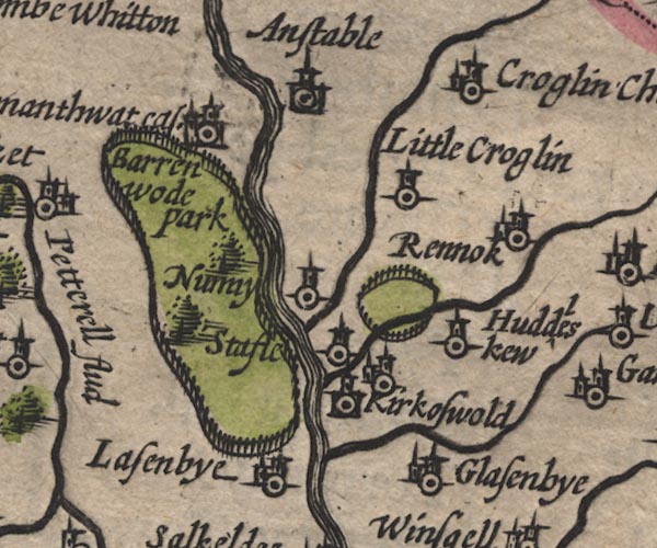 SP11NY54.jpg "Nunny" circle, tower item:- private collection : 16 Image © see bottom of page |
|
|
|
||
| evidence:- | old map:- Jansson 1646 placename:- Nunny |
|
| source data:- | Map, hand coloured engraving, Cumbria and Westmoria, ie
Cumberland and Westmorland, scale about 3.5 miles to 1 inch, by
John Jansson, Amsterdam, Netherlands, 1646.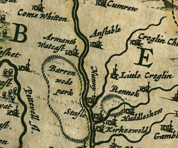 JAN3NY54.jpg "Nunny" Buildings and tower. item:- JandMN : 88 Image © see bottom of page |
|
|
|
||
| evidence:- | old map:- Morden 1695 (Cmd) placename:- Nunnery |
|
| source data:- | Map, uncoloured engraving, Cumberland, scale about 4 miles to 1
inch, by Robert Morden, 1695, published by Abel Swale, the
Unicorn, St Paul's Churchyard, Awnsham, and John Churchill, the
Black Swan, Paternoster Row, London, 1695-1715.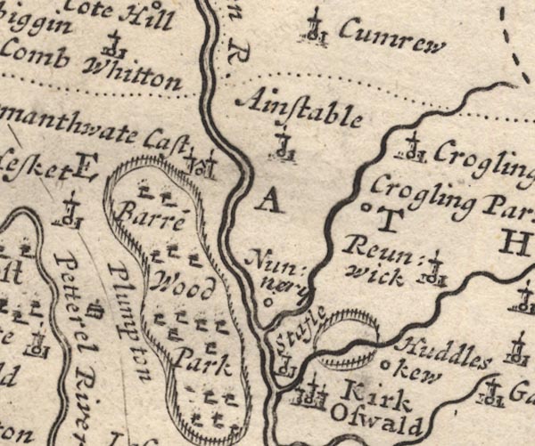 MD12NY54.jpg "Nunnery" Circle. item:- JandMN : 90 Image © see bottom of page |
|
|
|
||
| evidence:- | probably old map:- Bowen and Kitchin 1760 placename:- Runny |
|
| source data:- | Map, hand coloured engraving, A New Map of the Counties of
Cumberland and Westmoreland Divided into their Respective Wards,
scale about 4 miles to 1 inch, by Emanuel Bowen and Thomas
Kitchin et al, published by T Bowles, Robert Sayer, and John
Bowles, London, 1760.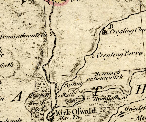 BO18NY54.jpg "Runny" circle and line item:- Armitt Library : 2008.14.10 Image © see bottom of page |
|
|
|
||
| evidence:- | old map:- Donald 1774 (Cmd) placename:- Nunnery |
|
| source data:- | Map, hand coloured engraving, 3x2 sheets, The County of Cumberland, scale about 1
inch to 1 mile, by Thomas Donald, engraved and published by Joseph Hodskinson, 29
Arundel Street, Strand, London, 1774.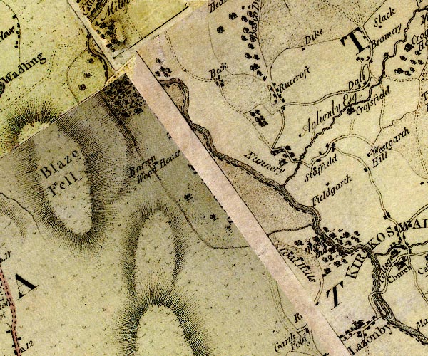 D4NY54SW.jpg "Nunnery" house item:- Carlisle Library : Map 2 Image © Carlisle Library |
|
|
|
||
| evidence:- | descriptive text:- Nicolson and Burn 1777 placename:- Nunnery |
|
| source data:- | Book, History and Antiquities of the Counties of Westmorland and
Cumberland, 2 volumes, by Joseph Nicolson and Richard Burn,
published by W Strahan and T Cadell, Strand, London, 1777.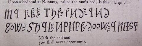 click to enlarge click to enlargeBMZ74.jpg "Upon a bedhead at Nunnery, called the nun's bed, is this inscription;Mark the end and yow shall never doow amis." |
|
|
|
||
| evidence:- | old text:- Camden 1789 (Gough Additions) |
|
| source data:- | Book, Britannia, or A Chorographical Description of the Flourishing Kingdoms of England,
Scotland, and Ireland, by William Camden, 1586, translated from the 1607 Latin edition
by Richard Gough, published London, 1789. goto source goto sourcePage 191:- "..." "Nunnery in Ainstable parish was a small house of Benedictine nuns, founded by William Rufus a.r. 2. At the dissolution here were only a prioress and three nuns, and their ample revenues were reduced to £.18. 18s. per annum. It was granted to William Graham, and passed by exchange to the Aglionbys present owners. On the head of a bed called the Nun's bed, is the rude inscription. Pl.X. fig.8." |
|
|
|
||
| evidence:- | old map:- Ford 1839 map placename:- Nunnery |
|
| source data:- | Map, uncoloured engraving, Map of the Lake District of
Cumberland, Westmoreland and Lancashire, scale about 3.5 miles
to 1 inch, published by Charles Thurnam, Carlisle, and by R
Groombridge, 5 Paternoster Row, London, 3rd edn 1843.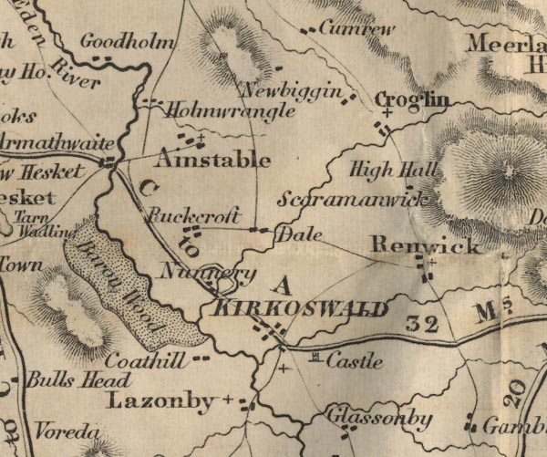 FD02NY54.jpg "Nunnery" item:- JandMN : 100.1 Image © see bottom of page |
|
|
|
||
| evidence:- | database:- Listed Buildings 2010 placename:- Nunnery, The item:- date stone (1694) |
|
| source data:- | courtesy of English Heritage "THE NUNNERY / / / AINSTABLE / EDEN / CUMBRIA / I / 73441 / NY5372642849" |
|
|
|
||
| evidence:- | database:- Listed Buildings 2010 |
|
| source data:- | courtesy of English Heritage "STABLE BLOCK TO NORTH WEST OF THE NUNNERY / / / AINSTABLE / EDEN / CUMBRIA / II / 73442 / NY5372442878" |
|
|
|
||
| evidence:- | database:- Listed Buildings 2010 |
|
| source data:- | courtesy of English Heritage "SUMMER HOUSE SOUTH OF THE NUNNERY / / / AINSTABLE / EDEN / CUMBRIA / II / 73443 / NY5366742386" |
|
| source data:- | courtesy of English Heritage "Summer House. Early C19, incorporating early C15 features, C20 roof. Sandstone rubble walls, carved red sandstone panels; timber roof with asphalt covering. Small open fronted building with wooden seats inside. Rear wall has 8 panels of coats of arms, 5 of which are thought to have come to The Nunnery in 1778 from a tomb to the Denton family in St Cuthbert's Church, Carlisle. Arms are thought to be of the Dentons, Skelton of Branthwaite conjoined with Copeland, Copeland conjoined with Denton, Curwen and one undetermined being badly weathered. See, Transactions Cumberland & Westmorland Antiquarian &Archaeological Society, new series, vol xvii, p.13-15." |
|
|
|
||
| hearsay:- |
Built by Henry Aglionby, 1715, but the rear of the building is said to include parts
of a Benedictine nunnery of the early 13th century. |
|
|
|
||
Lakes Guides menu.