 Old Cumbria Gazetteer
 |
 |
|
| Old Fallbarrow, Windermere | ||
| Old Fallbarrow | ||
| Street:- | Fallbarrow Road | |
| civil parish:- | Windermere (formerly Westmorland) | |
| county:- | Cumbria | |
| locality type:- | buildings | |
| coordinates:- | SD40169706 | |
| 1Km square:- | SD4097 | |
| 10Km square:- | SD49 | |
| references:- | Listed Buildings 2010 |
|
|
|
||
| evidence:- | perhaps old map:- OS County Series (Wmd 32 11) placename:- Fallbarrow |
|
| source data:- | Maps, County Series maps of Great Britain, scales 6 and 25
inches to 1 mile, published by the Ordnance Survey, Southampton,
Hampshire, from about 1863 to 1948. |
|
|
|
||
| evidence:- | perhaps old map:- Prior 1874 map 1 placename:- Fallbarrow |
|
| source data:- | Map, uncoloured engraving or lithograph? Winander Mere, scale
about 2.5 miles to 1 inch, published by John Garnett,
Windermere, Westmorland, 1874.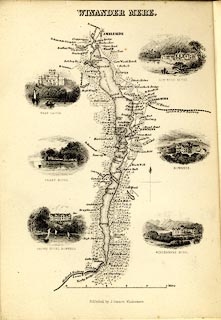 click to enlarge click to enlargePI03M1.jpg "Fallbarrow" block/s; building/s item:- private collection : 133.1 Image © see bottom of page |
|
|
|
||
| evidence:- | database:- Listed Buildings 2010 placename:- Old Fallbarrow |
|
| source data:- | courtesy of English Heritage "OLD FALLBARROW / / FALLBARROW ROAD / WINDERMERE TOWN / SOUTH LAKELAND / CUMBRIA / II / 351670 / SD4016197064" |
|
|
|
||
| evidence:- | database:- Listed Buildings 2010 |
|
| source data:- | courtesy of English Heritage "BARN TO SOUTH WEST OF OLD FALLBARROW / / FALLBARROW ROAD / WINDERMERE TOWN / SOUTH LAKELAND / CUMBRIA / II / 351671 / SD4014697048" |
|
|
|
||
 Lakes Guides menu.