 Old Cumbria Gazetteer
 |
 |
|
| Old Mill, Lessonhall | ||
| Old Mill | ||
| site name:- | Waver, River (?) | |
| locality:- | Lessonhall | |
| civil parish:- | Waverton (formerly Cumberland) | |
| county:- | Cumbria | |
| locality type:- | buildings | |
| locality type:- | mill (ex) | |
| locality type:- | water mill | |
| locality type:- | corn mill | |
| coordinates:- | NY22305026 | |
| 1Km square:- | NY2250 | |
| 10Km square:- | NY25 | |
| references:- | Listed Buildings 2010 |
|
|
|
||
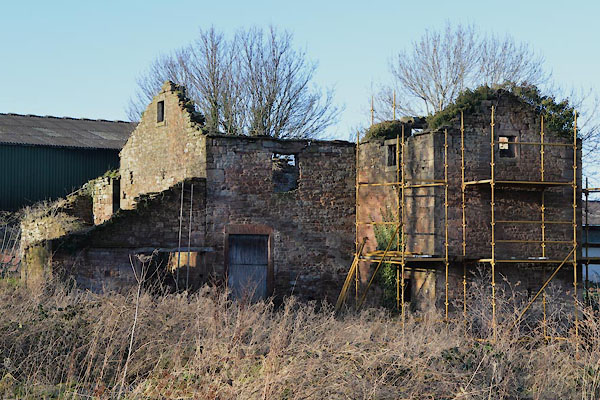 CGY16.jpg (taken 15.12.2017) |
||
|
|
||
| evidence:- | old map:- OS County Series (Cmd 28 4) |
|
| source data:- | Maps, County Series maps of Great Britain, scales 6 and 25
inches to 1 mile, published by the Ordnance Survey, Southampton,
Hampshire, from about 1863 to 1948. "Corn Mill / Mill Race" |
|
|
|
||
| evidence:- | probably old map:- Donald 1774 (Cmd) |
|
| source data:- | Map, hand coloured engraving, 3x2 sheets, The County of Cumberland, scale about 1
inch to 1 mile, by Thomas Donald, engraved and published by Joseph Hodskinson, 29
Arundel Street, Strand, London, 1774.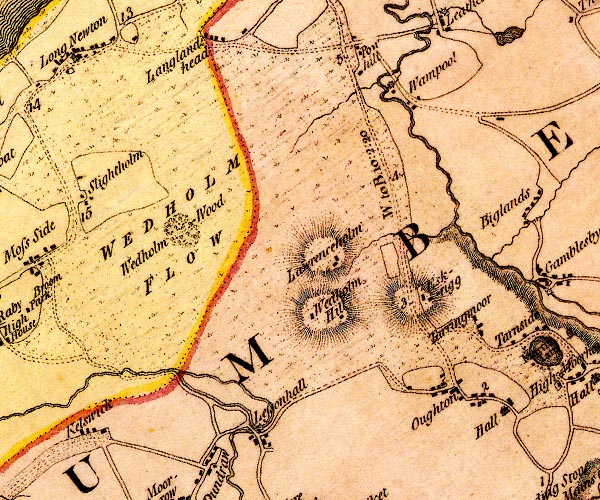 D4NY25SW.jpg circle with rays, mill wheel; a water mill item:- Carlisle Library : Map 2 Image © Carlisle Library |
|
|
|
||
| evidence:- | database:- Listed Buildings 2010 placename:- Old Mill item:- date stone (1834) |
|
| source data:- | courtesy of English Heritage "THE OLD MILL / / / WAVERTON / ALLERDALE / CUMBRIA / II / 72006 / NY2230550268" |
|
|
|
||
 Lakes Guides menu.