 Old Cumbria Gazetteer
 |
 |
|
| roman fort, Watchcross | ||
| locality:- | Watchcross | |
| civil parish:- | Irthington (formerly Cumberland) | |
| county:- | Cumbria | |
| locality type:- | roman fort | |
| coordinates:- | NY47616014 (about) | |
| 1Km square:- | NY4760 | |
| 10Km square:- | NY46 | |
|
|
||
| evidence:- | old map:- OS County Series (Cmd 17 10) |
|
| source data:- | Maps, County Series maps of Great Britain, scales 6 and 25
inches to 1 mile, published by the Ordnance Survey, Southampton,
Hampshire, from about 1863 to 1948. "CAMP (Site of)" |
|
|
|
||
| evidence:- | old map:- Donald 1774 (Cmd) |
|
| source data:- | Map, hand coloured engraving, 3x2 sheets, The County of Cumberland, scale about 1
inch to 1 mile, by Thomas Donald, engraved and published by Joseph Hodskinson, 29
Arundel Street, Strand, London, 1774.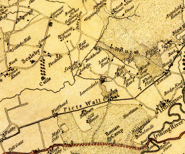 D4NY46SE.jpg "Roman Camp" square within a square; roman fort item:- Carlisle Library : Map 2 Image © Carlisle Library |
|
|
|
||
| evidence:- | possibly old map:- Pennant 1777 placename:- Aballaba |
|
| source data:- | Map, hand coloured engraving, A Map of Scotland, Hebrides and
Part of England, drawn for Thomas Pennant, engraved by J Bayly,
published by Benjamin White, London, 1777. click to enlarge click to enlargePEN1Cm.jpg "Aballaba" square; roman camp on Hadrian's Wall item:- private collection : 66 Image © see bottom of page |
|
|
|
||
| evidence:- | probably old text:- Camden 1789 (Gough Additions) item:- roman inscription; inscription, roman; House Steeds |
|
| source data:- | Book, Britannia, or A Chorographical Description of the Flourishing Kingdoms of England,
Scotland, and Ireland, by William Camden, 1586, translated from the 1607 Latin edition
by Richard Gough, published London, 1789. goto source goto sourcePage 203:- "..." "At Old wall about two miles west from Cambeck fort are two inscriptions of the centurial kind:" "LEG. II. AVG. [V] IVLI. TE RTVLLIA." "and" "[V] COISIL NCINI." "Mr. Horsley supposed them to belong to the station at Watch cross or somewhere by Scaleby castle. In the field called the House steeds near Watch cross, one of the altars now at Scaleby castle was ploughed up, but had no inscription on it. Another of the altars in the same castle, had been neglected till Mr. Gilpin took it into his garden. This had probably belonged to the same station." |
|
|
|
||
| evidence:- | old text:- Camden 1789 (Gough Additions) placename:- Watchcross |
|
| source data:- | Book, Britannia, or A Chorographical Description of the Flourishing Kingdoms of England,
Scotland, and Ireland, by William Camden, 1586, translated from the 1607 Latin edition
by Richard Gough, published London, 1789. goto source Page 227, Mr Horsley:- "..." ""A little detached from the walls to the south is a Roman fort about four chains and a half square, called WATCHCROSS, and, as I was assured by the country people, and have had it since farther confirmed, a military way has gone near it, or between it and the military way belonging to the wall; for they often plow up paving stones here, and think part of the highway to Brampton to be upon it. This is the least station in the line of the wall, and is as much plundered of its stones as that at Brugh or Drumbrugh. However the ramparts and ditches are very fair and visible. It is about half a mile from Bleatern. The military way, which I just now mentioned, has gone from Cambeck or Carrvoran to Stanwicks, like a string to a bow. And so Watchcross stands here in much the same manner as Little Chesters does in Northumberland. Near Bleatern the walls runs through mossy ground, and the foundation here has been made with piles of wood. Hadrian's vallum goes round this bad ground, and runs at ten chains distance from Severus's wall."" |
|
|
|
||
Lakes Guides menu.