 Old Cumbria Gazetteer
 |
 |
|
| Spital, Wigton | ||
| Spital | ||
| civil parish:- | Wigton (formerly Cumberland) | |
| county:- | Cumbria | |
| locality type:- | buildings | |
| coordinates:- | NY26324939 | |
| 1Km square:- | NY2649 | |
| 10Km square:- | NY24 | |
| references:- | Listed Buildings 2010 |
|
|
|
||
| evidence:- | old map:- OS County Series (Cmd 29 6) placename:- Spital |
|
| source data:- | Maps, County Series maps of Great Britain, scales 6 and 25
inches to 1 mile, published by the Ordnance Survey, Southampton,
Hampshire, from about 1863 to 1948. |
|
|
|
||
| evidence:- | old map:- Donald 1774 (Cmd) placename:- Spittle |
|
| source data:- | Map, hand coloured engraving, 3x2 sheets, The County of Cumberland, scale about 1
inch to 1 mile, by Thomas Donald, engraved and published by Joseph Hodskinson, 29
Arundel Street, Strand, London, 1774.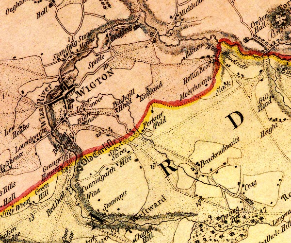 D4NY24NE.jpg "Spittle" block or blocks, labelled in lowercase; a hamlet or just a house item:- Carlisle Library : Map 2 Image © Carlisle Library |
|
|
|
||
| evidence:- | database:- Listed Buildings 2010 placename:- Spittal Farm item:- date stone (1707) |
|
| source data:- | courtesy of English Heritage "SPITTAL FARMHOUSE / / / WIGTON / ALLERDALE / CUMBRIA / II / 72063 / NY2630249404" |
|
|
|
||
| evidence:- | database:- Listed Buildings 2010 |
|
| source data:- | courtesy of English Heritage "BYRE TO NORTH OF SPITTAL FARMHOUSE / / / WIGTON / ALLERDALE / CUMBRIA / II / 72065 / NY2634249407" |
|
|
|
||
| evidence:- | database:- Listed Buildings 2010 |
|
| source data:- | courtesy of English Heritage "BARN ADJOINING TO NORTH WEST OF SPITTAL FARMHOUSE / / / WIGTON / ALLERDALE / CUMBRIA / II / 72064 / NY2630649386" |
|
|
|
||
 Lakes Guides menu.