 Old Cumbria Gazetteer
 |
 |
|
| St Michael, Workington (2) | ||
| gone | ||
| St Michael's Chapel | ||
| site name:- | Chapel Hill | |
| site name:- | St Michaels Mount | |
| civil parish:- | Workington (formerly Cumberland) | |
| county:- | Cumbria | |
| locality type:- | chapel | |
| coordinates:- | NX98532831 (guess) | |
| 1Km square:- | NX9828 | |
| 10Km square:- | NX92 | |
|
|
||
| evidence:- | old map:- OS County Series (Cmd 53 10) |
|
| source data:- | Maps, County Series maps of Great Britain, scales 6 and 25
inches to 1 mile, published by the Ordnance Survey, Southampton,
Hampshire, from about 1863 to 1948. "Chapel Hill / St MichaelsMount" |
|
|
|
||
| evidence:- | probably old map:- Saxton 1579 placename:- St Michael Chapel |
|
| source data:- | Map, hand coloured engraving, Westmorlandiae et Cumberlandiae Comitatus ie Westmorland
and Cumberland, scale about 5 miles to 1 inch, by Christopher Saxton, London, engraved
by Augustinus Ryther, 1576, published 1579-1645.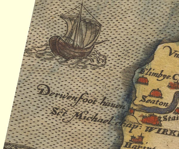 Sax9NX93.jpg Tower, symbol for a house, hall, tower, etc. "Sct Michael chap:" On hill S of rivermouth. item:- private collection : 2 Image © see bottom of page |
|
|
|
||
| evidence:- | old map:- Speed 1611 (Cmd) placename:- St Michael's Chapel |
|
| source data:- | Map, hand coloured engraving, Cumberland and the Ancient Citie
Carlile Described, scale about 4 miles to 1 inch, by John Speed,
1610, published by J Sudbury and George Humble, Popes Head
Alley, London, 1611-12.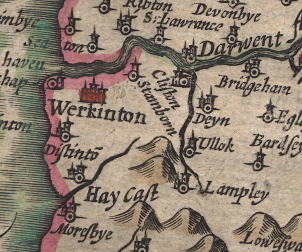 SP11NY02.jpg "St. Michaels chap" circle, tower item:- private collection : 16 Image © see bottom of page |
|
|
|
||
| evidence:- | old map:- Jansson 1646 placename:- St Michaels Chappell |
|
| source data:- | Map, hand coloured engraving, Cumbria and Westmoria, ie
Cumberland and Westmorland, scale about 3.5 miles to 1 inch, by
John Jansson, Amsterdam, Netherlands, 1646. JAN3NY02.jpg "S. Michaels chap" Building and tower with cross. item:- JandMN : 88 Image © see bottom of page |
|
|
|
||
| evidence:- | old map:- Morden 1695 (Cmd) placename:- St Michaels Chapel |
|
| source data:- | Map, uncoloured engraving, Cumberland, scale about 4 miles to 1
inch, by Robert Morden, 1695, published by Abel Swale, the
Unicorn, St Paul's Churchyard, Awnsham, and John Churchill, the
Black Swan, Paternoster Row, London, 1695-1715. MD12NY02.jpg "St. Michaels Chap" Circle. item:- JandMN : 90 Image © see bottom of page |
|
|
|
||
| evidence:- | old text:- Gents Mag placename:- How Michael Chapel item:- sea mark |
|
| source data:- | Magazine, The Gentleman's Magazine or Monthly Intelligencer or
Historical Chronicle, published by Edward Cave under the
pseudonym Sylvanus Urban, and by other publishers, London,
monthly from 1731 to 1922. goto source goto sourceGentleman's Magazine 1748 p.4 "... [crossing the Derwent southward] On the opposite side we came up with the light-house and high land which we had seen for several miles; they are principal sea-marks for Workington harbour, and the Scotch coast, which appears exactly as I have drawn it." 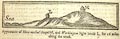 click to enlarge click to enlargeG748E01.jpg "Appearance of How-michael chapel H, and Workington light house L, for 16 miles along the coast." |
|
|
|
||
| evidence:- | old text:- Gents Mag 1748 item:- leading line |
|
| source data:- | goto source Gentleman's Magazine 1748 p.291  click to enlarge click to enlargeG748E04.jpg "... When Howmichael chapel and the saddle on Bees head are in one line, you may avoid the Swap; ..." |
|
|
|
||
| evidence:- | old map:- Donald 1774 (Cmd) |
|
| source data:- | Map, hand coloured engraving, 3x2 sheets, The County of Cumberland, scale about 1
inch to 1 mile, by Thomas Donald, engraved and published by Joseph Hodskinson, 29
Arundel Street, Strand, London, 1774. D4NX92NE.jpg "Chapel" church item:- Carlisle Library : Map 2 Image © Carlisle Library |
|
|
|
||
| evidence:- | old drawing:- Smith 1746 B placename:- How Michal Chapel |
|
| source data:- | Drawing, pencil and ink, A View of the Land at Darwent Mouth, in a Survey of the Coast
of Cumberland, by George Smith, 1746.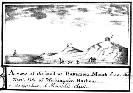 click to enlarge click to enlargeSM2103.jpg ms at bottom:- "A View of the land at Darwent Mouth from the / North Side of Workington Harbour. / a, the Lighthouse, ,b, How-michal Chapel." item:- Carlisle Library : 5.3 Image © Carlisle Library |
|
|
|
||
Lakes Guides menu.