 Old Cumbria Gazetteer
 |
 |
|
| Carlisle: Blackfriars Street | ||
| Blackfriars Street | ||
| locality:- | Carlisle | |
| civil parish:- | Carlisle (formerly Cumberland) | |
| county:- | Cumbria | |
| locality type:- | street | |
| coordinates:- | NY40085577 (etc) | |
| 1Km square:- | NY4055 | |
| 10Km square:- | NY45 | |
|
|
||
| evidence:- | old map:- OS County Series (Cmd 23 3) placename:- Blackfriars Street |
|
| source data:- | Maps, County Series maps of Great Britain, scales 6 and 25
inches to 1 mile, published by the Ordnance Survey, Southampton,
Hampshire, from about 1863 to 1948. "Blackfriars Street" |
|
|
|
||
| evidence:- | old painting:- |
|
| source data:- | Painting, watercolour, Blackfriars Street, Carlisle, Cumberland, by A Bendle, 1890s.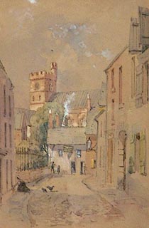 click to enlarge click to enlargePR1160.jpg Fine day; view along Blackfriars Street looking towards the cathedral; the foreground is thrown into shadow. To left of foreground a woman kneels to clean her front doorstep, a cat and a hen? standing in the road nearby. labelled at reverse:- "Joe Bendle, 48 Berners S., Leicester; By Father A.B." item:- Tullie House Museum : 1975.73 Image © Tullie House Museum |
|
|
|
||
| evidence:- | old map:- Donald 1774 (Cmd) |
|
| source data:- | Map, hand coloured engraving, 3x2 sheets, The County of Cumberland, scale about 1
inch to 1 mile, by Thomas Donald, engraved and published by Joseph Hodskinson, 29
Arundel Street, Strand, London, 1774.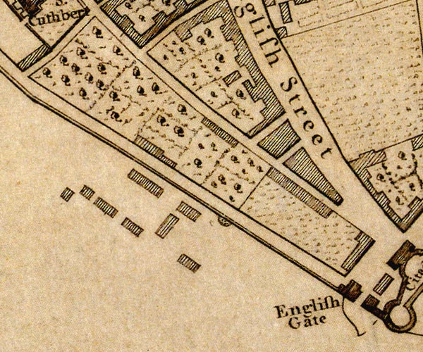 D44055D.jpg street item:- Carlisle Library : Map 2 Image © Carlisle Library |
|
|
|
||
 Lakes Guides menu.