 Morden 1695 (Wmd) NY50


|

|
|
|
gazetteer links places may or may not be labelled on the map |
||

|
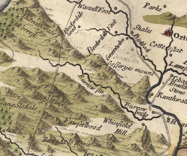
-- Birk Beck -- "Birkbeck" |
|
|
|
-- Borrow Beck -- "Burrow flu" |
|
|
|
-- Bretherdale Beck |
|
|
|
-- Bretherdale Foot -- "Brederdale Foot" |
|
|
|
-- Bretherdale Head -- "Brederdale head" |
|
|
|
-- Forest Hall -- "Fawsetwood" |
|
|
|
-- High Greenholme -- "Groenholm" |
|
|
|
-- Horse House (?) -- "Horse Hause" |
|
|
|
-- Jeffrey's Mount -- "Gefferyes mount" |
|
|
|
-- Low Borrowbridge -- "Burrow bridg" |
|
|
|
-- Lune's Bridge |
|
|
|
-- Kendal to Shap |
|
|
|
-- Shap to Tebay |
|
|
|
-- Roundthwaite -- "Runthwate" |
|
|
|
-- Whinfell Beacon -- "Whinfield Hill" |
|
|
civil parishes The area roughly includes parts of parishes:- Shap Rural Whinfell Orton S Tebay Fawcett Forest Longsleddale Grayrigg Strickland Roger Whitwell and Selside Crosby Ravensworth |
||
|
|
||
|
|
Lakes Guides menu. | |