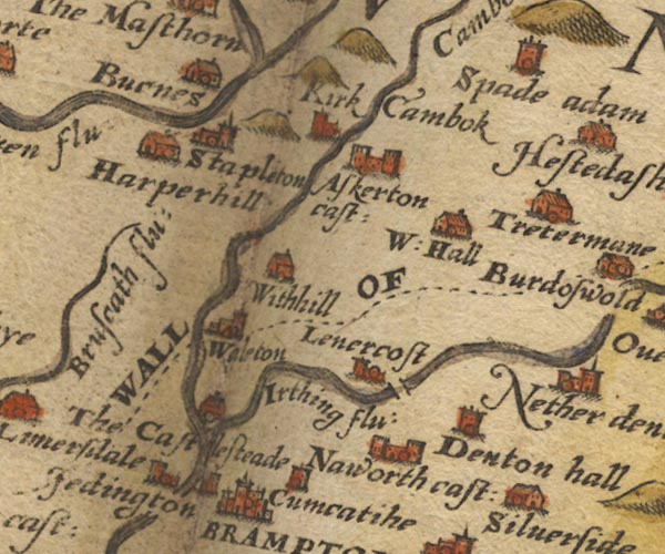
 Saxton 1576 NY56


|

|
|
|
gazetteer links places may or may not be labelled on the map |
||

|
-- Askerton Castle -- "Askerton cast:" |
|
|
|
-- Cam Beck -- "Cambok flu:" |
|
|
|
-- Castlesteads -- "The Castelsteade" |
|
|
|
-- Denton Hall -- "Denton hall" |
|
|
|
-- Hadrian's Wall -- "THE WALL OF THE PICTES" |
|
|
|
-- Harperhill -- "Harperhill" |
|
|
|
-- Irthing, River -- "Irthing flu:" -- "Irthing
flu:" -- "Trout bek" |
|
|
|
-- Irthington -- "Jedington" |
|
|
|
-- Kirkcambeck -- "Kirk Cambok" |
|
|
|
-- Lanercost Bridge |
|
|
|
-- Lanercost -- "Lenercost" |
|
|
|
-- Low Luckens -- "Bucnes" |
|
|
|
-- Naworth Castle (?) -- "Naworth cast:" |
|
|
|
-- Spadeadam -- "Spade adam" |
|
|
|
-- Stapleton -- "Stapleton" |
|
|
|
-- Triermain -- "Tretermane" |
|
|
|
-- Walton -- "Waleton" |
|
|
|
-- West Hall -- "W: hall" |
|
|
|
-- White Hill -- "Withhill" |
|
|
civil parishes The area roughly includes parts of parishes:- Stapleton Askerton Hethersgill Walton Irthington Waterhead Kingwater Brampton Burtholme Nether Denton Farlam |
||
|
|
||
|
|
Lakes Guides menu. | |